Free · France
How Rail and Geography Shape Regional Town Life
A station symbol on a map tells you that a place connects to a railway. It does not tell you whether that connection fits a working day, a shopping trip, a medical appointment or a visit to someone in the next village. For those questions, the shape of the land and the shape of the service matter together.
Two routes in Occitanie make the distinction concrete: the Train Jaune through the eastern Pyrenees, and the Nîmes–Le Grau-du-Roi line towards the Mediterranean coast. They are not examples of a simple contrast between an “isolated mountain” and an “easy seaside.” Each combines opportunities with constraints. A mountain railway can connect places across difficult terrain; a coastal terminus can be useful without providing a direct train in every direction.
The point is not to choose a winning town. It is to understand how a transport link becomes—or fails to become—usable access in daily life.
Dated operating note: As checked on 28 October 2026, during the works window, SNCF Réseau's notice states that rail services on the entire Train Jaune line are interrupted 28 September–30 October 2026 inclusive for works. It describes regular liO coaches and additional Sunday coach services, not a train operating normally. Do not use this article as confirmation of a departure or of reopening after that window; check current operator information for your date. SNCF Réseau notice, 25 September 2026.
Mountain geography is part of the transport system
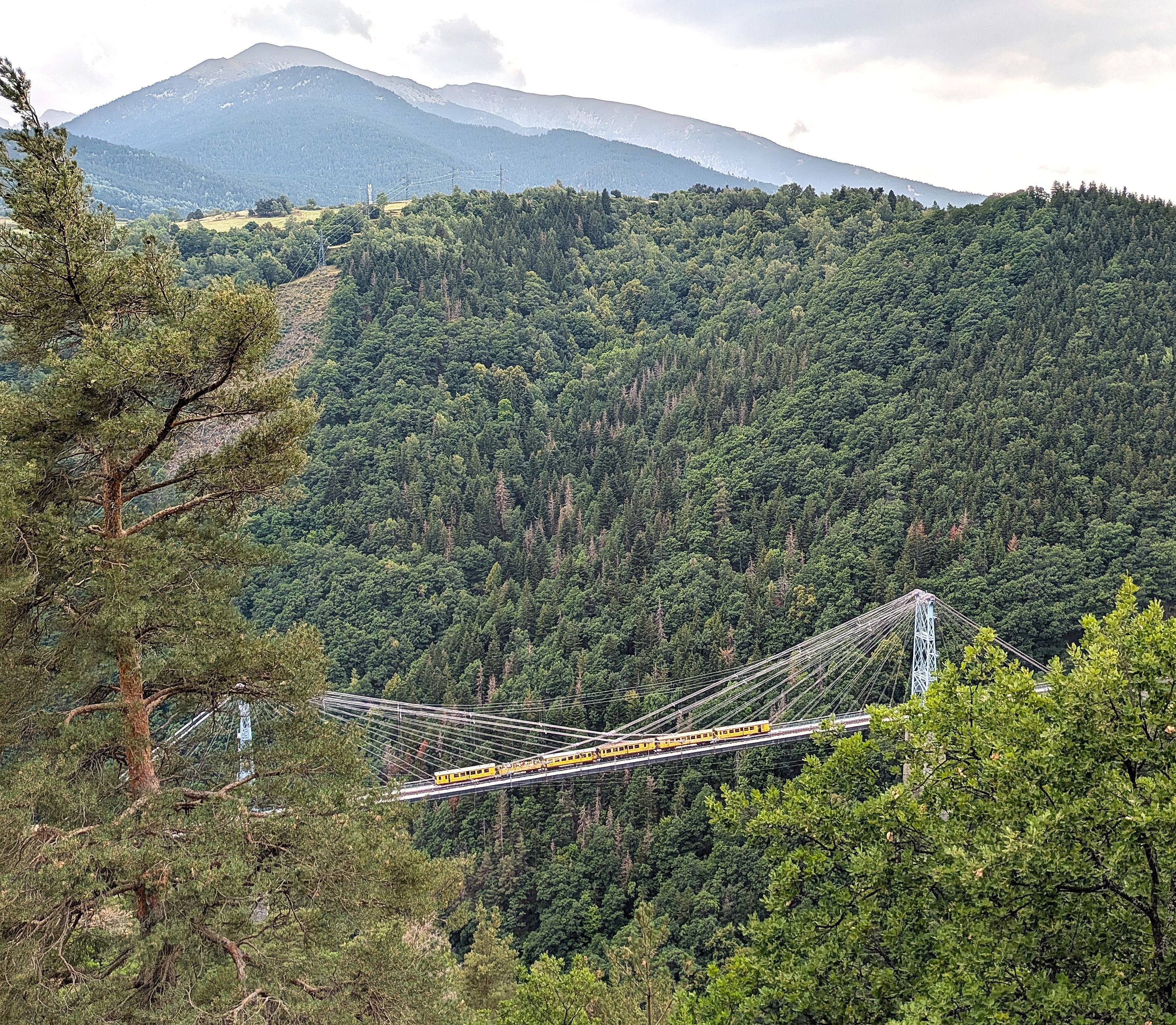
Train Jaune crossing Pont Gisclard, with a view towards the high ground of Planès, 25 August 2025. This photograph of a train in operation shows the railway's relationship to steep terrain; it does not show service during the October 2026 works. Photo: Alan Mattingly, original file, CC0 1.0. Uncropped, proportionally resized.

The Communauté de communes Pyrénées Catalanes describes the Train Jaune's roughly 63-kilometre route between Villefranche-de-Conflent and Latour-de-Carol through the Têt valley and the Cerdagne plateau. Those place names describe more than scenery. A valley, a slope and a plateau create different problems for a line that must connect settlements rather than simply take the shortest straight path. The intermunicipal transport page situates the railway within local mobility, not only sightseeing.
The destination's history page explains that metre-gauge track was selected in part to reduce costs and permit tighter curves. It also relates the line's construction to the effort to improve access to the high cantons. The first section to Mont-Louis–La Cabanasse opened in 1910. These choices make the railway a response to geography and policy, not an inevitable feature of the landscape. The Train Jaune history supplies that engineering context.
The bridge photograph makes a useful visual comparison with an ordinary line on a map. The map can show a connection across the valley; the image shows that maintaining the connection requires a substantial structure. It does not tell us how often trains run, whether a given passenger can board, or how long a journey will take on a particular day. Those are separate questions requiring operational information.
“Served by a station” is not the end of a journey
Mont-Louis provides a practical example. The Train Jaune visitor-information page describes an uphill connection from the station to the fortified town, approximately one kilometre, and says there is no arrival shuttle (local practical information). That is a meaningful difference from stepping directly into a town-centre street. Its suggested walking time is not a promise suitable for everyone: mobility, luggage, weather and the precise destination all change the task. That local guidance should be supplemented by a current access check if that link matters to your journey.
For someone comparing places to live, an attractive station-to-station journey can hide an inconvenient door-to-door one. Consider the full chain: home to station, waiting, travel, any transfer, and the final route to the service you need. A short final distance can still be the difficult segment if it involves a climb, steps, an unsuitable pavement or an unavailable onward connection.
This is not an argument against using the train. It is an argument for describing access accurately. A railway can be valuable to a community without making every household car-independent or every visitor's trip straightforward. Conversely, someone whose home and destination fit the service may find it extremely useful. The relevant unit is a real journey, not an abstract town score.
Maintenance changes what a connection means
The autumn 2026 works notice is also evidence of the landscape's continuing demands. SNCF Réseau lists earthwork reinforcement, rock-face clearance and signalling-component replacement. Those are operating needs, not picturesque details. The notice temporarily replaces the assumption “there is a railway” with a different question: which actual service is available during this period?
Do not assume that a coach substitute uses the same stop, accepts the same equipment, has the same capacity or takes the same time as the train. Check each relevant detail in the dated service information. A general statement that a line operates year-round does not cancel a specific closure notice.
For recurring journeys, ask what the backup would cost in money and time, and whether it exists at the hours you need. Avoid turning that question into an unsupported prediction that mountain transport is always unreliable. This article has not measured punctuality or surveyed residents; it identifies the checks that a mapped connection leaves unanswered.
A coastal station can connect one direction better than another
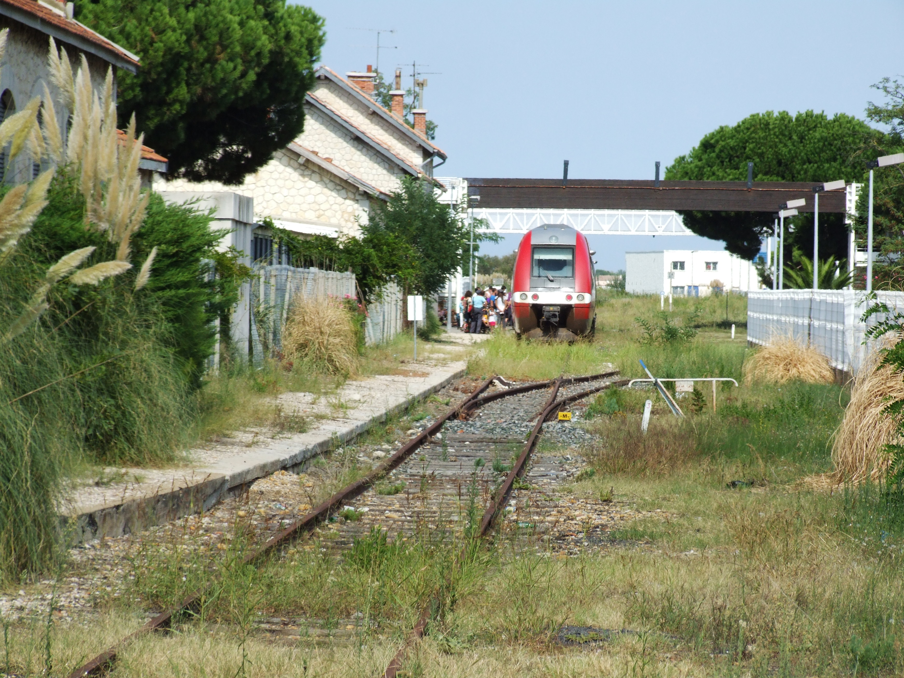
Le Grau-du-Roi station, 18 August 2011. The dated image illustrates a town's railway arrival point, not current rolling stock, track condition, accessibility or frequency. Photo: Clem Rutter, Rochester, Kent, original file, CC BY 3.0, selected from the photographer's offered licences. Uncropped, proportionally resized.

Le Grau-du-Roi has a rail link with Nîmes. The official SNCF route page identifies central-city arrival points, but its frequency summaries are internally inconsistent: one part gives an average of five return journeys, another refers to around ten. Neither figure is treated here as a dependable timetable. Use the dated journey search and traffic information instead. The SNCF route page establishes the route; it does not justify inventing a single reconciled frequency.
The local tourism office makes a different distinction that a regional map may obscure: there is no direct rail connection from Montpellier to Le Grau-du-Roi. Its access page describes public-transport alternatives and distinguishes arrival from Nîmes centre from the separate Nîmes Pont du Gard station. “Arrive in Nîmes” is therefore not enough information to plan an onward journey. The office's access guidance is a starting point; its bus and tram details still require checking with the current operator.
A station in the centre is useful, but the town does not end at the platform. The same local source distinguishes the centre from more distant neighbourhoods and points to an urban shuttle. For a particular address, check the onward route rather than assuming that “coastal” means flat, short, accessible or comfortably walkable for every person and condition. No address-level walking or accessibility audit is claimed here.
Seasonality is a service question, not a stereotype
A visitor may evaluate a connection by whether it makes a pleasant day out. A resident may need an early arrival, a late return or a trip repeated several times a week. The same line can succeed for one use and fail for the other without either person's experience being wrong.
That is why a summer photograph or a promotional ticket headline cannot answer a year-round question. Test an ordinary weekday, a weekend and the season relevant to you. If a reservation or capacity rule applies, treat it as part of the service, not a detail to work around. The Grau-du-Roi tourism page explicitly directs travellers to reserve; confirm the current rule and a valid ticket for the actual train with the operator. Do not assume that another departure's ticket guarantees boarding.
The comparison should remain proportionate. This article does not establish that coastal services are necessarily more frequent, that mountain residents depend on one mode, or that either place has a particular commuting pattern. Such claims would require separate data. What the examples establish is that route direction, last-mile access, dated operation and the purpose of a journey must be considered together.
A five-step check for any regional town
Use these questions for one concrete trip rather than for a whole region in the abstract.
1. Name both doors. Write the actual starting address and destination, not just two municipality names. Identify the exact station at each end. Similar station names can conceal a transfer.
2. Fix the day and the deadline. Choose a real date and required arrival time, then check the return separately. Do not infer a return from the existence of an outward train. Repeat for another day if the journey must be regular.
3. Add every non-train segment. Include walking, climbing, local buses, transfers and waiting. If assistance, step-free access or carriage of a bicycle is essential, obtain current, specific information; a scenic photograph cannot verify any of them.
4. Read notices before the general description. Record the validity dates of works, altered timetables and replacement services. If two summaries disagree, leave the disputed detail unresolved until a dated operator result establishes it. A neat number is not worth a missed journey.
5. Test the consequence of failure. Ask what happens if the final service is missed or a connection is unavailable. A feasible alternative must exist at the required time and be affordable to the person using it. “Take a taxi” is not a verified plan without availability and cost information.
A useful conclusion might read: “This address works for my checked weekday appointment by the route shown, but I have not established a Sunday return.” That is less sweeping than “the town is well connected,” and much more useful.
What the two routes teach
Railways can make difficult terrain crossable and put a town within reach of another centre. They can also create strong connections along one corridor while leaving nearby places awkward to reach. Geography helps explain the network, but timetables, investment, maintenance and onward services determine how people can use it.
Look beyond the station symbol. Ask what the connection lets a person do, on a particular day, from a particular address—and which part of that answer is still unverified. That is how rail geography becomes an understanding of regional town life rather than a collection of scenic routes.
Sources and checking notes
Remote desk research checked 28 October 2026. No live ticket purchase, booked itinerary, field survey, punctuality measurement or resident interviews. All departure times, fares, assistance and current access require separate date-specific verification.
- Communauté de communes Pyrénées Catalanes — En train: route and physical setting. Undated promotional fares not reproduced.
- Destination Train Jaune — Histoire et prouesses: gauge choice, access purpose and first opening. Technical superlatives and historical accident details not reused.
- Destination Train Jaune — Horaires et informations: Mont-Louis uphill last mile and need to check operational information. Conflicting fare amounts and broad all-weather language not treated as current guarantees.
- SNCF Réseau — Autumn 2026 works notice, 25 September 2026: whole-line closure 28 September–30 October inclusive, work types and coach context. Reopening not independently confirmed.
- SNCF liO — Nîmes–Le Grau-du-Roi: route, central station setting and current search entry point. Inconsistent frequency summaries explicitly not reconciled by invention.
- Le Grau-du-Roi tourism office — Access and local travel: distinct Nîmes stations, no direct Montpellier rail link, local onward transport and reservation guidance. Individual bus/tram line numbers, fares and walking times omitted pending date-specific checks.