Free · France
Nancy: Place Stanislas and civic planning
The northern side of Place Stanislas does not match the height of its neighbours. Opposite Nancy's Hôtel de Ville, the buildings known as the basses-faces form a low frontage interrupted by the route towards the Arc Héré. The city's heritage leaflet identifies their reduced height as a military requirement: construction could not obstruct the fortifications. What looks like a graceful opening in a monumental composition therefore preserves a restriction imposed on its designer. Ville de Nancy, heritage leaflet, page 2.
The ensemble was commissioned under Stanislas Leszczynski, Duke of Lorraine and Louis XV's father-in-law, with Emmanuel Héré as architect. UNESCO's assessment connects its princely display with access to public institutions. The basses-faces expose how that grand ambition had to accommodate a particular site. UNESCO, statement of significance.
These buildings make a useful test of the familiar claim that the square united Nancy. Joining two districts was not simply a matter of removing whatever stood between them. It required decisions about what could remain, what could be concealed and how people would pass through. The low northern frontage gives those decisions an architectural form. Its subsequent history also shows why a coherent appearance should not be mistaken for an unchanging public space.

The northern side of Place Stanislas in a 2014 panorama. The basses-faces sit below the neighbouring monumental frontages, while the opening leads towards the Arc Héré. The stitched view illustrates spatial relationships, not measured building heights or an eighteenth-century scene. Photo: Philippe Alès, Wikimedia Commons; CC BY-SA 3.0. Unmodified by publisher.

A connection negotiated with the army
Nancy's municipal history describes the medieval Ville Vieille and the Renaissance Ville Neuve as separated by bastions, ditches and an esplanade. In 1751, Stanislas proposed placing his royal square in this intervening space. Marshal de Belle-Isle opposed a scheme involving the destruction of the Haussonville and Vaudémont bastions and their connecting wall. An alternative at the market encountered resistance from merchants. The account dates approval of the adapted project to January 1752 and the square's inauguration to November 1755. Ville de Nancy, history of the square.
The dispute makes the site's constraints visible. An open space could serve a defensive purpose without being vacant or available for unrestricted rebuilding.
The same municipal account explains that the basses-faces were kept low so that cannon could fire from the old town's ramparts if necessary. Municipal explanation of the basses-faces. That does not make the buildings military architecture in disguise. Rather, it makes their silhouette evidence of military influence over civic construction. The restriction concerned what must remain possible above them, not just the activity within them.
Héré nevertheless used the site to establish a continuous urban composition. The city leaflet explains that the existing Place de la Carrière supplied the axis for the triumphal arch, Rue Héré and the new square. Ville de Nancy, explanation of the axis, page 2. A low edge could frame that route without becoming another towering barrier. The result joined enclosure and passage: the square acquired a recognisable boundary, while the opening directed attention beyond it.
Plans that were also arguments
The municipal archives preserve Héré's 1753 publication under reference 15 Fi 3. Its catalogue separates a general plan, views towards the arch and town hall, and an elevation of the triumphal arch described as a royal gate between the two towns. The different sheets made the project intelligible at different scales, from the district to an individual structure. Archives municipales de Nancy, architectural plan collections.
Yet these are not interchangeable with photographs of completed work. Astrid Mallick, responsible for graphic collections at the Bibliothèque Stanislas, explains on the BnF's heritage site that the volume appeared two years before the inauguration. She identifies a revealing device in its perspective views: one leaves the town hall under construction, another leaves the basses-faces unbuilt, although the buildings were constructed concurrently. Each view could thus give prominence to a different part of the design. Astrid Mallick, account of the Héré albums.
That warning changes how an apparent gap should be understood. An absent building in a project image need not establish an actual construction sequence. The publication was helping viewers imagine an ordered city; its choices of visibility belonged to that purpose. Reading it as a neutral progress report would erase the architect's role in presenting his own achievement.
A later print provides a different kind of visual evidence. The Bibliothèques de Nancy reproduction titled Place Stanislas. Les trottoirs shows the low frontage, the opening towards the arch and the statue isolated in a broad foreground. Small figures punctuate the space rather than filling it. The departmental archives catalogue a print of this title by J. Cayon, published in 1853. Bibliothèques de Nancy, reproduced print; Archives départementales de Meurthe-et-Moselle, 1 Fi 1678, page 211.

The image makes the relationship between low buildings and open route readily legible. It cannot tell us how crowded the place usually was, or how every passer-by experienced it. Its spaciousness is a representational choice as well as a record of architectural relationships.
What the museum brings back into view
At the Musée des Beaux-Arts, the military ground behind the elegant square becomes material evidence again. The museum describes its basement as containing remains of Nancy's fifteenth-to-seventeenth-century fortifications, incorporated into the presentation of the Daum glass collection. Musée des Beaux-Arts de Nancy, building history.
This differs from the civic history's account of a successful connection. A visitor-facing narrative can explain how an obstacle was overcome; surviving masonry prevents that obstacle from becoming merely a line in the story. The museum's setting also reverses the original hierarchy of attention. Defensive remains are now something to look at, while objects made for quite different purposes occupy their surroundings. This is a present museum arrangement, not a reconstruction of eighteenth-century defence.
Archaeology further complicates the idea of a vacant strip awaiting improvement. Amaury Masquilier's report on the 2004–2005 works records earlier housing near the present museum, including modest dwellings with cellars and wells. For the royal square itself, he identifies foundation remains, water supply and sewer infrastructure, and limited surviving paving. The ground had been raised and levelled before its new surface was laid. Masquilier, Lorraine regional archaeological report, printed pages 29–30.
The northern edge was therefore part of an engineered environment, not a façade composition hovering above untouched land. Making a connection meant managing ground and water as well as views. These findings do not measure how well the square served all its users, but they expose work that an architectural prospect tends to suppress.
The Musée lorrain's 2005 exhibition on Place Stanislas explicitly brought together archaeology, urban history and the expression of power. Organised with Inrap during the renovation, it treated the square as a site with a past beneath and before its monumental form. Musée lorrain, record of the 2005 exhibition. That approach makes the basses-faces more than an attractive exception to symmetry: they belong to a longer history of arranging an urban threshold.
A preserved frontage is not a frozen place
Even the roofline has a history of proposed change. Nancy's archive catalogue lists a drawing by Thiebert dated 10 September 1845, reference 1 Fi 582, comparing the existing roof of the basses-faces with a proposed design. The catalogue establishes that such a proposal survives; it does not establish that the alteration was executed. Archives municipales de Nancy, consulted catalogue listing, entry 1 Fi 582.
This distinction matters because the frontage can look inevitable in retrospect. Its survival conceals the choices through which an inherited shape is accepted, challenged or maintained. A proposal is evidence that someone considered another solution, even where its eventual fate remains unverified.
The major modern change concerned use of the ground. Limédia's local-library exhibition describes the square's conversion into a car park in the 1950s and its pedestrianisation in 2005. It characterises the restoration as a return to a nineteenth-century state. The project architect's own account instead describes recovering an eighteenth-century appearance while retaining contributions from later centuries and accommodating contemporary use. Limédia, history of the square; Agence Pierre-Yves Caillault, restoration account.
These descriptions should not be compressed into a claim that the square simply became “original” again. They emphasise different reference points within a selective restoration. Removing cars changed the relationship between the northern frontage and the open ground without requiring a new monumental composition. The inherited architecture could serve a different allocation of space.
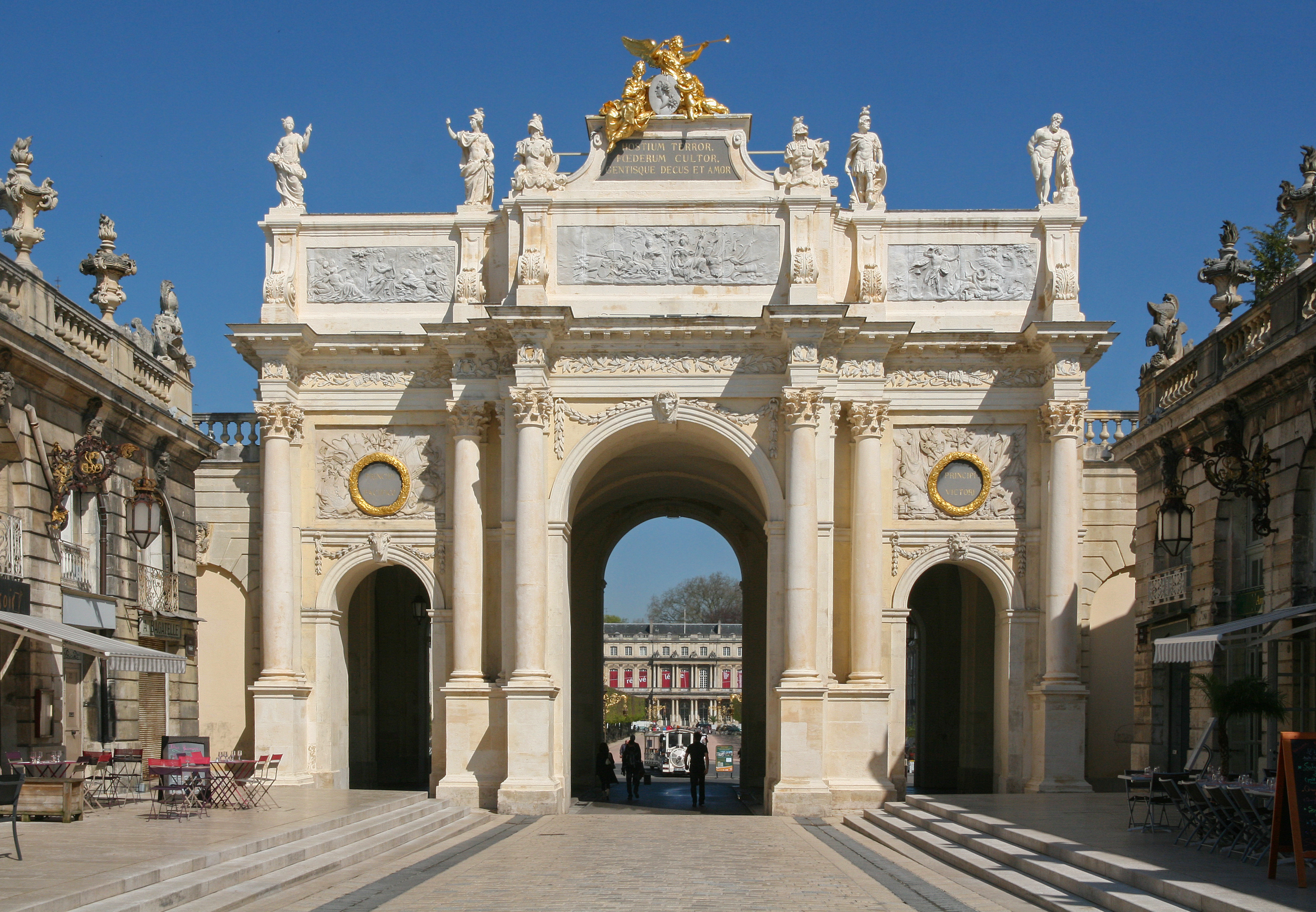
Approaching the Arc Héré on 25 April 2013. The photograph makes the passage between frontage buildings visible. Its terrace furniture and circulation conditions predate the 2024 order discussed below and are not evidence of compliance with that order. Photo: Clément Bardot; perspective correction by Tuxyso, Wikimedia Commons; CC BY-SA 3.0. Unmodified by publisher.

Keeping a way through
The contemporary counterpart to the old question of clearance appears in an unexpectedly ordinary document: terrace regulations. Nancy's order of 10 December 2024, linked from its commerce service when checked on 27 October 2026, includes a special annex for Place Stanislas and Rue Héré. It distinguishes frontage terraces from seasonal occupation of the square's central paved area. On Rue Héré it specifies a pedestrian passage beside the terrace furniture; for the square, it requires respect for identified views, including the town-hall-to-arch axis. Ville de Nancy, terrace order, annex 2, PDF pages 16–17.
The document is evidence of intended management, not proof that every arrangement on the ground complies. Nonetheless, it shows that preserving a view and keeping a route usable remain administrative tasks. A restaurant terrace and a pedestrian crossing do not become compatible merely because both belong to a beautiful square.
The parallel with the eighteenth century is limited but instructive. Today's clearance is not for artillery, and a municipal terrace rule is not a military veto. What persists is the need to decide how occupation and openness coexist. The basses-faces preserve the form of one historical compromise. The space before them continues to require others. Nancy's civic planning is visible here not only in the authority of a completed design, but in the continuing work of making its edges usable.
Locate the town
For regional orientation, open a Google Maps search for Nancy. This community-level search is not an exact building entrance, a verified walking route or permission to enter a workshop, museum or private property. Check the institution’s own current access information separately.
Editorial source and verification notes
The workflow and pre-image statements below preserve the original authoring stage. Subsequent photo amendments and actual independent reviews are recorded in the current QA manifest; these historical statements are not the current review, image-count or storage status.
These notes are internal production material, not part of the article body. Sources were checked on 2026-10-27.
- Approved scope: The supplied read-only workbook was opened with
openpyxlin read-only mode. Sheet01 France, row 111 confirms all map metadata above. The article investigates one feature: the low northern basses-faces and their role in maintaining an urban threshold. No workbook cell or other content ID was changed. F0088 was read only to preserve production conventions, not its prose, structure or argument. - Civic evidence: Municipal history, heritage leaflet and UNESCO statement opened. No original military correspondence was inspected. Cannon trajectories, operational effectiveness, exact heights and costs are not asserted.
- Archival distinction: The Héré album finding aid opened; original plates did not. Their staging is assessed through Mallick's opened BnF essay. The roof proposal was verified only in the archive's opened catalogue listing. The body cites that consulted listing; the parent inventory returned 503 and was not used as inspected evidence. Image, approval history and execution remain unverified; no completed alteration is inferred.
- Direct historical visual evidence: Library reproduction viewed at 600 × 408; no tiny signs or crowd counts inferred. Departmental catalogue, p. 211, confirms title, Cayon, 1853 and 1 Fi 1678, not identity of the physical copy. Print not reproduced.
- Archaeological evidence: The oversized Ministry PDF downloaded from its public URL. Masquilier's report was fully read; printed pages 29–30, PDF pages 30–31, were rendered and inspected. Pre-royal and royal paving were kept distinct. Rue Héré
trottoirsfoundations were not equated with every basses-faces foundation. No author fieldwork is implied. - Museum evidence: The Musée des Beaux-Arts building account and Musée lorrain exhibition record were opened. They establish published interpretation and a historical exhibition, not a room-by-room inspection or a claim that the 2005 exhibition remains on display. The museum basement account concerns fortifications broadly; precise dates and locations of individual masonry phases are not supplied by it.
- Restoration comparison: Limédia and the project architect use different chronological descriptions of the restored appearance. Both are attributed rather than reconciled into a single authentic date. No claim is made that every basses-faces façade was restored in 2005. An April 2013 municipal-magazine item found through search could not be opened reliably and is not used. The architect's project dates are not treated as proof of completion for each individual frontage.
- Current civic management: The opened commerce service page links order ARR_61772. PDF pages 1, 16 and 17 were visually inspected. The article examines planning priorities, not compliance or enforcement; it supplies no personalised legal advice or operational instructions.
- Access limits and unused research: Direct command-line retrieval of Limédia article pages returned a JavaScript anti-bot notice; no challenge was bypassed. Accessible web-tool text and an explicitly linked public image were used. Gallica and several archive viewers failed; the teaching PDF returned 404; Kassel timed out. Unavailable contents support no claims. The 2026 garden programme, a 1993 archaeological article and a library essay on accounts were opened but not used. BnF/Louvre catalogue search leads were not used.
- Source discipline and review state: No source prose is quoted. Source-dependent description and analysis are kept below 200 words per source cumulatively, including these notes; repeated URLs share one budget, and the city leaflet/history are treated conservatively where they overlap. Broader comparisons are this article's analysis. The complete draft was reread and self-edited for chronology, location, citation scope, unsupported observation and repetition. No independent review was submitted or completed. Qwen and DeepSeek remain PENDING_NOT_SUBMITTED; final QA remains NOT_COMPLETE and publication NOT_LIVE. Explicit SOURCE.md format is retained. No DOCX, PDF deliverable, Page, upload, contact, schedule, map edit or publication was created.