Free · France
Concarneau: Ville Close and fishing-port infrastructure
The Quai Suisse, beside Concarneau’s Ville Close, makes an instructive distinction between a maritime town and a usable landing place. Fishing boats needed access that the existing ferry landing could not provide. This article examines that small infrastructure problem and its wider setting, rather than the fish trade’s earnings or the attractions of the old town. Région Bretagne, Quai Suisse, IA29133735.
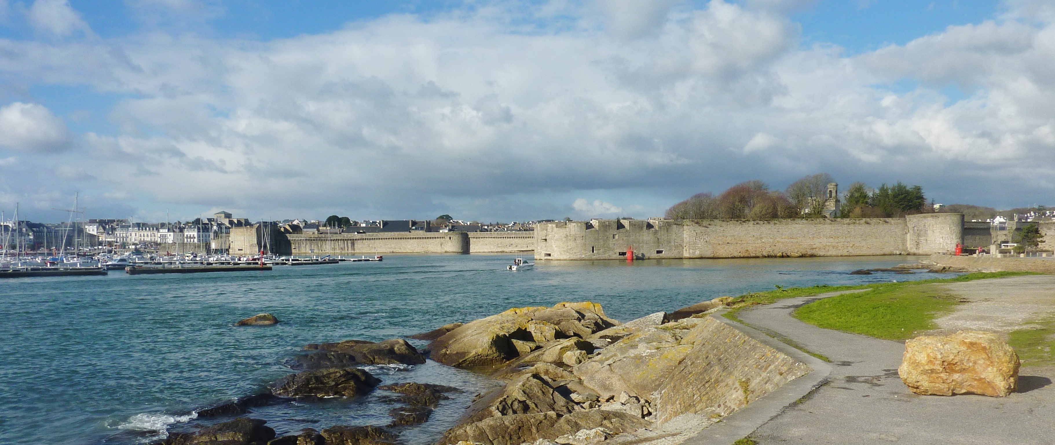
The Ville Close seen from Passage-Lanriec in January 2014. The water, walls and shore provide the setting for the landing-access problem; this overview does not identify each phase of quay construction or a safe present-day landing route. Photo: Moreau.henri, Wikimedia Commons; CC BY-SA 4.0. Unmodified by publisher.

A fortified edge was not automatically a usable quay
The Ville Close occupies a rocky island close to the shore, at the entrance to the Moros estuary. Archaeologist Fanny Tournier’s 1998 account describes the stone enclosure surrounded by seawater at high tide. Her report concerns an archaeological evaluation inside the town, not a survey of fishing facilities. Nevertheless, its description establishes the physical distinction that matters here: a wall beside water is not necessarily a place where a vessel can land people or goods. Fanny Tournier, Concarneau La Ville close, Archéologie médiévale 28, 1998, p. 265.
Tournier also describes repeated changes to the enclosure between the fifteenth and sixteenth centuries, including an artillery tower protecting the harbour entrance. Even the defensive boundary had a construction history rather than a single founding date. The distinction between fortification and port infrastructure therefore concerns purpose as well as age: protecting an entrance to the harbour was a different operation from providing a convenient place to unload. Tournier, 1998, p. 265.
The municipality’s heritage booklet explains how the eastern Passage entrance was altered for the ferry. The old gate was demolished in the late eighteenth century and a gently sloping landing was created, extending into the town to shelter it from the tidal current. The booklet dates a ferry access ramp to 1785. Access required changes to the fortified boundary, not simply permission to pass through it. The opening, the slope and the water beside it formed an arrangement for a specific service. Ville de Concarneau, Focus La Ville Close une île fortifiée, printed pp. 6–7.
The same civic account describes a more drastic possibility for changing the waterfront. When obsolete fortifications were being sold to the municipality in the late nineteenth century, the town wanted their stone for quay construction. Artists arguing for the walls’ historical and aesthetic value helped prevent demolition; the booklet connects their intervention with protection in 1899. Here the relationship between rampart and quay was not harmonious by definition. Materials valuable for harbour improvement were also fabric worth retaining. Ville de Concarneau, Focus, printed pp. 2–3.
A separate place for fishing boats
The regional inventory dates the Quai Suisse to 1907–08, between the Passage landing and the Tour aux Chiens. Citing Concarneau municipal archive file 3 O 1, it explains the fishermen’s difficulty: the ferry’s landing had to remain clear, leaving hazardous rocks as an alternative. The new quay addressed this shortage of usable frontage. Its construction therefore belongs to the twentieth century, even though it lies against old ramparts. The inventory describes masonry, a mooring ring and a ladder, and records subsequent use as a promenade and ferry waiting area. Région Bretagne, Quai Suisse, IA29133735, pp. 1–2.
The surrounding harbour was also being made
The larger chronology reinforces that distinction. The regional quay survey describes an 1819 hydrographic plan with port facilities south of the Ville Close and mud exposed at low tide in the rear harbour. It places construction of the connecting Quai Pénéroff within this early nineteenth-century setting. Later, dredging, filling and quay construction reshaped the rear harbour. The survey dates major Quai Carnot works to 1934–36 and the installation there of the fish auction building to 1938. These were successive interventions, not components of a single medieval harbour plan. Région Bretagne, Les quais du port de Concarneau, IA29133711.
The same survey stresses that quays also supported roads and urban access. A harbour wall could serve circulation on land as well as activity afloat. This helps explain why the history of a short landing structure cannot be reduced to the dates of the neighbouring fortifications. Its usefulness depended on what could approach it from either side. The water’s edge was being reorganised as a working connection between boats and the town.
The regional port authority’s historical summary adds a different emphasis: growing fishing fleets made the outer harbour insufficient, prompting new infrastructure on the mudflats. It also associates the period with the gradual shift from sail to engines. This is a broad operational explanation, not evidence that one particular vessel prompted the Quai Suisse project. Ports de la Région Bretagne, Port de Concarneau.
An archive records the changing waterfront
An official transfer inventory for photographs held by the Finistère departmental archives identifies Concarneau material from around 1900, 1934 and 1937. Its descriptions cover the outer harbour, channel, Ville Close and rear harbour, then name the Aiguillon, Carnot and Lin quays. The 1937 entries include the old fish auction. These headings establish a potentially useful sequence of waterfront records, rather than a single timeless view of the fortified town. Direction départementale des territoires et de la mer du Finistère, photographic transfer inventory, p. 2.
Only the inventory, not those photographs, was inspected for this article. It cannot establish from its titles whether a particular quay was crowded, finished or in disrepair. Its contribution is to identify what can be compared and when. The distinction is productive: an archival catalogue points towards evidence, while the regional inventory already supplies a researched construction history. They should not be presented as two independent eyewitness accounts of the same works.
The museum moves the question aboard
The Musée de la Pêche offers a complementary perspective. Its institutional history dates its opening to 1961 and explains a remit extending beyond Concarneau to fishing techniques and the lives of mariners. Models, equipment and boats form that account. The museum occupies former buildings at the entrance to the Ville Close; its historical presentation connects the Hémérica with questions about the vessel’s operation, onboard life and fish preservation. Musée de la Pêche, L’histoire du Musée.
That approach changes the scale of interpretation. An inventory describes the fixed structure against which a boat can lie. A museum can explain the working spaces carried by the boat itself. Neither replaces the other: a landing place becomes more intelligible when considered alongside the vessel using it, but a preserved vessel is not proof of the traffic at every nearby quay. Hémérica should therefore be treated as a later technical comparison, not assigned an undocumented berth at the Quai Suisse.
The museum’s collection entry through Bretagne Musées identifies Hémérica as a side-trawler built in 1957, initially named Pactole, and brought to Concarneau in 1971. It explains that preservation involved adapting the boat for public circulation. This is an object from a substantially later fishing world than the small landing project of 1907–08, not a surviving example of the boats whose access problem led to that project. Bretagne Musées and Musée de la Pêche, Hémérica chalutier.
The collection entry also explains why this particular boat was retained: it represented a disappearing form of side-trawling, had enough space for a visitor circuit and embodied welded-and-riveted construction no longer used for new vessels of that kind. These selection criteria matter when using museum evidence. The preserved object is not a random sample of everything that once entered the harbour. Its conservation makes certain technical relationships unusually accessible while leaving others to be reconstructed from plans, records and different objects. Bretagne Musées and Musée de la Pêche, Hémérica chalutier.
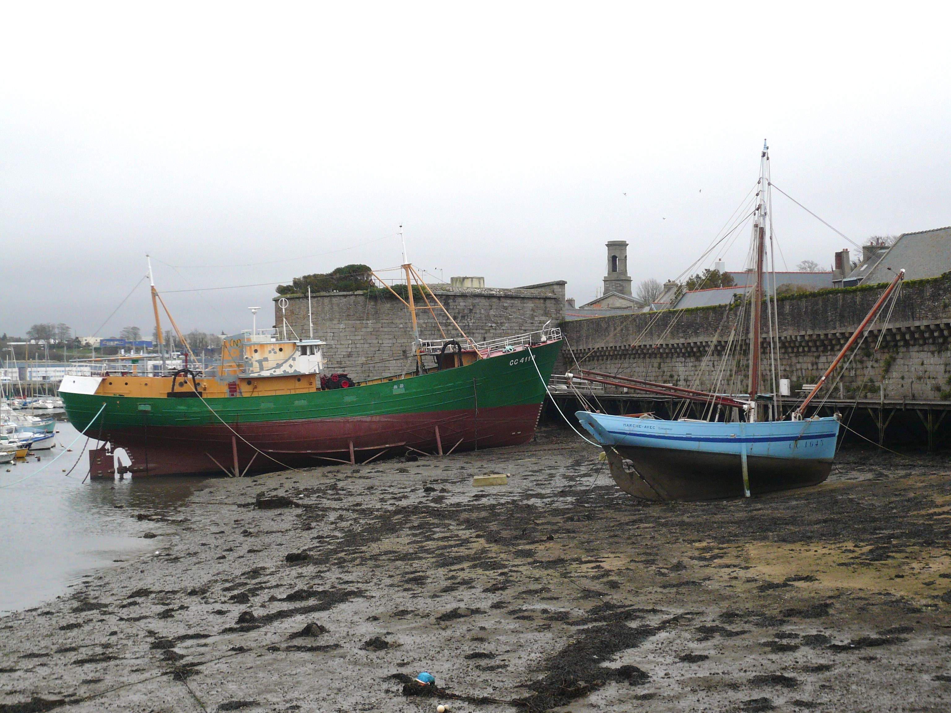
Hémérica, left, and Marche-Avec at low tide in March 2014. The supports and access structures make preservation’s shore connection visible. This is not an asserted Quai Suisse berth or evidence that the museum is currently open. Photo: Yann Gwilhoù, Wikimedia Commons; CC BY-SA 3.0. Unmodified by publisher.

Preserving a boat also requires shore infrastructure
The vessel’s heritage dossier records the practical work needed to make Hémérica into a museum ship. Its 1985–87 rescue phase included an access structure, supports and a reconfigured entrance with a gangway. Later campaigns included restoration of the hull and changes to mooring arrangements. These are material interventions, not simply a change of label from working boat to exhibit. Patrimoine Maritime et Fluvial, Hémérica, technical testimony.
This provides a useful comparison with the Quai Suisse without making their functions identical. Both cases required designers to solve the passage between land and vessel. For the fishermen, a landing reserved for the ferry did not answer that need. For the museum, retaining the vessel did not by itself provide suitable public access. Maritime heritage includes these less conspicuous connections. The hull and the ramparts attract attention, but a ladder, gangway or landing surface determines how people can actually reach them.
Working access remains a design question
A regional announcement dated 31 August 2026 describes a newer arrangement on the Moros quays, elsewhere in the port rather than at the Quai Suisse. It reports temporary, adjustable separation of work areas and a marked pedestrian route, developed around access to vessels and the needs of port businesses. The authority also notes the proximity of the Ville Close and the need to integrate the installations into its heritage setting. This is the project owner’s account of the works, not an independent assessment of their performance. Région Bretagne, Quais du Moros inauguration, 31 August 2026.
The comparison returns attention to allocation of space. Public access and maritime work are not automatically opposites, but neither can their safe coexistence be inferred from an unobstructed view of the water. The Quai Suisse makes that issue historically specific: an apparently modest addition answered a landing problem that the fortified town’s existing opening did not solve. Its significance lies in adaptation rather than antiquity.
The museum evidence used here is published interpretation, not a report of a recent visit. Its official website announces closure for works from 3 November 2025. Read together, civic history, archival descriptions and museum records allow Concarneau’s waterfront to be understood without imagining it frozen at one date. The Ville Close’s maritime past is real; the practical means of reaching the water have repeatedly been remade. Musée de la Pêche, official closure notice on homepage, checked 27 October 2026.
Locate the town
For regional orientation, open a Google Maps search for Concarneau. This community-level search is not an exact building entrance, a verified walking route or permission to enter a workshop, museum or private property. Check the institution’s own current access information separately.