Free · France
Amboise: Loire quays and floodplain settlement
The opening in the flood wall
At the junction of rue Louis XII and rue de la Concorde, Amboise's riverfront history can be read through a small practical feature: grooves intended to receive removable wooden flood barriers. The municipal heritage account places these openings beside a surviving reminder of the 1856 flood. A street had to remain a passage in ordinary conditions, yet could also become an entrance for water. The barrier answered that conflict by making closure temporary. It is a history of an inhabited river edge, not a guide to operating barriers or judging whether a particular property is safe. Municipal river heritage leaflet
A boundary that could be closed
The same leaflet describes gaps in the protective wall along quai François Tissard on the Île d'Or, with markings to match barrier boards to their positions. This was a boundary with removable components, not merely continuous masonry. The island and the left-bank street junction should remain distinct: a shared principle does not establish one construction campaign or operating procedure. Their relationship is best understood as a comparison between two documented adaptations. Municipal river heritage leaflet
Old plans disclose a changed shore
The regional inventory's account of the port au Bois supplies a different kind of evidence. Plans from 1835 and 1848 showed a watering place downstream of the Amasse's mouth. The inventory says this was removed and replaced by the long inclined landing structure, probably during flood-protection works in the third quarter of the nineteenth century. Its reference to the municipal realignment plan O 210 identifies the documentary basis rather than leaving the date to visual guesswork. The word probably remains important: the attribution is an informed interpretation, not a quoted construction contract. The quay's current stone surfaces cannot simply be projected backwards into every earlier picture of Amboise. A place for approaching the water and works intended to resist flooding could develop together, changing the practical boundary between town and river. Regional inventory IA37005041
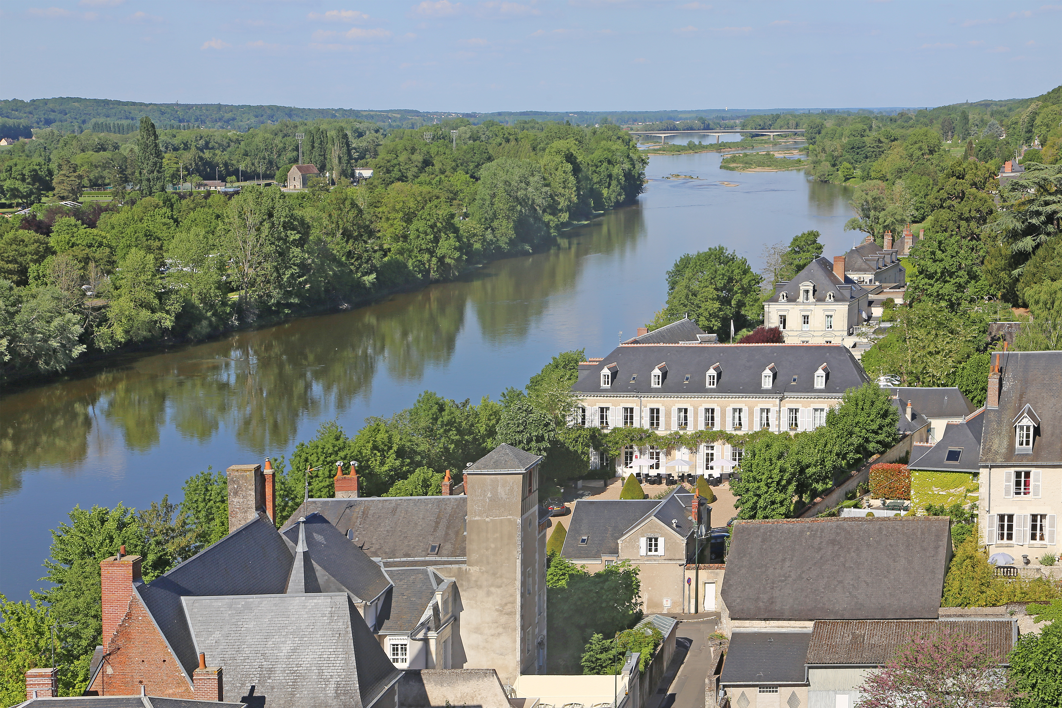
The Loire beside Amboise's built river edge, 8 May 2018. The view helps separate buildings, channel and island in the landscape; it does not establish surveyed heights, property flood risk or the condition of protective works. Photo: W. Bulach / Wikimedia Commons, CC BY-SA 4.0, original and rights record. Unaltered.

More than one source of water
The town's risk information identifies flooding from the Loire, the Amasse, or the two together. It describes a collection of protective works rather than a single embankment: walls with removable barriers, sluices and a diversion tunnel all form part of the historical response. That distinction changes the meaning of the street opening. Preventing water from crossing one threshold does not, by itself, explain what happens elsewhere in the network. Nor is the château an adequate proxy for conditions across the town. The municipal account distinguishes the island and lower banks from other parts of Amboise. A heritage reading must retain this uneven geography rather than present all residents as sharing one level of exposure. The page directs practical questions towards official risk information; the historical structures are not a substitute for it. Municipal account of major risks
The tributary behind the quay
Another municipal heritage leaflet locates the Amasse's outfall at the sluice behind Max Ernst's fountain. It traces the river's former open course from the quai des Marais towards the Tour Féalain. This helps explain why a riverside town cannot be understood from the broad Loire frontage alone. Some of its water arrives through the built area from behind that frontage. The leaflet also associates former tanneries with the Amasse, showing that the smaller river was a working resource as well as a management problem. These observations do not establish the complete underground drainage layout. They do establish a local connection between industrial occupation, channels and the quay. What may appear to be a decorative waterfront is also a point where inland water and the main river have to be considered together. Municipal account of the Amasse
A church records adaptation in its fabric
Across the river, Notre-Dame-du-Bout-des-Ponts gives a building-scale comparison. The city's historical account places the development of the suburb in the later fifteenth century, in a context of expanding trade and work on the levee. It records damage from the floods of 1846, 1856 and 1866, alongside persistent humidity and repeated repairs. Filled lower portions of windows are part of that account of alteration. This is not evidence that every house in the suburb was modified in the same way. It is a documented case of occupation continuing through repairs and physical adjustment. The church's accounts and requests for assistance also make adaptation a question of resources, not merely clever construction. Keeping a settlement usable involved choices about existing buildings and their costs, as well as the line of protection beside the river. Municipal history of Notre-Dame-du-Bout-des-Ponts
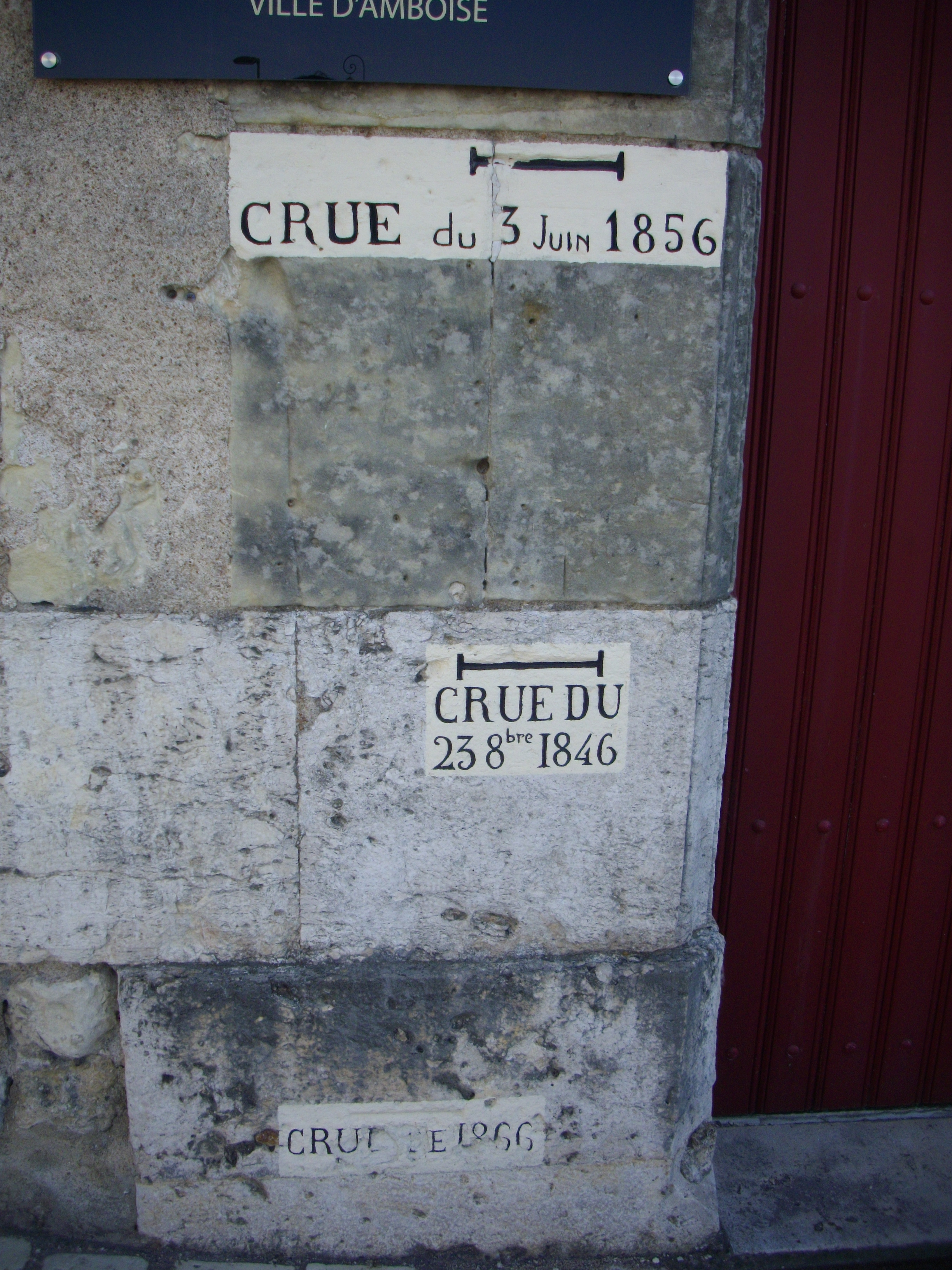
Flood marks at Notre-Dame-du-Bout-des-Ponts, photographed on 21 May 2017. These dated lines belong to the church site; they are not the left-bank bridge gauge discussed below, and do not measure water depth inside an arbitrary house. Their visible condition here is a dated observation, not a present-day inspection. Photo: Fab5669 / Wikimedia Commons, CC BY-SA 4.0, original and rights record. Unaltered.

Flood marks are records with conditions
The national flood-marker platform lists the gauge site upstream of the Maréchal Leclerc bridge on the left bank. Its entries distinguish the dates of floods, the nature of the marks and their recorded condition. Not every historical mark in the database is still visible: the entries for 1866 and 1907 are recorded as disappeared, while the 1856 mark has a later condition update. A catalogue of remembered water levels is therefore not a promise of what an observer will find on a particular day. Nor should a numbered gauge reading be confused with the depth inside a house. The value of the register lies in preserving location, reference and condition together. It makes the apparently simple act of pointing to a line on a wall more exact. National flood-marker record
Maintenance changes the story
The municipal magazine of December 2022 reported work to restore barrier closures at rue Marcel Nay and avenue de Tours. It stated that the southwestern protection system had been out of use for more than thirty years and described new road-width concrete foundations and fittings for removable supports. These are different openings from the historic rue Louis XII example, but they expose the same dependence on readiness. The article is evidence of reported works at named places, not certification that every component of Amboise's defences was functioning in October 2026. Its account also complicates a comfortable heritage narrative: a protective structure may survive while its operational condition changes. The continuing town depends on repair decisions and practical work that are less visually prominent than the surviving old walls. December 2022 municipal magazine, page 11
The occupied island needs services too
The council record of 26 February 2016 connects Île d'Or's embankments with planned gas, water, electrical and lighting works. Because those interventions affected the dikes, the partners required a stability study, supplemented by topographic and geotechnical investigations. The recorded decision authorised an amended funding arrangement. It does not establish that every proposed work was subsequently completed. Nonetheless, it shows why floodplain settlement is not simply a choice between buildings and empty land. Existing occupation entails service networks, and work on those networks has consequences for protective infrastructure. The street surface can conceal this interdependence. Reading the council record alongside a visible barrier opening reveals how the river edge is maintained through decisions shared by several bodies, rather than by masonry alone. Council record, pages 53–55
Responsibilities also have a history
An official management-transfer list dated 16 May 2024 names the Amboise-Amasse Centre Aval and Centre-Ville systems under the Communauté de communes du Val d'Amboise. This administrative evidence belongs beside, rather than inside, the history of construction. A stone wall can remain in place while responsibility for its management changes. The list is not a survey of its condition and does not establish who carried out a particular repair described in an earlier magazine. It does make clear why a dated municipal report cannot automatically be treated as a complete account of present responsibilities. Following an inhabited floodplain requires attention to institutions as well as structures. Official transfer list reproduced by INERIS
A museum view is not a flood model
The local museum guide describes two nineteenth-century representations of Amboise: Justin Ouvrié's river view of 1847 and Auguste Regnier's nocturnal view of 1845. The latter is explicitly presented as romantic and idealised. Such images belong in this story because they show how the riverfront became an object of attention and memory. They do not supply reliable elevations for calculating water movement through a street. Their proper comparison is with the kinds of questions asked by plans and marker records. The museum preserves selected appearances; the inventory follows alterations; civic documents disclose maintenance. Keeping those purposes distinct allows the quay to remain both a cultural landscape and a working boundary without forcing one source to answer questions it was not made to address. Municipal museum guide
The grooves beside rue Louis XII thus lead beyond a single remembered disaster. They reveal a persistent practical compromise: people need routes to and along the river, while an inhabited low-lying town also needs ways to interrupt water's movement. Amboise's quays record that compromise through alterations, removable parts and documented maintenance. Their history is neither the conquest of the Loire nor an unchanging accommodation with it. It is the continued work of making a particular riverfront usable, with limits that historical beauty cannot remove.
Location orientation
Amboise, France — general map search. This town-level orientation is not a verified entrance, accessible or flood-safe route, property-risk assessment or current operating instruction.
Source register and editorial gaps
Sources opened on 27 October 2026. Original English prose; no operating thresholds or property-specific advice.
- River heritage leaflet C — street and island barrier openings. Two opening sections share this source.
- Inventory IA37005041 — field inventory and published archival-plan interpretation; construction dating remains qualified.
- Municipal risks page — water sources and infrastructure; simplified zoning language not reproduced.
- Heritage leaflet B — Amasse course, outfall and working uses.
- Church history — built adaptation and historical funding needs.
- National marker register — location and condition fields; no numerical elevations reused.
- December 2022 magazine — page 11, reported reinstatement work.
- February 2016 council record — adopted study/funding arrangement, not completion.
- Museum guide — curatorial description of river paintings, not independently inspected originals.
- INERIS official transfer text — dated administrative allocation, not operational assurance.
Gaps and controls: original municipal plan O 210 was not inspected; its linked image notice failed to load. FranceArchives BB 12 returned an error and is excluded. The prefecture's PPRI page returned 502 twice and its approved-note PDF also failed; no parcel zoning or legal permission is asserted. The earlier 2011 risk attachment failed too. PDF screenshot attempts failed; text was readable and no visual measurements are claimed. A June 2016 municipal flood account opened with damaged text encoding; its event narrative is not used. A 2022 heritage-event notice opened but is not needed for the body. No present barrier inventory, maintenance log, engineering certification, current access inspection or representative resident testimony was obtained. The matching boards are historical description, not instructions to deploy defences.