Free · France
Montrésor: Renaissance château and Indrois village setting
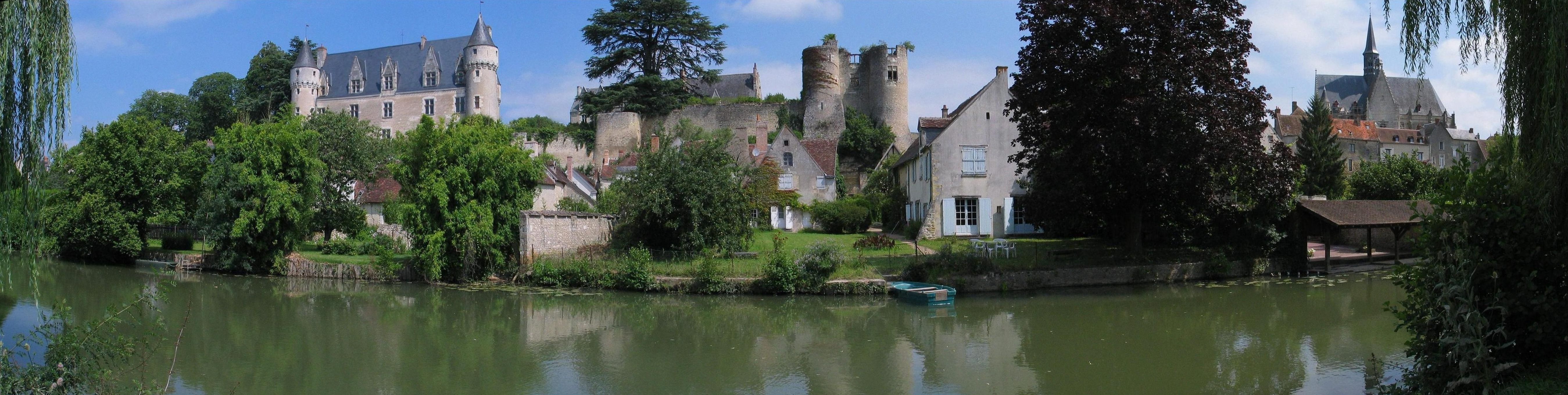
Two ways of looking across the Indrois
Montrésor's château is not best understood as an isolated Renaissance object. Its distinctive setting emerges from a pair of viewpoints: looking down from the enclosed grounds towards the village and river, and looking back from the riverside towards the buildings above. The official village discovery leaflet describes the Balcons de l'Indrois as a route from which the château, fortress, collegiate church and washhouse can be understood together. Its separate labels for fortress and château are useful. They prevent the entire silhouette from becoming one supposedly uniform building. The same leaflet identifies the surviving main residential wing within the older fortifications. From this starting point, the riverbank is more than a pleasant foreground. It provides a different scale of reading, bringing the great residence into relation with other buildings and routes. The subject is that relationship, not a checklist of monuments to visit. Official village discovery leaflet
Montrésor seen from the south bank of the Indrois, from photographs dated 14 July 2007. The photographer combined five frames into this panorama. It shows the relationship between the skyline and riverbank, not a survey of distances or present access.
Photo: JLPC / Wikimedia Commons, Montrésor Bords de l'Indrois.jpg, CC BY-SA 3.0. The photographer's stitched original is reproduced without further cropping or alteration.

A Renaissance residence inside an older frame
The Ministry of Culture's château record distinguishes several campaigns. It dates a major reconstruction for Jean IV de Bueil to 1393, naming the entrepreneur Jean Binet, and records acquisition by Ymbert de Bastarnay in 1493. The new residence occupied the existing fortified site rather than replacing its entire defensive framework. The record says that only the central part of a formerly longer residential building survives. This makes the silhouette a product of loss as well as construction. Its account of the nineteenth-century intervention also includes restored enclosure walls and changes to the château's exterior. Thus Renaissance describes an important phase, not an assurance that every visible surface belongs to it. A viewpoint across the valley compresses these episodes into one image; the written record separates them again. That contrast is central to understanding why a coherent-looking château can contain an uneven and interrupted architectural history. Monuments historiques record, PA00097876
The château's own interpretation similarly presents medieval, Renaissance and nineteenth-century phases, but gives particular attention to the experience of its furnished rooms and romantic park. It dates the park's redesign to the second half of the nineteenth century. The trees and sculptures therefore belong to a later way of arranging the residence and its surroundings, not automatically to the first Renaissance household. This distinction changes the meaning of the view from above. Looking out over the Indrois from a planted pleasure ground is not the same activity as surveying approaches from a defensive enclosure, even when both use the same advantageous height. The owner's presentation helps explain the intended atmosphere of the present heritage site. It should be read as an account of the place's accumulated character rather than as a claim that the garden preserves a complete sixteenth-century design. Château interpretation of its history and park
Terraces organise the view
The Comité des Parcs et Jardins de France describes gardens within the fortress walls and terraces arranged on four levels, including an orangery and winter garden. These are specific spatial features, not simply adjectives such as romantic or picturesque. Terracing makes a sloping site usable in stages and offers successive relationships with the surrounding landscape. The enclosed garden can feel separate from the village while remaining visually connected to it. The committee's description also emphasises the variety of outlooks available at different levels. That is a helpful way to read the setting: there is no single definitive château view, because height and position alter what can be seen together. This architectural reading does not establish that every terrace is currently accessible or that the directory's practical information remains valid. It concerns the organisation of the grounds, not a proposed visitor itinerary or a claim about an unchanged planting scheme. Comité des Parcs et Jardins de France: Montrésor park
Below, the view towards the château also has a history of management. The CAUE37 architectural and landscape diagnosis explains that open meadow preserves views, while growing vegetation can frame or obscure them. It also records nineteenth-century street-alignment schemes, including the partially implemented 1891 plan for rue Branicki. These two kinds of evidence belong together: the village's appearance is shaped both by building interventions and by changes in planted ground. A façade facing a street need not reveal the full age of the structure behind it, just as a leafy riverbank need not reproduce an earlier working landscape. The diagnosis draws on building survey and documentary research; its references to alignment plans are not plans independently examined here. Nevertheless, it gives a grounded alternative to the idea of a village frozen in time. The familiar panorama has been repeatedly made, altered and selectively kept open. CAUE37 architectural and landscape diagnosis, pages 26 and 40
Why the church belongs in the same picture
The nearby collegiate church is not merely another attractive roof beside the château. Julien Noblet's archaeological-atlas study places Montrésor among Touraine's castle-associated churches founded for dynastic remembrance. At Montrésor, the arrangement included privileged access to seigneurial chapels beside the choir through lateral passages. This gives architectural substance to the relationship between residence and religious foundation. The link was not just that the same patron paid for two handsome buildings; the church organised movement and differentiated spaces for the founding family, clergy and other worshippers. From the riverbank, those distinctions are invisible, but the shared skyline reflects institutions with different functions. Reading the church beside the château therefore makes the view more informative without turning it into a general account of Renaissance France. The important scale remains local: adjacent buildings and the arrangements through which one household sought to preserve its position and memory. Julien Noblet, Archaeological Atlas of Touraine
The church's national heritage record provides a complementary material description. It identifies a cross-shaped plan ending in a polygonal apse, with decorated lateral chapels and richly carved capitals. Portrait-like figures, heraldry and varied ornament appear within its account of the sculptural programme. These details show how a building's meaning can be carried by surfaces and internal divisions that disappear in a distant view. The riverbank perspective establishes proximity; the architectural record supplies differences. Neither should replace the other. Nor should the church be treated as simply an extra room of the château: its liturgical spaces and its separate institutional history require their own terms. Holding the two scales together allows the village setting to become legible without collapsing all its buildings into the biography of one owner. The exterior grouping is coherent, but the uses behind that grouping are not identical. Monuments historiques record of Saint-Jean-Baptiste, PA00097877
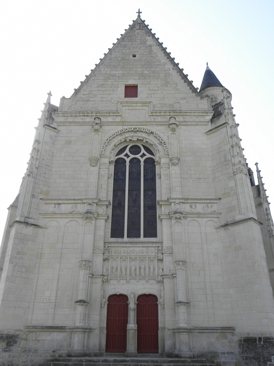
The collegiate church's west façade, photographed on 22 August 2011. This closer exterior view complements the river panorama; it does not show the interior chapels or lateral passages discussed in the architectural sources.
Photo: GO69, Montrésor (37) Collégiale Saint-Jean-Baptiste 01.JPG, CC BY-SA 3.0. Original photograph reproduced without cropping or other alteration.

A later interior behind the Renaissance name
The Ministry of Culture's account of the château's 2025 Maisons des Illustres recognition foregrounds Xavier Branicki's nineteenth-century residence. It describes the decoration as Second Empire and notes the library and paintings housed there. This institutional interpretation is a useful corrective to an expectation created by the word Renaissance. A visitor-facing historic interior can preserve the choices of a later household inside an older building. That is not a failure of authenticity; it identifies the period to which the furnishings and collecting story principally belong. The recognition also concerns the transmission of a person's memory, a different emphasis from a landscape diagnosis or an architectural inventory. These sources are consequently complementary rather than interchangeable. The château can be understood as residence, collection-bearing interior and major element in the village view without assuming that those identities all originated together or that every object has remained in one position since acquisition. Ministry of Culture, recognition announced in April 2025
The village is not just a foreground
The municipality's own description makes a further distinction between the displayed château and its continuing residential uses: it identifies the former service buildings as the family's home. It also places the market hall, washhouses and riverside features within the village's account of itself. These are not evidence that all earlier livelihoods continue unchanged. They do show why a view composed around a château should not make the rest of the settlement disappear. Domestic occupation and civic activity are different from the interpretation of historic rooms, even when they sit close together. The contrast is especially useful at a small site, where an impressive monument can dominate descriptions far more completely than it dominates the range of everyday uses. The village setting is meaningful because it contains such differences, not because every house or riverside feature can be made to illustrate the château's Renaissance phase. Municipality's account of local places and uses
The municipal history page openly introduces the treasure-finding lizard story as legend. Its place in local storytelling need not be confused with evidence for the château's construction. Legend gives a memorable explanation of a name; inventories, surveys and institutional accounts answer different questions about buildings and their uses. This distinction offers a fitting way to return to the Indrois view. Montrésor's appeal does not depend on proving that the whole scene belongs to one enchanted moment. It lies in the relationship between a fortified site, a later residence, a planted prospect and an inhabited village. Looking up from the water and down from the terraces reveals the same place from different positions. Reading the evidence alongside those viewpoints makes its layers clearer, while leaving the charm of the setting intact. Municipality's history and explicitly labelled legend
Source register and editorial boundaries
All ten sources were opened on 27 October 2026. Inline links identify the evidence for each paragraph; interpretation is distinguished from physical or documentary findings.
- Official bilingual village discovery leaflet, page 1: distinct buildings and riverside interpretive route. Parsed text read; map image not successfully rendered.
- Ministry of Culture, POP PA00097876: construction phases and surviving fabric. Relative wording about demolition dates not converted into an unsupported exact date.
- Château de Montrésor, Art et Histoire: owner's presentation, particularly park chronology.
- Comité des Parcs et Jardins de France: terrace organisation. Practical information not adopted.
- CAUE37, Montrésor architectural and landscape diagnosis, printed pages 26 and 40: alignment history and managed views. PDF text opened; screenshot retrieval failed.
- University of Tours archaeological atlas, notice 205, Julien Noblet: spatial relationship between residence and collegiate foundation.
- Ministry of Culture, POP PA00097877: church plan and ornament. No attempt to reconcile its precise construction date with the atlas's chronology of individual parts.
- Ministry of Culture/DRAC, 8 April 2025: nineteenth-century interpretation and announced recognition. Not an object-by-object collection inventory.
- Municipality, Que voir ?: continued residential uses and civic presentation.
- Municipality, 2000 ans d'histoire: explicitly labelled local legend; no claim of historical treasure discovery.
Remaining gaps: No original construction accounts, Branicki household inventory or street-alignment plan was examined. Archival comparison is mediated through the official inventory and CAUE documentary research. A national photographic record and the atlas PDF could not be fetched; no unviewed image is described. The local association's large riverside-panel PDF exceeded the tool's retrieval limit and was not used. No present terrace-access guarantee, conservation-condition judgement or claim that all village buildings are Renaissance is made.