Free · France
Albi: Brick cathedral and Tarn river trade
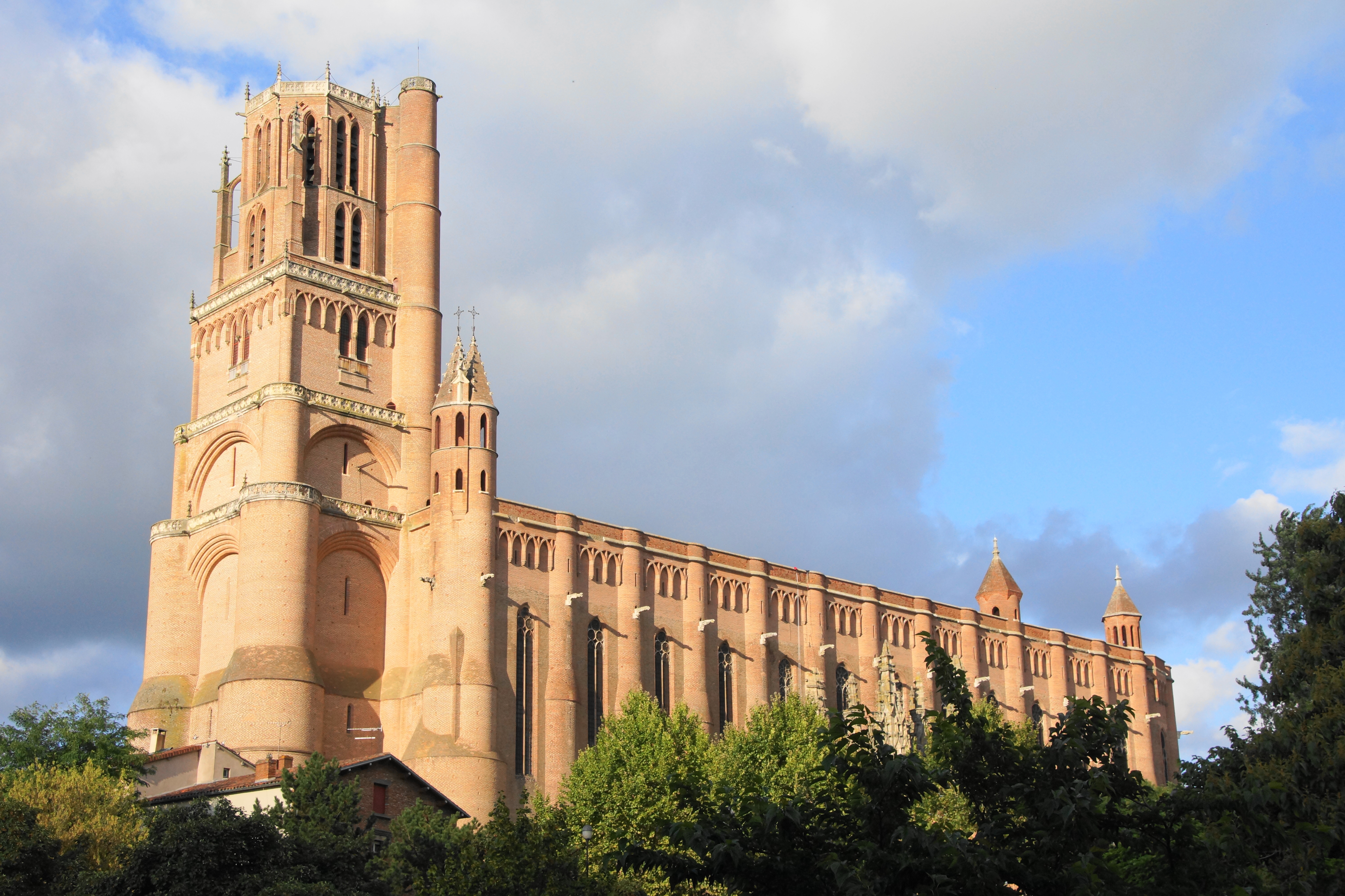
Albi's cathedral and river are often fitted into the same photograph. They should not automatically be fitted into the same explanation. Sainte-Cécile expresses religious authority through a monumental building; the Tarn and its crossings reveal the practical problem of moving people and goods. To connect them responsibly, distinguish the city in which power was displayed from the networks through which trade operated. A view across water is a beginning, not evidence that river profits paid a particular building bill.
The most revealing feature is the relationship between height and movement: the cathedral and episcopal palace above the river, the bridge carrying traffic across it, and the difficult waterway below. Each offered a different advantage and imposed different constraints.
Brick gives coherence, not a single construction date
UNESCO's description of the Episcopal City of Albi emphasises the visual coherence created by locally fired brick and the relationship among the cathedral, palace and surrounding historic neighbourhoods. The property was inscribed in 2010. Its recognised value concerns an urban ensemble, not simply an isolated church, and the brick tradition continued across a long period. UNESCO: Episcopal City of Albi.
That is why colour alone cannot date a façade. Two surfaces may look related while belonging to different campaigns, uses or repairs. Read a material as a clue to investigate, not a calendar. A photograph also compresses distance: structures that seem to form one wall from across the river can have separate histories and functions.
A useful first observation is to name the element before interpreting it: cathedral exterior, palace wall, bridge arch or domestic frontage. Then ask which source dates that element. This modest discipline prevents “the medieval brick city” from flattening centuries of change into a single scene.
Sainte-Cécile: an exterior and an interior making different impressions
The official tourism account dates the cathedral's principal building campaign from 1282 to 1493 and identifies its Southern Gothic character. Its massive appearance contrasts with the elaborate painted and sculpted interior. The Renaissance vault decoration is dated to 1509–1512, while a carved stone enclosure separates the nave and canons' choir. A predominantly brick monument can therefore contain important work in other materials and from later periods. Albi Tourisme: Sainte-Cécile.
For interpretation, separate three questions. What supports the building? What distinguishes spaces within it? What communicates through imagery? They need not have the same answer or date. Calling the cathedral a “fortress” may convey the exterior's impression, but that analogy should not replace an account of its religious use.
Nor should the size of the building become a shortcut for explaining how it was financed. Establishing a specific payment, donor or revenue stream requires relevant documents. The sources used here support the importance of episcopal authority and commerce in the city; they do not justify attributing the entire cathedral to one commodity or trade route.
Material coherence is not one building phase. Rob Stoeltje’s 19 September 2013 photograph shows Sainte-Cécile’s exterior and tower. It is a dated view for comparing brick surfaces and forms, not evidence that every element was constructed simultaneously or financed by one trade. Photo: rob Stoeltje, Flickr original, CC BY 2.0. Original photograph unchanged.
The river view was also a view from a seat of power
The Musée Toulouse-Lautrec's account of the Berbie describes a medieval episcopal residence strengthened with towers and defensive walls, including walls descending toward the Tarn. Later bishops transformed the complex into a more comfortable residence. The museum also documents decorated medieval floor tiles discovered within the palace. These are reminders that a severe exterior could enclose spaces of ceremony and display. Musée Toulouse-Lautrec: the Berbie palace and gardens.
The interpretive value of the riverside setting is not merely that it makes a good viewpoint. It raises questions about access, separation and visibility. Which direction does a wall close off? Which parts of the town can be seen from an elevated position? These are observation questions, not a claim that every visible detail had a single defensive purpose. Garden terraces and later residential alterations must not be projected unchanged into the thirteenth century.
Crossing the Tarn was not the same business as travelling along it
The departmental archives' educational dossier explains that the river could be difficult to navigate and that roads were often preferred. It places the construction of the Pont-Vieux between 1035 and 1042, while identifying its oldest presently visible parts as thirteenth-century work. Initially, the crossing was too narrow for carts, so loads moved on people or animals. The dossier also locates former market space near the cathedral, linking the upper city to exchange rather than treating it as exclusively religious ground. Archives départementales du Tarn: Ville et Patrimoine—Albi.
This is the central geographical distinction. A bridge makes movement across water possible; a navigable channel permits movement along it. Improving one does not automatically solve the other. A trader might need both, or might choose a road because the river was unsuitable. Avoid drawing every commodity's route as a smooth line down the Tarn simply because the town stands beside it.
When looking at the bridge, imagine the practical question rather than a fictional procession: how could a load fit through the available space? What would have to be carried, transferred or broken into smaller units? Answer only as far as the historical evidence allows.
A working waterway had friction
The Tarn archives' account of navigation describes flat-bottomed wooden gabarres, seasonal changes in water level and difficult passages. It names regional cargoes such as Carmaux coal, pottery, glass, grain and Gaillac wine. Upstream movement could require hauling, often by people, rather than simply reversing a downstream voyage. The same account describes competition from rail and the river's removal from the navigable classification in 1926. These are features of the wider river economy across different periods, not a cargo manifest for one Albi boat. Archives départementales du Tarn: navigation and gabarres.
The list is useful when read as a set of questions. A heavy bulk cargo creates a different handling problem from fragile pottery. A downstream delivery and an upstream return require different effort. A route's commercial importance can change when another mode becomes more dependable. None of that can be measured from today's water surface alone.
This article does not present a single transport time, load capacity or uninterrupted route as typical of all centuries. Those would require a dated journey record and a defined stretch of river. A general heritage account can explain the problems without supplying that level of precision.
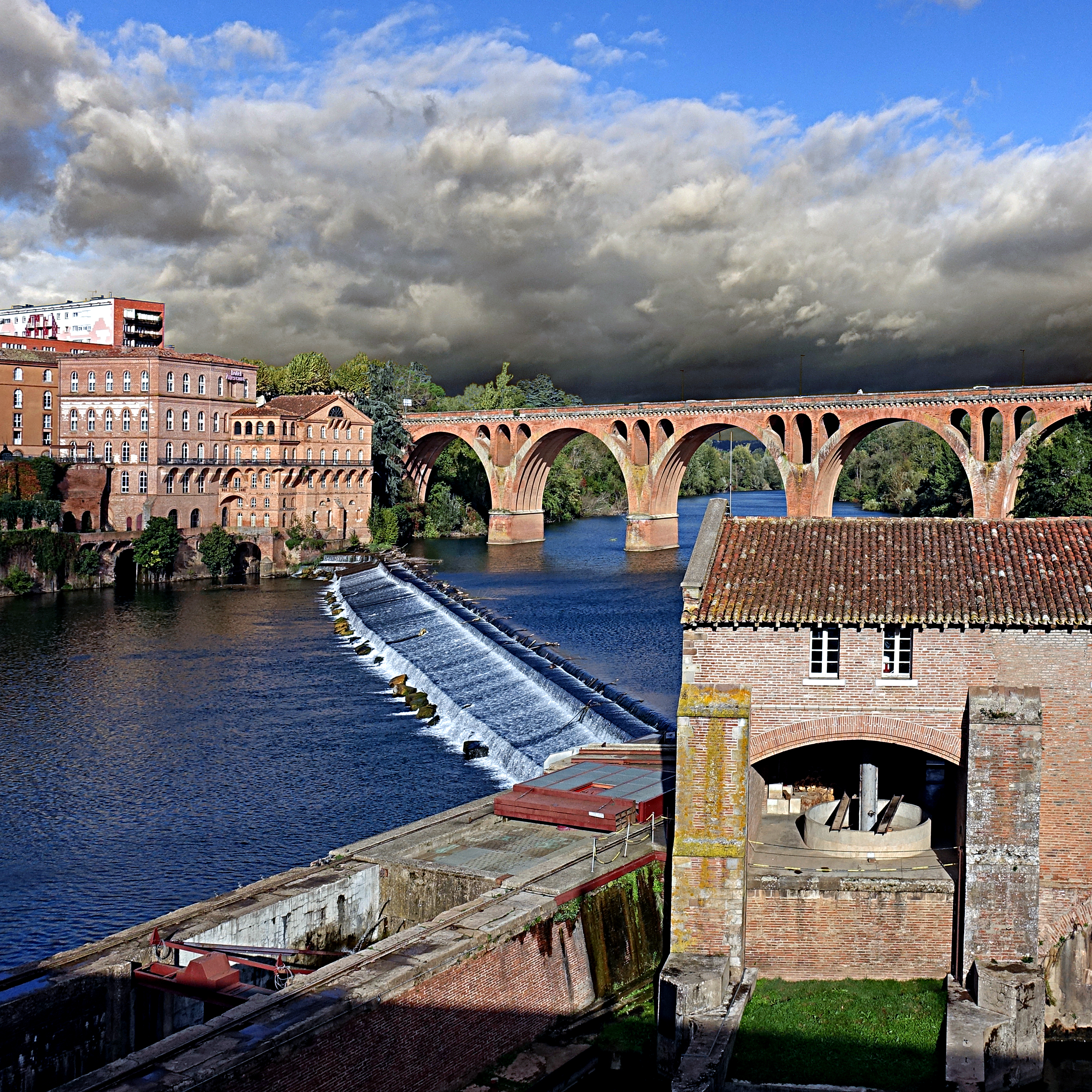
Look along the water, not just across it. This 4 November 2022 view from the Pont-Vieux shows the Tarn, a weir and riverside buildings. The bridge visible beyond is not the Pont-Vieux from which the photographer looked. The scene helps distinguish a crossing from the obstacles in a watercourse; it does not document a historical cargo journey, safe navigation or the bridge’s later restoration. Photo: pom’, Flickr original, CC BY-SA 2.0. Original photograph unchanged; adaptations must retain applicable share-alike terms.
The bridge visible today includes later decisions
The city's historical presentation describes a medieval bridge with a fortified entrance, chapel and drawbridge, and later houses on its piers. Those houses were removed after the 1766 flood; the roadway was straightened and widened in 1820. The familiar crossing is therefore not an untouched eleventh-century object. City of Albi: Pont-Vieux history.
For present conditions, a more specific municipal project page supersedes the older page's lingering statement that restoration is under way. It reports completion at the end of May 2025 and reopening to traffic on 10 June 2025. The work included waterproofing and paving, masonry repairs and enlarged pedestrian space. It describes one-way motor traffic from the centre toward La Madeleine. This was checked again remotely on 28 October 2026, not confirmed through an on-site journey. City of Albi: completed Pont-Vieux restoration.
That source comparison is part of reading a living heritage site. A historical page can remain useful for the past while containing obsolete access information. Conversely, a current works page can explain today's layout without being a complete history of the bridge. Use each for the question it actually answers.
A compact comparison without inventing a trade story
Make three entries in your own notes, whether visiting or reading remotely:
| Element | A supported question | A conclusion to avoid | |---|---|---| | Cathedral exterior and interior | Which construction or decorative phase does the source identify? | Every visible feature belongs to the initial campaign. | | Pont-Vieux | What crossing capacity or alteration is documented for a specified period? | Its present width represents medieval traffic conditions. | | River and former trading activity | Which cargo, direction and period does the source describe? | Every regional product passed this exact point by boat. |
Add a fourth line for the connection you can actually defend. “The city combined a powerful episcopal centre with river-crossing and commercial functions” is different from “this cargo financed this wall.” The first is a synthesis of the evidence discussed here. The second requires a particular financial or building record that has not been supplied.
The resulting story is less convenient than a single cause, but more useful. Albi's brick monuments and river trade belonged to the same urban world without being reducible to one another. Reading them together means preserving that relationship—and its limits.
Orientation, worship and current arrangements
Use this map search for Sainte-Cécile, Albi for broad orientation. It is not a surveyed walking route or a checked accessibility plan. Consult current local notices before using riverbank paths or planning a crossing.
The cathedral remains a place of worship. Its visitor information distinguishes general access from paid areas and says visits do not take place during celebrations. The museum's practical information separately lists garden and collection arrangements: access to the gardens should not be treated as admission to every interior room. Check the relevant institution rather than assuming that one ticket or opening schedule covers the whole episcopal ensemble.
Source register and limits
Remote primary/institutional research used UNESCO, municipal history and restoration notice, official tourism, Tarn archives educational resources and the local museum. No on-site observation, boat journey, original cargo ledger or cathedral building account was inspected. Educational publications are not newly examined medieval documents. General cargo information is not attributed to one boat or year. Prior institutional PDF verification is retained; renewed retrieval returned HTTP403, so no fresh PDF inspection is claimed.