Free · France
Eguisheim: Concentric streets and the logic of an Alsatian wine village
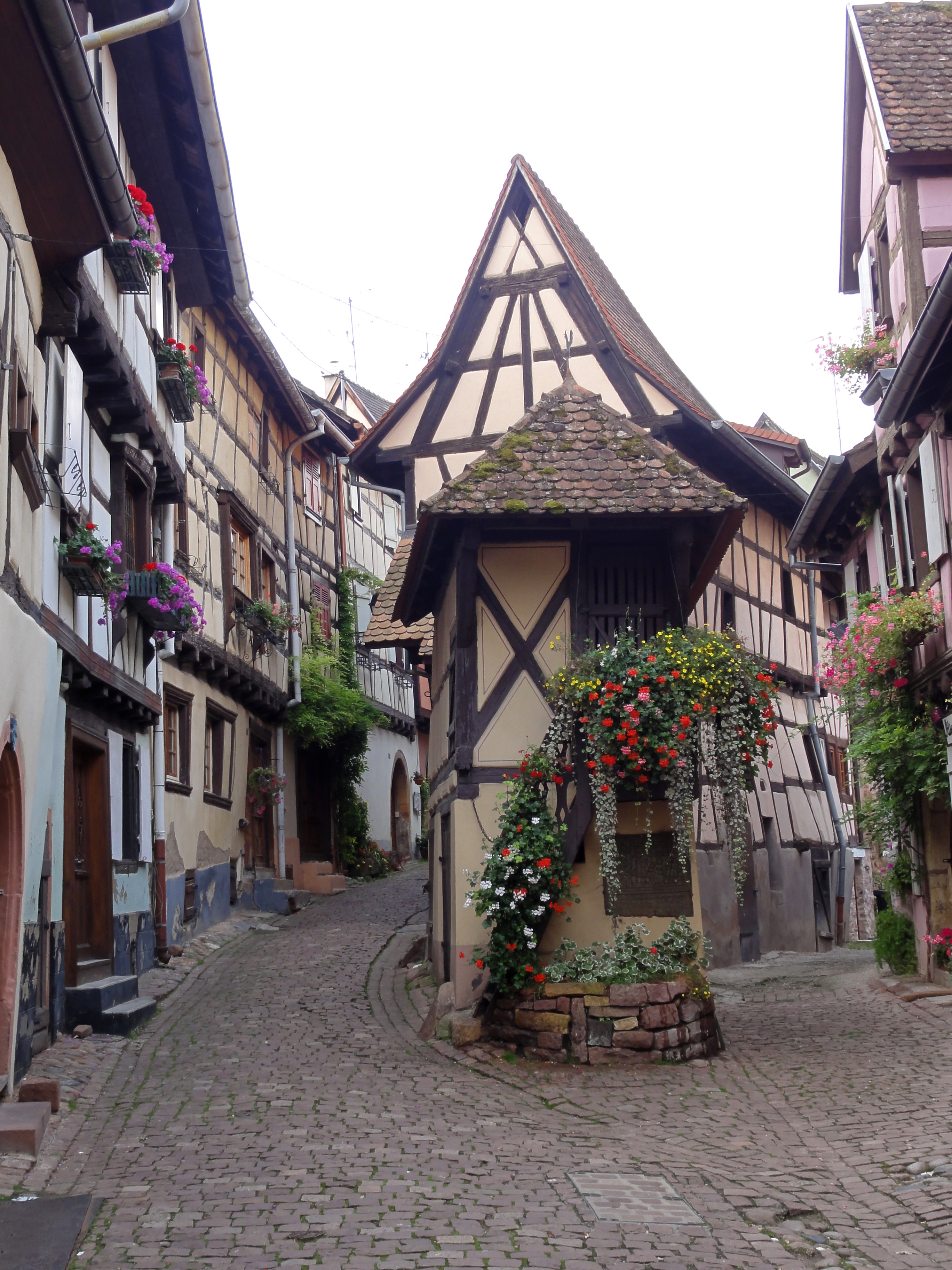
A street pattern made for more than walking around
Eguisheim's curved streets invite a simple explanation: a village grew in circles around a castle and remained that way. The first half describes a recognisable arrangement; the second obscures how much happened inside it. The useful question is how an enclosed settlement continued to admit people, connect buildings and accommodate ordinary work. Its street plan answers through the relationship between the rings and the routes crossing them.
The rue du Rempart Nord, rue du Rempart Sud and the Allmend passages belong to that enquiry, alongside the Grand-Rue that cuts across the centre. Read together, they reveal different kinds of movement within a small area. A continuous-looking perimeter does not mean every journey followed its curve. Nor does a surviving alignment make its buildings, surface and uses equally old. The municipal planning report distinguishes the main cross-village axis from the smaller streets attached to it. Eguisheim PLU, January 2019, p. 69.
Rue du Rempart-Sud and rue de l’Almend-Sud on 15 September 2014. Their relationship is visible at street level; the photograph does not date the lanes or establish the age of every building.
Photo: © Ralph Hammann - Wikimedia Commons, Eguisheim rRempartSud a1.JPG, CC BY-SA 4.0. Original photograph reproduced without cropping or other alteration.

What an old plan can actually show
The Archives d'Alsace preserve a particularly useful starting point: Eguisheim's 1828 village sheet, cote 3P 598. The digitised image is labelled Section F, the town section. Its plan shows nested, rounded bands of building plots enclosing a less regular interior. A route crosses the enclosure, and buildings already extend beyond the rounded core. These are observations from the image, not a reconstruction of a medieval founding scheme. 1828 cadastral village plan.
The distinction matters. An early nineteenth-century plan establishes that a configuration existed by then; it cannot by itself date every line to the thirteenth century. The enclosing shape is also less mechanically regular than the phrase “concentric circles” suggests. The bands bend around a compact settlement, while the interior contains differently shaped blocks, interruptions and open spaces. Geometry describes an overall tendency, not a rule obeyed by every wall.
The archive's own research guide explains that the Napoleonic cadastre was created for taxation. Its usefulness comes from recording land and buildings systematically rather than selecting the prettiest view. Its limits follow from the same purpose: a parcel plan does not tell us how frequently a particular doorway was used, who carried a load through it, or whether a route was congested at harvest. Those require other evidence. Archives d'Alsace, guide to the cadastre.
The central castle has its own boundary
The castle at place du Château-Saint-Léon must be distinguished from the enclosure around the settlement. The regional environmental authority describes the castle and chapel on an octagonal fortified platform, within a town characterised by a double concentric fortification. These are related boundaries at different scales, not interchangeable names for one wall. DREAL Grand Est, village heritage sheet.
Municipal history places the town's development around the castle and records its occupation by the episcopal bailiff until 1752. The centre was therefore associated with local authority as well as enclosure. That helps explain why it matters to the settlement's organisation, without proving that someone laid out every surrounding street in a single operation. The same account records violence and disruption, including the sack of 1444 and the hardships of the Thirty Years' War. Its story hardly supports an untouched architectural survival. Municipal history.
The local historical society adds a later sequence: the castle ditch was drained in 1835; nineteenth-century works repaired the enclosure and introduced the chapel, consecrated in 1894. Those changes altered the central setting long after the defensive framework originated. The national monument record, PA00085414, is more precise about protection than about a complete building biography: the castle's enclosing wall was classified on 27 March 1903. A protected component should not be mistaken for a guarantee that everything around it belongs to the same period. Local society's castle history; castle protection record.
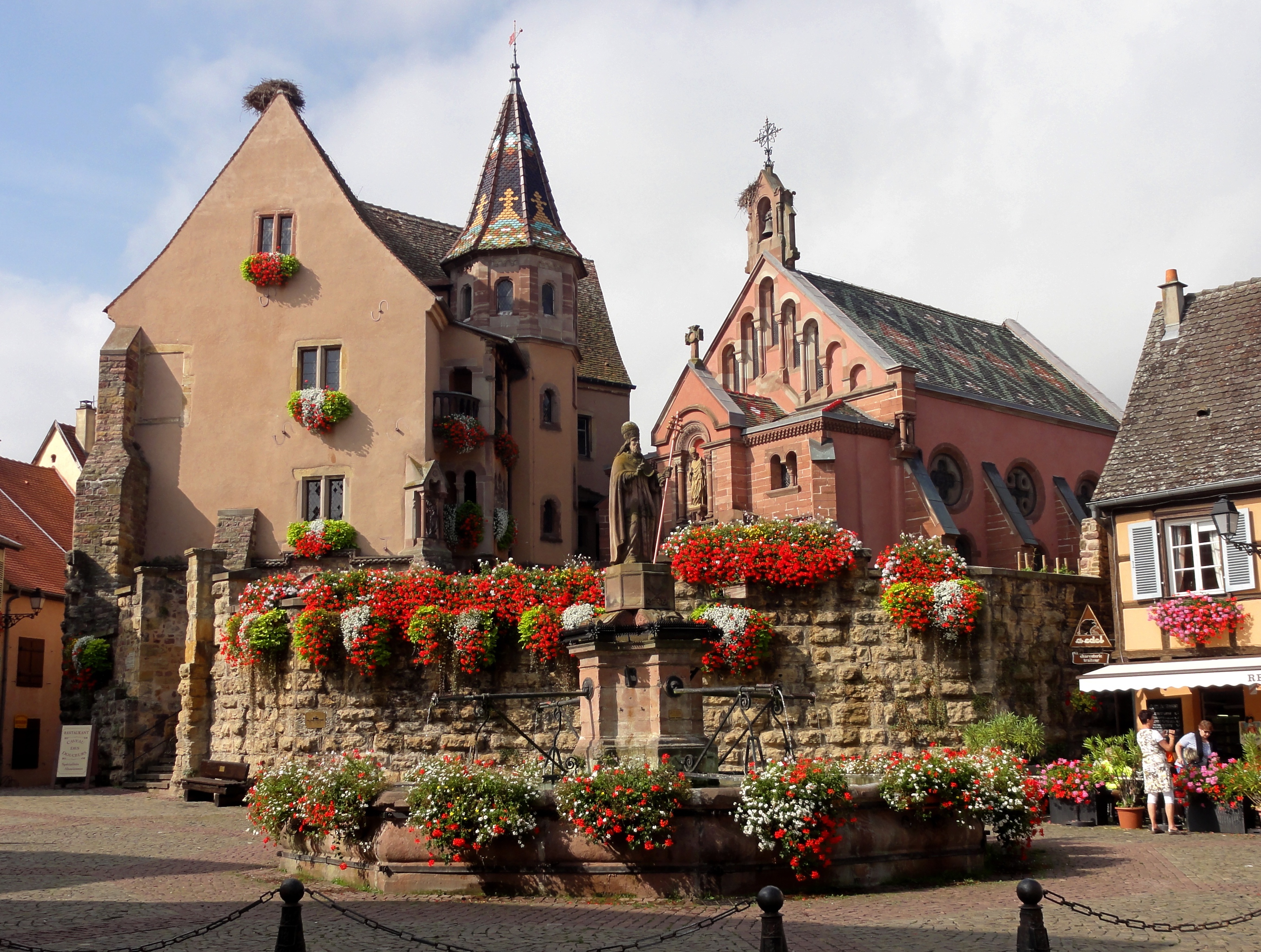
Castle, chapel and fountain on 15 September 2014. This central ensemble includes later architectural layers; it should not be mistaken for a uniformly medieval scene or for the village’s outer enclosure.
Photo: © Ralph Hammann - Wikimedia Commons, Eguisheim ChâteauStLéon 01.JPG, CC BY-SA 4.0. Original photograph reproduced without cropping or other alteration.

Crossing the rings
Grand-Rue provides the necessary correction to a view of Eguisheim as a sequence of loops. The planning report identifies it as the east–west structural axis joining the Untertor and Obertor, with smaller streets branching into the built fabric. The practical implication is straightforward: routes around the perimeter and routes towards destinations inside it had to coexist. The outer curve alone cannot explain access to the centre.
Even the municipality's substantial planning document needs care as historical evidence. Its account gives 1257 for enclosure on page 63 but refers to eleventh-century ramparts on page 66. That inconsistency prevents treating either passage as a definitive construction date. The report is more dependable here as an analysis of the street relationships it maps than as a resolved chronology of the defences. Municipal PLU, pp. 63, 66–69.
Gate imagery offers another kind of evidence. The Société d'Histoire et d'Archéologie d'Eguisheim publishes drawings of former gateways, including a tower shown from its outward and inward sides. The caption identifies that drawing as a trial reconstruction based on incomplete documents. It is useful for imagining a substantial building over a confined opening, but it is explicitly not an untouched contemporary survey. Historical society, gate drawings.
That qualification does not make the drawing worthless. It directs attention to the question a gateway raises: how could a boundary restrict access while allowing necessary passage? A closed defensive perimeter and an inhabited village required openings. The streets leading to them deserve as much attention as the curved streets that make the plan memorable.
A working connection across the street
One address supplies unusually concrete evidence of how a perimeter lane functioned. The national inventory entry IA68003541 concerns the former farm at 19 and 21 rue du Rempart Sud. Surveyed in 1994, it records a dwelling with a window dated 1687 and dependencies across the street with an arched doorway dated 1624. It also identifies doors opening towards the Allmend, which the description associates with the enclosure ditch. Inventory record for 19–21 rue du Rempart Sud.
The important point for street history is the arrangement across and behind the buildings. Related premises occupied opposite sides of a public route, while another opening connected to the Allmend side. Movement was not simply lengthwise around a ring. The layout also required crossings and access between distinct parts of a working property. That is a spatial inference from the documented arrangement, not evidence for a particular cart route or a daily timetable.
The dates provide another useful restraint. Seventeenth-century building elements participate in the familiar street scene. Their presence does not date the street itself, but it does show why “medieval village” is too broad a description of everything visible along it. The enclosure, the route and the premises beside that route have separate histories.
Water and the limits of a picturesque lane
Public space also had to accommodate water. On Grand-Rue, the national record for the fountain dated 1557, PA00085418, identifies construction campaigns extending beyond the sixteenth century. Even a conspicuous landmark can contain several periods. A fountain occupies and organises street space differently from a continuous frontage: it makes a place to stop within a route used for passing through. That reading concerns the arrangement of public space, not an assertion about an undocumented queue or market. Grand-Rue fountain record.
For the northern ring, the historical society's account of the August 1949 fire preserves evidence that the attractive street surface was not timeless. Its photographic captions describe the Rempart Nord in 1911 with an earth surface and water running down the middle, then lateral drainage channels in 1937. The same article records Bernard Haumesser's recollection that the narrow Allmend access hampered firefighters approaching from the other side. This is identified testimony within a retrospective local account, not a measured emergency-access study. Local history of the Rempart Nord fire.
The account dates the completion of the neighbourhood's reconstruction to after 1960. The persistence of the ring therefore cannot stand for complete continuity of the buildings along it. In an emergency, moreover, the close spacing that gives a lane visual coherence could become a practical limitation. A useful history of the street must make room for both experiences.
A museum street offers a contrasting explanation
At the regional Écomusée d’Alsace, a street arrangement has a different documentary explanation. Museum designer Marc Grodwohl recalls how a change of visitor entrance disrupted his intended sequence through reconstructed buildings. He then used a fortified house and its enclosure to redirect movement, with a new street passing around it. This is his first-person account of museum design, not evidence that Eguisheim developed in the same way. The comparison makes a useful distinction: apparently old buildings can frame a deliberately assembled modern route. In Eguisheim, the cadastral plan and property records instead establish relationships within an inhabited historic settlement. In both cases, entrances and crossings matter; appearance alone cannot identify their chronology or purpose. Grodwohl, museum layout and circulation.
Preserving a relationship rather than a frozen scene
DREAL's heritage sheet records the village ensemble as a site inscrit from 14 May 1970, covering 7.13 hectares. Its emphasis on the urban ensemble helps explain what survives at the larger scale: the relationship among the central fortified site, enclosing bands and closely built streets. This designation is distinct from the castle wall's individual monument protection. DREAL village sheet.
Eguisheim becomes more intelligible when those relationships are read alongside changes in use and fabric. The cadastral plan fixes an early nineteenth-century configuration; the building inventory identifies a specific crossing relationship; local photographs and testimony recover conditions that the present street does not display. None alone supplies the whole history. Together they explain why the curves endure without requiring a story in which the village stopped changing. Its street pattern is the framework within which successive generations continued to move and work.