Free · France
Veules-les-Roses: Fishing heritage around village lanes
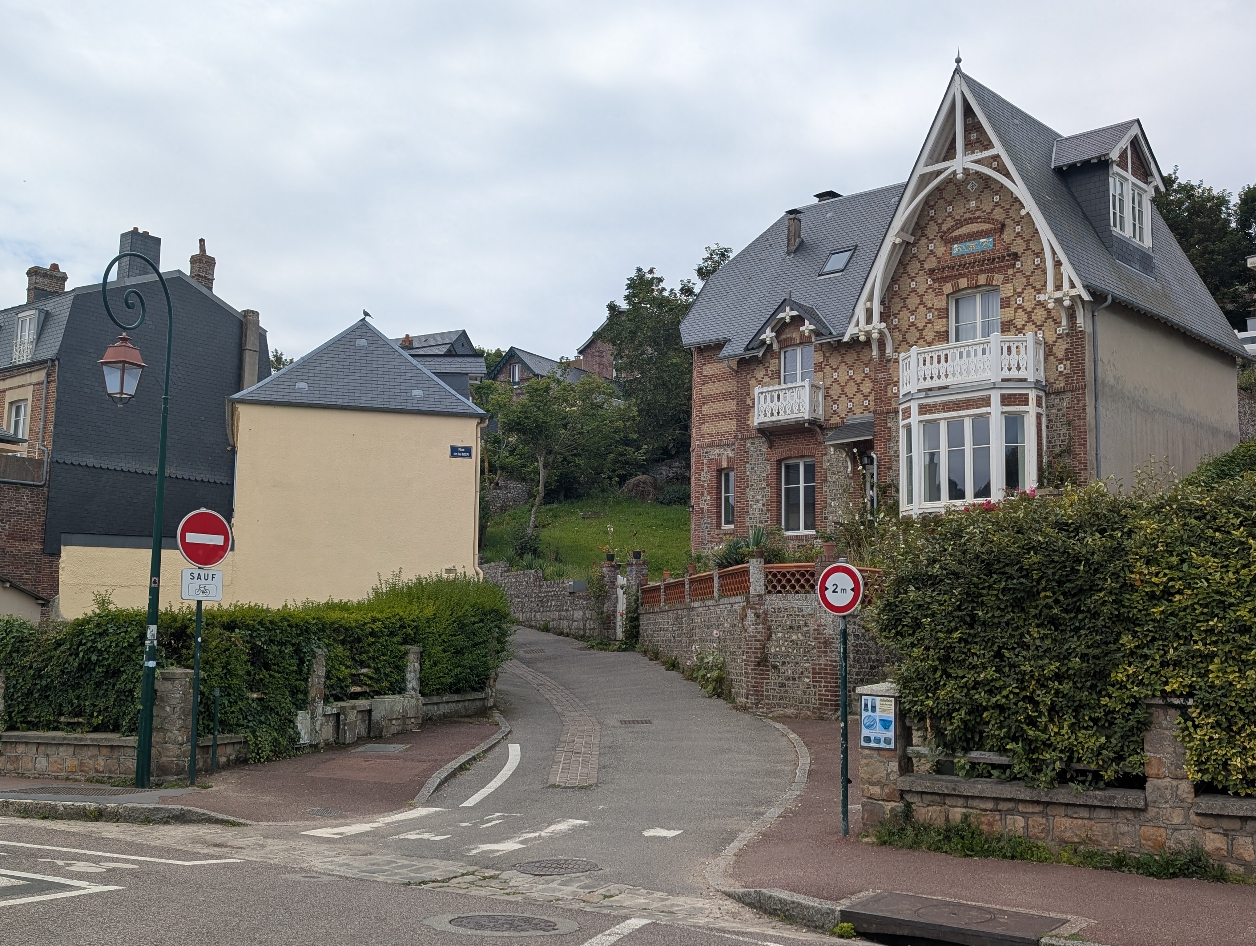
A lane leading towards the sea is not necessarily a street of fishermen's houses. In Veules-les-Roses, that distinction matters particularly around the rue de la Mer. The narrow feature examined here is its place in the connection between the village's historic market area and the waterfront. Fishing heritage can be approached through that relationship without assigning an occupation to every old doorway. Read together, the records suggest a street landscape in which maritime work, everyday exchange and seaside residence overlapped, rather than a surviving enclave that can safely be labelled a fishing quarter.
The entrance to rue de la Mer in August 2025. The visible street plate identifies the lane; the houses and paving do not identify past residents’ occupations or prove an unchanged route for fish sellers. Photo: Андрей Романенко, Wikimedia Commons; CC BY-SA 4.0. Unmodified by publisher.

The market and the shore were connected through the village
The planning diagnostic approved in November 2022 describes a main street running between Saint-Martin church and the sea, parallel to the river. Another route, identified with the rue Eugène Manuel and rue de la Mer, passed through the market alongside it. The same historical section, credited to the Association pour la Sauvegarde du Patrimoine Veulais, describes rows of houses sometimes backed by a second row, with a small court between. It draws on historical land records, but those original records have not been inspected for this article. Veules-les-Roses, PLU diagnostic, printed p. 48, PDF p. 52.
The resulting picture is more useful than a sequence of attractive façades. There was a connection through a place of exchange, with a distinction between the public street and spaces behind its frontage. That is a reason to investigate circulation as well as buildings. It is not evidence that every courtyard held nets, or that fish followed one exclusive route inland. Neither use should be supplied simply because it would make the scene more vivid. The historical connection is established more securely than the occupations of individual premises.
A record of destruction interrupts the picturesque view
An archival document reproduced in Veules's heritage-planning report makes the fragility of that built setting tangible. The permission to collect charitable relief, dated 11 July 1781 and identified as Archives départementales de la Seine-Maritime, 2H460, describes a fire during the night of 6–7 July. It lists lost houses, furniture, linen, provisions and merchandise. The reproduction has been read; the original archival file has not. Veules-les-Roses, AVAP presentation report, p. 10, included in the 2022 planning annex.
The report also reproduces a reconstruction of the town in 1781. Its accompanying explanation expressly calls it an estimate assembled from written documents, not a precise contemporary plan; the final extent of the fire towards the sea is uncertain. This makes it unsuitable for declaring which present house escaped. It does, however, prevent an easy equation between an old street alignment and an untouched collection of buildings. A route can outlast major losses along it. The material history of the lane and the history of its course need not move together. AVAP presentation report, pp. 8–9.
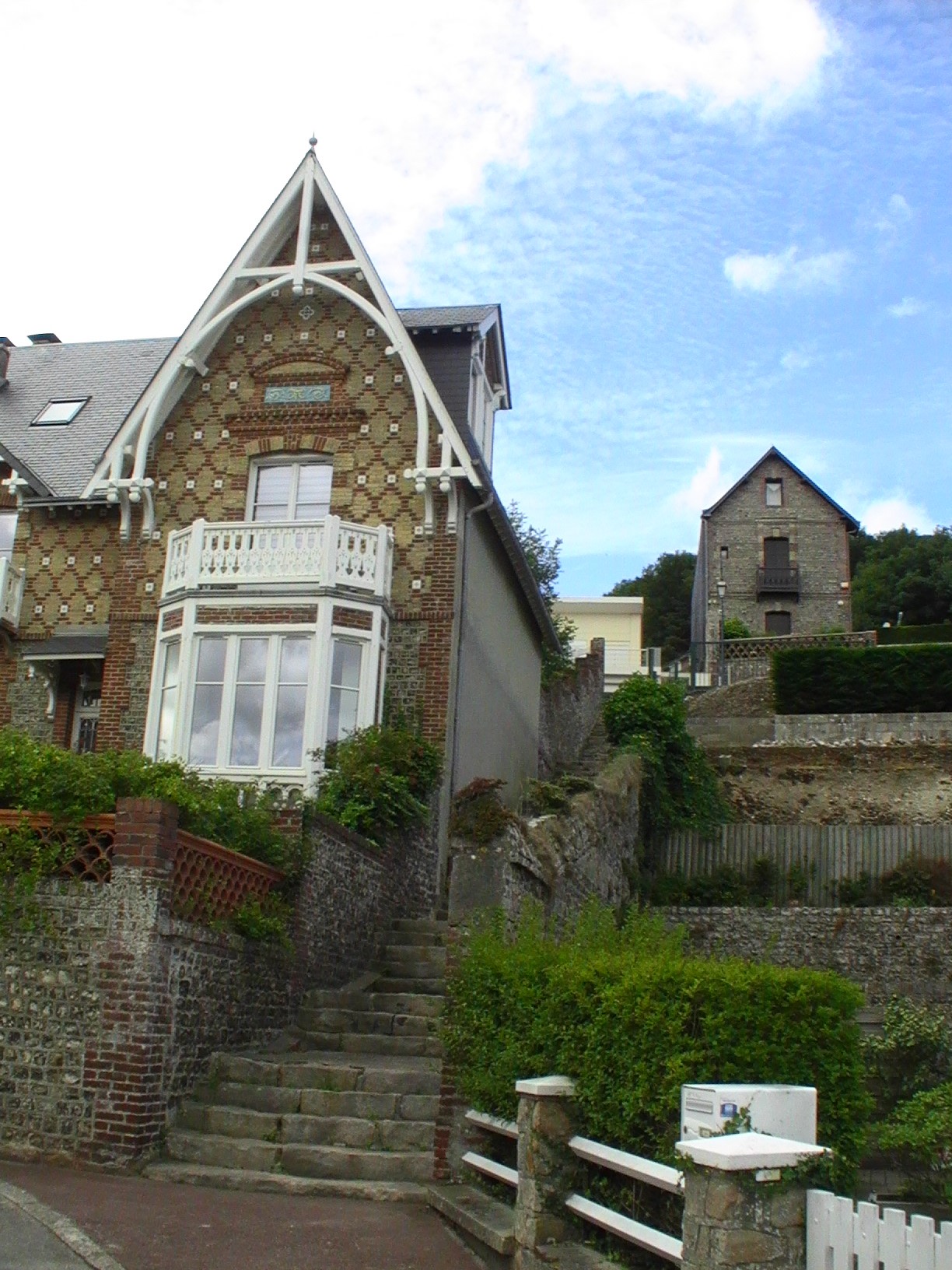
Part of villa Mondésir, at left, in July 2017. The dated exterior view supports comparison with the inventory’s seaside-villa classification, not an account of current ownership or fishing households. Photo: Totorvdr59, Wikimedia Commons; CC BY-SA 4.0. Unmodified by publisher.

One address belongs to the history of seaside residence
At 2 rue de la Mer, the national heritage inventory identifies a seaside villa called Mondésir. The record dates its principal construction campaign to the second half of the nineteenth century. It describes brick and flint masonry, a slate roof and decorative ceramic and woodwork, and records a garden as an unstudied component. These are findings from the 1986 inventory survey, not a report on the property's condition or ownership today. Inventaire général, Villa de bord de mer dite villa Mondésir, IA00054447.
This single address changes the question asked of the street. A sea-facing location could serve residential enjoyment as well as maritime employment. Brick and flint alone cannot decide between them. The inventory's classification is evidence for the villa's building type; it does not identify the occupations of everyone who lived there. A description of fishing heritage should preserve this difference rather than recruit every coastal building into the same story.
Local historical publishing reinforces the need to distinguish these layers. The heritage association's presentation of Marie Jamet's 2023 study of Veules's seaside architecture describes a selection of twenty-six villas supported by archival documents. The publication announcement, rather than the complete book, was consulted here. Its declared subject places substantial residential development within the village's history, not outside it as a modern intrusion into an otherwise uniform fishing settlement. Association pour la Sauvegarde du Patrimoine Veulais, Publications.
Holiday visitors could also become customers
The arrival of seaside residents need not be narrated as the straightforward replacement of fishing by leisure. An official nineteenth-century source describes an economic connection between them. The Ministry of Marine and Colonies' statistics for 1874, published in 1875, name Veules alongside Saint-Valery-en-Caux, Étretat, Yport and Fécamp among resorts attracting bathing visitors. In its discussion of the Fécamp maritime district, the report says that this seasonal custom brought some material benefit to the maritime population: coastal catches could be sold locally at remunerative prices, while opportunities for work increased. Ministère de la Marine et des Colonies, Statistique des pêches maritimes 1874, printed p. 25, PDF p. 13, institutional scan held by VLIZ.
Its tables concern the wider district, not Veules alone; it identifies neither a stall on this lane nor a particular household. Yet it supplies a contemporary reason not to separate fish sellers from holidaymakers. Visitors might become customers rather than simply displace an older livelihood. The same report describes fishermen's material situation as precarious. Seasonal sales and economic insecurity could coexist: increased custom did not necessarily mean secure livelihoods.
The seaward end has its own chronology
The nineteenth-century setting was itself vulnerable. The tourist office's village history records destruction on 11–12 June 1940, particularly affecting the seafront during the German advance. This is an account of the waterfront area, not a damage assessment for individual addresses on the rue de la Mer. Office de Tourisme de la Côte d'Albâtre, Veules-les-Roses.
For the lane's interpretation, the important distinction is between reaching the shore and finding the same shore-side buildings there. The historical route should not be treated as a transparent corridor into an earlier town. Its destination has a history of rupture as well as use. Maritime heritage may therefore require attention to missing structures, not only surviving ones. Establishing the position of an old selling place would need dated evidence from before and after that break. Today's relationship between street, beach and trade is worth examining in its own right, rather than presenting it as a surviving photograph of the nineteenth century.
The waterfront remains a place of exchange in civic descriptions
The Côte d'Albâtre tourist office's 2023 leaflet maps the rue de la Mer separately from rue Victor Hugo, with both approaching the seafront. Its text describes Veules fishermen setting nets and pots offshore and selling their fish from waterfront stalls. The map confirms the named street's position; the text identifies a working use of the waterfront. It does not establish that the modern stalls occupy an eighteenth-century fish market. Office de Tourisme de la Côte d'Albâtre, Veules-les-Roses heritage leaflet, 2023, pp. 1–2.
This makes the sea end of the lane more than a viewpoint in the village's public presentation. It leads towards an area where fishing products can enter ordinary commercial exchange. The connection is spatial, not proof of an unbroken business lineage. A visitor route and a selling place may share the waterfront while serving different purposes. Treating the stalls as work rather than decorative evidence of tradition also leaves room for changing equipment, sellers and customers.
A neighbouring municipality provides a less picturesque description. La Chapelle-sur-Dun's information page, read in October 2026, lists fish, crustacean and oyster sales at Veules, distinguishing the fisherman from the oyster grower. Its regional introduction makes availability conditional on weather and large tides. The undated page is a civic service listing, not a verified census of Veules's fishing workforce or a guarantee of today's trading. La Chapelle-sur-Dun, Marchés et pêche locale.
That qualification is part of the place's character. A waterfront stall depends on more than pedestrian access. Reading the street solely as an attractive approach to the beach would omit the conditions under which its maritime destination works.
A museum comparison with a firm geographical boundary
The regional museum evidence offers a different kind of precision. In its account of the doris Popaul, Les Pêcheries, musée de Fécamp, traces one boat through service aboard a trawler, later ownership and a loan for use as a fish-shop stall in Paris before its entry into the museum in 1981. The text explains that restoration sought to retain material rather than make it seaworthy again. This is documented Fécamp object history, not evidence of a boat or fishing household in the rue de la Mer. Ministère de la Culture, Doris, Doris, museum-authored account updated in November 2022.
The comparison is useful precisely because its identity and successive uses are documented. It shows what an occupational history needs beyond a recognisable appearance. No equivalent Veules-local museum record establishing this lane's fishing households was verified. That gap should remain visible, rather than be filled with Fécamp's boats or testimony.
The rue de la Mer can therefore be read as a connection, not an occupational label. Its relationship to the market and shore gives fishing a place within the village's built history; it does not make the entire street exclusively maritime. The strongest account allows rebuilding, seaside residence and the sale of catches to remain distinct. What links them is access to the same coastal setting, used for different purposes at different moments.
Locate the town
For regional orientation, open a Google Maps search for Veules-les-Roses. This community-level search is not an exact building entrance, a verified walking route or permission to enter a workshop, museum or private property. Check the institution’s own current access information separately.