Free · France
Veules-les-Roses: River, watermills and coastal settlement
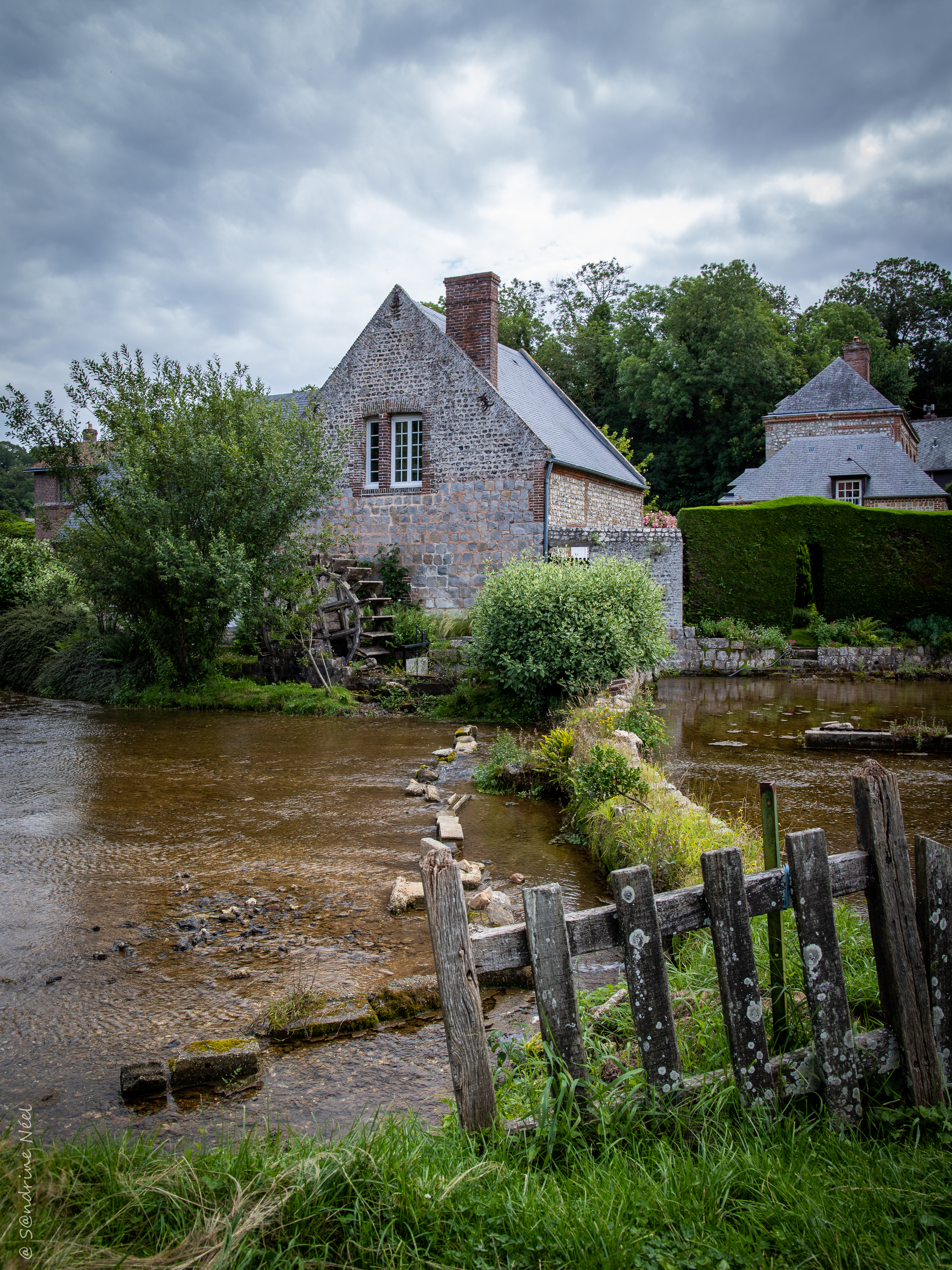
At the Moulin des Cressonnières, the most useful historical question is not simply whether a waterwheel turns. It is how a milling site fitted into the river, and what remained when the building acquired other uses. A wheel can survive without its former productive role. A house can retain the name of a mill while the water beside it continues to demand attention. This small site in Veules-les-Roses offers a way to examine coastal settlement from inland: through the relationship between a building, an engineered watercourse and the people occupying its banks, rather than through the beach or a catalogue of picturesque streets.
The mill beside the watercress beds in July 2021. Building, wheel and divided watercourse can be seen together, but the photograph does not date every component or demonstrate that milling continued. The photographer’s signature is retained. Photo: @ S@ndrine (Sandrine Neel), Wikimedia Commons; CC BY 2.0. Unmodified by publisher.

A building placed beside managed water
The commune's planning diagnostic, approved in November 2022, identifies the Moulin des Cressonnières as a wheat mill authorised by royal ordinance in 1823 but constructed by François Vattement in 1832. It places the building at the end of a dyke crossing the watercress beds. The account describes flint and brick construction, later residential use, and the initials F.V. with the date 1832 on the south-eastern gable. Its stated source is the municipal website. These are civic historical claims repeated in a secondary planning compilation, not findings from inspection of the original ordinance or the municipal website itself. Veules-les-Roses, PLU diagnostic, printed p. 68, PDF p. 72.
The difference between permission and construction matters. Calling this simply an “1823 mill” would conceal a nine-year interval. More importantly, the dyke places it within a worked waterscape. The relevant unit is not only a masonry shell: the connection to water belongs to the explanation of why a mill stood there. The gap between the two dates also leaves a question, rather than supplying a story. Nothing in this short civic account establishes why construction took that long.
The historical record is not a single frozen village
The national heritage inventory's collective record for Veules's mills, based on a 1986 survey, gives changing totals: four mentioned in 1785, seven in 1792 and ten in 1833. It dates the surviving watermills broadly to the eighteenth and nineteenth centuries. Those figures describe different moments, not the number of structures a person should expect to find today. They place the Cressonnières mill's recorded construction within an early nineteenth-century milling landscape rather than an undifferentiated medieval past. Inventaire général, Moulins, IA00054462.
The same inventory programme recorded a different mill on the chemin des Champs-Élysées. Its individual notice dates that building to the eighteenth century and its replacement vertical waterwheel to the nineteenth. This neighbouring example should not be used to date equipment at Cressonnières. Its value is comparative: even within a single milling site, a building and its machinery can belong to different campaigns of work. Inventaire général, Moulin, IA00054455.
Together, these records discourage the idea of an intact historic scene preserved all at once. Counting mills, dating walls and dating wheels are separate tasks. A photograph may bring them together visually, but historical explanation has to take them apart again. Otherwise, replacement and adaptation disappear from the story precisely where they might explain how a place endured. A repair is not necessarily a loss of historical significance. It may instead be evidence that someone invested in keeping an installation useful. Establishing that history requires attention to individual components rather than assigning the oldest available date to everything.
A short river is not a small relationship
The local river authority describes the Veules as approximately 1.1 kilometres long, with its source and mouth in the same commune, but a catchment of 23.5 square kilometres. Its account follows the river from the watercress beds between private gardens, then into a more confined channel beyond the RD142, bordered by walls and low walls. It notes variations in channel width at mill sites. This is a description of an occupied, engineered river. Syndicat Mixte des Bassins Versants du Dun et de la Veules, Rivières.
Length is therefore a poor substitute for an account of use. It tells us how far the visible river travels, not how its banks were occupied or how buildings related to its flow. At Cressonnières, the recorded dyke supplies a particularly concrete starting point. It directs attention sideways from the wheel towards the ground and water around it. This is also a more useful scale for understanding settlement than treating the coast as the village's only organising feature. A coastal place can have an inland working edge whose history is not primarily maritime.
The wheel and the house acquire different lives
A local horticultural publication provides a closer account of the site's later arrangement. In the 2023 Gazette des Parcs et Jardins, Charlotte Latigrat describes the garden of the Moulin des Cressonnières, with photographs credited to Chantal de Crépy. The article describes the wheel as municipal heritage property separated from the mill building, and identifies the remains of a millrace beside a planted terrace. It also states that the garden is not open for visits. This is the article’s 2023 description, rather than a present ownership check. Association des Parcs et Jardins de Normandie, Gazette 45, printed pp. 25–26, PDF pp. 27–28.
The important point is the separation of functions. An element presented as communal heritage sits beside a domestic setting, while the former hydraulic connection remains legible in a fragment of channel. This is not the same thing as keeping an entire production system in operation. Nor does residential adaptation make the older arrangement irrelevant. The millrace can still explain a relationship that the building's current use no longer makes obvious. Reading it that way avoids asking a surviving wheel to stand for every part of the mill's history.
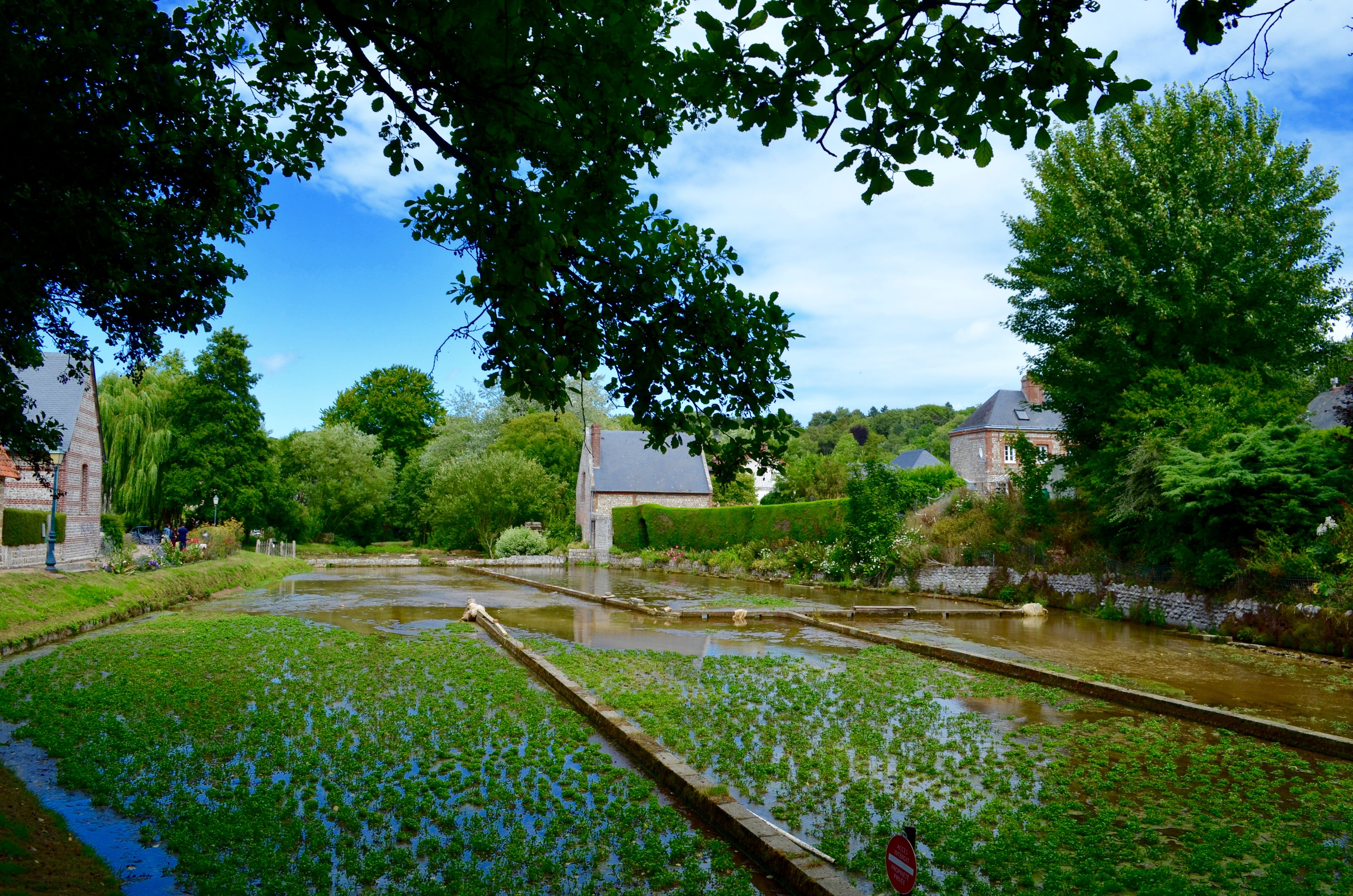
Watercress beds at Veules-les-Roses in July 2017. The cultivated compartments and adjoining buildings give the shared waterside setting a visible form; they do not establish shared ownership or a single mill-and-cultivation business. Photo: Roger Thurnill, Wikimedia Commons; CC BY-SA 4.0. Unmodified by publisher.

A museum title records a worked landscape
A dated museum object adds a different kind of evidence. The Rijksmuseum catalogues Carel Nicolaas Storm van 's-Gravesande's 1873 etching under the original title Moulin dans les cressonnières à Veules—a mill in the watercress beds at Veules. The sheet, on Japanese paper, entered the collection as a gift from the artist in 1902. The catalogue identifies Veules as its subject, but does not establish a cadastral address or a continuous machinery history. Rijksmuseum, RP-P-1902-A-22554.
The title is useful precisely within that limit: it records milling and cultivation together as a named subject in 1873, rather than treating the wheel as an isolated picturesque object. The civic diagnostic supplies the Cressonnières building's chronology; the museum catalogue supplies a dated representation associated with the cultivated landscape. Neither should be made to do the other's work. This is museum-held evidence about Veules, not a collection located in the village, and the print is not identified here as the present mill. Only the catalogue text was inspected; no visual analysis of the print is asserted.
The mill name and the cultivated beds
The word cressonnières refers to watercress beds, but the name should not turn the mill and the cultivation into a single enterprise. The tourist office maintains a separate listing for La maison du cresson de Veules, on the Chemin des Cressonnières. Read in October 2026, it describes winter production, sales on site and at local markets, and explanatory visits with tasting. It does not describe these as services supplied by the mill accommodation. Office de Tourisme de la Côte d'Albâtre, La maison du cresson de Veules.
That distinction changes how the surroundings should be read. Productive cultivation is not interchangeable with the landscaped garden of a converted mill, even when both contribute to an attractive riverside view. The watercress listing also places visitors within an agricultural business rather than outside it as spectators. For the milling site's history, the useful implication is modest but important: a change of use in one building does not establish that the whole waterside landscape has ceased to work. Nor does a shared place-name establish common ownership, a shared workforce or an unbroken business history.
Hospitality uses the setting differently
The Côte d'Albâtre tourist office's 2026 accommodation guide lists the Moulin des Cressonnières as a guest accommodation business. It places the rooms in two independent houses opening onto gardens and says that breakfasts are served in the mill. The guide identifies its information as supplied by tourism partners at the beginning of 2026. It therefore documents an advertised arrangement, not verified occupancy or income. Office de Tourisme de la Côte d'Albâtre, Hôtels et Chambres d'hôtes 2026, PDF pp. 4 and 14.
This supplies a specific example of reuse rather than a general claim that tourism replaced milling throughout Veules. The mill building participates in a service offered to overnight guests, while sleeping accommodation occupies other buildings. The old name gathers these elements together commercially even though their functions differ. A brochure cannot tell us whether that arrangement funded a particular repair, how much work it creates, or who performs every task. What it does show is that the site's economic identity is no longer described through the processing of grain. Its position beside the river has become part of the setting offered to guests.
The channel remains part of everyday management
The river authority's guidance on banks distinguishes ownership of the land and riverbed from the regulated use of water. It connects riverside maintenance with the passage of water, the condition of banks and aquatic life. That distinction is relevant to interpreting a former mill: having a house beside a channel does not make the channel an isolated domestic feature. The authority's page also illustrates works on the neighbouring Dun; those examples are not evidence that the same interventions occurred at Cressonnières. Syndicat Mixte des Bassins Versants du Dun et de la Veules, Aménager les berges.
A separate volume of Veules's 2022 planning report describes flooding associated with runoff and the Veules overflowing within the built-up area. Its account of potentially flooded land draws on historical information, including the June 1983 disaster declarations, and field observations. This is commune-level planning evidence, not proof that the Cressonnières mill itself was flooded. It nonetheless shows why the river cannot be understood only as heritage scenery. Buildings and water continue to share space under conditions that change. Veules-les-Roses, PLU environmental report, printed p. 25, PDF p. 28.
The milling site consequently belongs to two histories at once: the history of a productive installation and the continuing history of occupation beside water. At Cressonnières, permission, construction, machinery, garden use and hospitality do not share one date or one function. Keeping those distinctions visible makes the place more intelligible, not less coherent. The river is the connection between them. The mill's significance lies as much in that changing relationship as in the recognisable shape of its wheel.
Locate the town
For regional orientation, open a Google Maps search for Veules-les-Roses. This community-level search is not an exact building entrance, a verified walking route or permission to enter a workshop, museum or private property. Check the institution’s own current access information separately.