Free · France
Granville: Walled town, tides and island departures
A town understood through its entrances
Granville's maritime character becomes more specific when attention moves from the sea view to the places where passage is controlled. The Grand'Porte marks entry into the fortified upper town; below, boarding places connect the mainland with Chausey. These are not equivalent structures, and the gate did not operate as a ferry terminal. Read together, however, they suggest a useful question: who or what can pass, and under what conditions? The local history museum itself interprets the Logis du Roi, above the gate, as a link between upper and lower Granville. Musée d'art et d'histoire, history of the Logis du Roi
This is a history of thresholds rather than a catalogue of sights. A wall gives an entrance a defined position. A tidal harbour adds a changing condition: the available water. Following that distinction helps explain why an island departure belongs to the town's everyday organisation, not simply to its scenery.
The question is not whether a gate resembles a harbour entrance, but what each allows us to notice. An approach concerned only with appearances stops at the view. An approach concerned with passage asks about permission, timing and the work needed to keep a connection usable.
The gate is not a single historical moment
The municipal heritage account describes an upper town founded by the English in the fifteenth century, with fortifications subsequently built and rebuilt over several centuries. It places the Logis du Roi above a drawbridge gate overlooking the quays. That relationship is more useful here than treating every visible stone as a survival from the town's foundation. Ville de Granville, “Haute Ville”
The official descriptions do not supply a perfectly aligned chronology. The city's page labels the gate 1580–1640. The Ministry of Culture's architectural record instead associates the present Grand'Porte and the governor's lodging above it with the rebuilding of the ramparts between 1727 and 1749, following demolition in 1689. Without the underlying building studies, those dates should not be silently reconciled. Ministry of Culture, Mérimée PA00110421
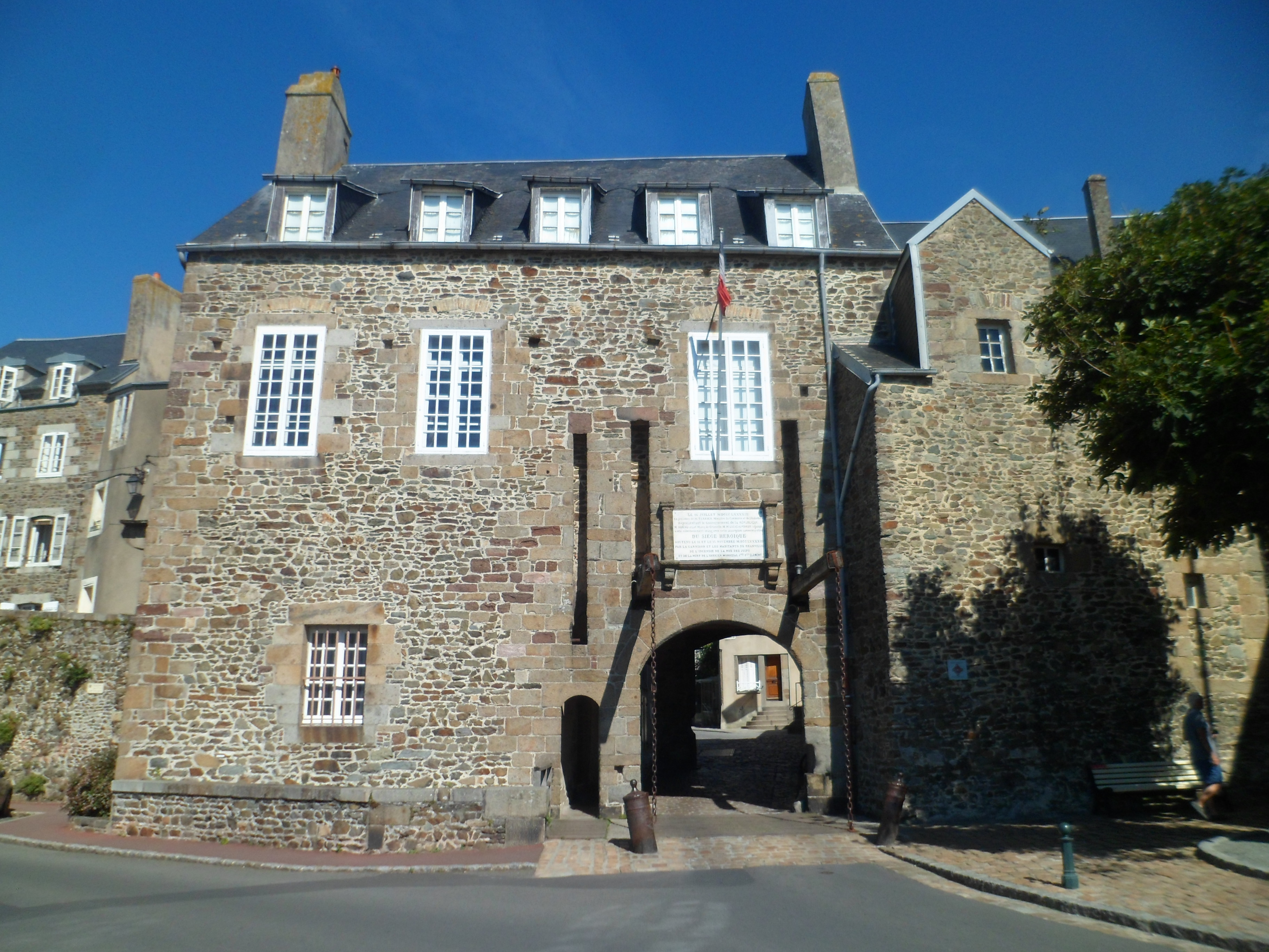
What survives the disagreement is the essential spatial arrangement: entry below, accommodation and authority above. The museum cautions that “Logis du Roi” expresses royal representation, not necessarily a king's visit. Its account also stresses alterations responding to military needs. The threshold was an adaptable piece of urban equipment before it became an object of heritage interpretation. Musée d'art et d'histoire
The Grand’Porte and the Logis du Roi in August 2012: passage below, rooms above. The photograph illustrates their spatial relationship; it cannot resolve the conflicting construction dates in the official accounts. Photo: HaguardDuNord, Wikimedia Commons; CC BY-SA 3.0. Unmodified by publisher.

Looking down is not the same as taking part
The upper town's elevation can make the port look like a complete picture. A locally held artwork makes that relationship unusually clear. In January 2024, Granville's museums announced the acquisition of Paul Signac's watercolour of the town, dated October 1922. Their description identifies the Haute Ville beyond the port, with Newfoundland fishing vessels in the foreground. This is the museum's account of the work; the original sheet was not examined for this article. Musées de Granville, Signac acquisition notice
That composition joins two zones which a monument-by-monument account would separate. The upper town is not detached from the working water beneath it. Yet a watercolour cannot establish a day's departure sequence, the distribution of labour, or the harbour's depth at a particular hour. Its evidential value is different: it preserves a selected relationship between vessels and town. It shows why the panoramic view is compelling, while reminding us that an attractive view is not an operating record.
The harbour contains different kinds of water
For an operational description, an unglamorous document is more revealing: the departmental port's ship-waste reception plan for 2024–2029. It distinguishes an outer harbour which dries completely, a gated wet dock, and a marina. It places passenger movements towards Chausey and Jersey on the outer harbour's south-eastern side, close to the maritime terminal, stairs and boarding structures. Fish landings occupy another part of the same outer harbour. Département de la Manche, port reception plan, p. 7, section 1.6
This division matters more than a single description of Granville as a “tidal port.” A retained basin and a drying outer harbour do not offer identical access. Nor should the wet dock's gate-opening arrangements be mistaken for a Chausey passenger timetable. The port plan describes adjoining facilities with different functions; it does not make them interchangeable.
The connection with the old town gate is therefore analytical, not a claim of direct historical continuity. Both focus movement through particular places. At the waterfront, however, the condition of passage changes with water as well as with built structures.
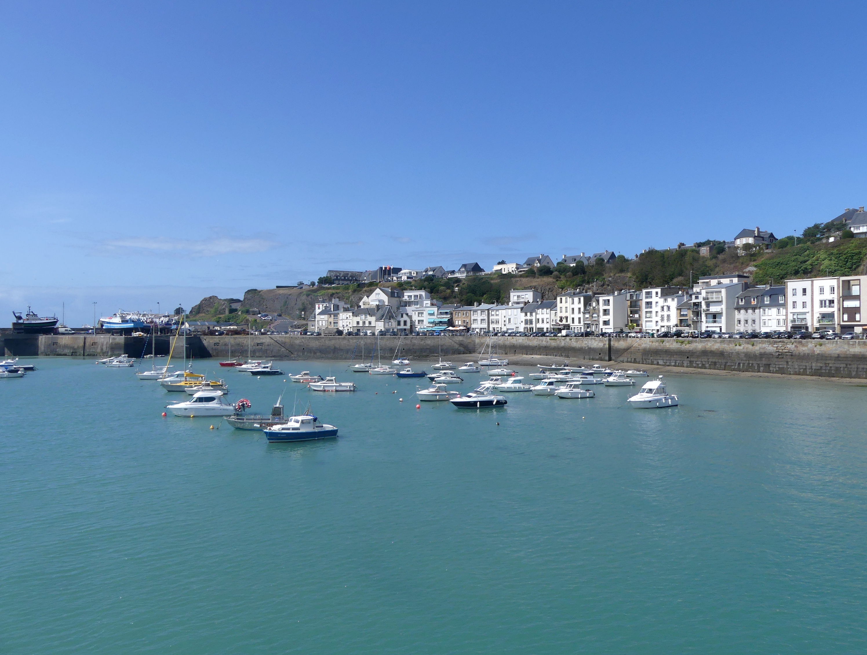
Granville’s outer harbour on 19 August 2019, described by the photographer as an outgoing tide. A strip of exposed ground is visible beside the quay; this is not a low-water survey, a departure timetable or an identification of the Chausey boarding point. Photo: Florian Pépellin, Wikimedia Commons; CC BY-SA 4.0. Unmodified by publisher.

An archive of keeping passages usable
The National Archives' finding aid for the central ports administration offers a less picturesque history of the harbour. File group 19770759/101 lists material concerning removal of silt from the wet dock, dated 1948–1958, and transformation of a temporary lock into a permanent, wider one, dated 1946–1951. Nearby descriptions include reconstruction of the Jersey quay. Archives nationales, inventory 19770759, PDF p. 24, files 100–101
These are catalogue descriptions, not the engineering papers themselves. Their date ranges cannot be treated as exact construction or reopening dates, and they do not establish how passengers experienced the works. They nevertheless identify the kinds of problems the administration recorded: maintaining depth, replacing access infrastructure and reconstructing quays.
The contrast with the watercolour is productive. A painting can make the harbour seem gathered into a stable whole; an administrative inventory breaks it into recurring tasks. Passage required maintenance. The archival record directs attention towards that work without allowing us to invent the details of a repair campaign not yet examined.
Island departures carry more than visitors
The Chausey operator's practical instructions supply a present-day counterpart. Vedettes Jolie France distinguishes passenger baggage from freight and directs bulky equipment to the cargo vessel Chausiaise. It also specifies separate freight arrangements for the island's restaurants, hotel and grocery business. These instructions belong to the operator's published service conditions, checked in October 2026, rather than to an observation of a particular sailing. Vedettes Jolie France, practical information
For the operator, the waterfront is a place of sorting as well as boarding. Goods must reach the appropriate service at the appropriate time. Its request to check freight delivery hours in advance makes the shore-side part of a crossing visible: a journey begins before a vessel leaves the quay.
This complicates the familiar image of an island boat as an escape from ordinary life. The same connection supports meals, maintenance and stays ashore. A passenger may experience the departure as leisure, while the transport system also handles supplies. The published instructions establish those functions, not the proportion of passengers who are residents, workers or holidaymakers.
The tide is not the only clock
Calling the harbour's rhythm natural would leave out an important negotiation. At the port council meeting of 20 June 2025, commerce representative Pascal Blanchet linked freight constraints to the tidal port and limited opening of the enclosed basin, then asked about night loading. The recorded discussion also raised equipment arrangements and possible noise from working at night in a town-centre port. These remarks concern freight operations, not permission to alter Chausey passenger departures. Conseil portuaire de Granville, minutes, pp. 3–4
The minutes do not establish that the requested change was approved. Their value is in exposing different demands on the same hours. More flexibility for loading could encounter the requirements of port services and the interests of nearby urban life. Water levels create constraints, but people organise work around them.
This is the everyday dimension a sea view cannot disclose. A port can be close to the heart of a town precisely because ships, roads, services and homes are neighbours. That closeness is useful, but not frictionless.
Chausey changes the other end of the crossing
The island destination is also a changing edge, not a fixed dot offshore. The Conservatoire du littoral describes the extensive intertidal ground exposed at Chausey and explicitly connects arrival times with the tide. It treats the frequently repeated count of 365 islets as a tourist legend rather than a dependable inventory. That distinction is worth retaining: an appealing numerical story is not needed to explain a landscape whose exposed area changes. Conservatoire du littoral, “Îles Chausey”
The crossing consequently joins two shorelines whose accessibility cannot be understood from a static map alone. It is not necessary to romanticise this as life without clocks. The operator's delivery instructions show the opposite: changing water makes careful timing more important. Environmental variation and organised schedules work together, sometimes awkwardly, rather than cancelling one another out.
Reading the town across the threshold
The Grand'Porte and the island boarding places offer two different answers to the problem of access. One concentrates entry into a defended town. The other connects shore and vessel within a harbour whose water and working arrangements change. Neither should be reduced to a decorative foreground for the other.
Civic heritage writing explains the upper town's visible arrangement; museum interpretation and a collected image explain how that arrangement is remembered and represented. The archival inventory points towards the labour of maintaining access. Operational documents and council minutes reveal distinctions that a panorama obscures. Together, these sources support a modest but useful conclusion: Granville's local heritage includes the organisation of passage, not just the structures passed on the way. Its maritime rhythm lies in the relationship between fixed places and conditional movement. Seeing that relationship makes an ordinary departure more intelligible without turning the town into a list of attractions.
Locate the town
For regional orientation, open a Google Maps search for Granville. This community-level search is not an exact building entrance, a verified walking route or permission to enter a workshop, museum or private property. Check the institution’s own current access information separately.
Source register and boundaries
All sources accessed 2026-10-27. The claim-adjacent links above identify the consulted pages and documents.
- Ville de Granville, “Haute Ville”: municipal account; setting and attributed gate chronology, not an examined building survey.
- Musée d'art et d'histoire, “MahG”: museum interpretation of the Logis du Roi and its changing function.
- Ministry of Culture, Mérimée PA00110421: official architectural record; chronology differs from the municipal summary.
- Musées de Granville, Signac acquisition notice, 9 January 2024: museum description; original artwork and image details not independently examined.
- Département de la Manche, PRDT Granville 2024–2029, p. 7: opened PDF text describing harbour divisions and uses.
- Archives nationales, inventory 19770759, PDF p. 24: finding aid; underlying files 100–101 were not consulted.
- Vedettes Jolie France, practical information: operator's current published arrangements; no live sailing or freight booking verified.
- Conseil portuaire, 20 June 2025, pp. 3–4: recorded discussion, not evidence that proposed changes were implemented.
- Conservatoire du littoral, “Îles Chausey”: public conservation body's description of the tidal setting.
Remaining gaps: The Grand'Porte's conflicting dates require the building study or archaeological report; no resolution is asserted. Archival engineering papers, historic passenger timetables, freight manifests and oral histories were not examined. The manuscript does not quantify residents' travel patterns or claim that all port activities share one tide window. PDF text was accessible, but visual PDF inspection remains incomplete. The linked Signac image and Mémoire normande footage were unavailable and were not used as directly inspected evidence. Two municipal heritage PDFs and an older municipal upper-town brochure were unavailable and excluded. No live travel-advice verification is claimed.