Free · France
Amiens: Floating gardens and the Hortillonnages
The work hidden at the waterline
The Hortillonnages are often introduced as Amiens's floating gardens. The phrase suggests lightness, but it should not be taken literally: these are plots of land among waterways, not cultivated rafts drifting across a lake. The Musée des Hortillonnages describes marshy ground adapted for cultivation, divided into islands known as aires. The most revealing feature is the edge between a plot and its canal. Keeping that edge usable connects growing food, moving goods and maintaining the landscape. Musée des Hortillonnages, site description
A boat journey can make the gardens appear effortless. The water opens one view after another, while much of the necessary work remains below the visitor's line of sight. To understand the place as local heritage, it helps to follow the practical relationship between soil, bank and boat. The result is not a story of untouched nature beside the city, but of a landscape continually made usable.
Land and water are parts of the same workplace
Amiens Métropole's environmental account names the tasks behind the scenery: planting and harvesting, clearing the rieux and ditches, and strengthening banks. It also distinguishes commercial growing, allotments, ornamental gardens, woodland and marsh. The contemporary site is therefore not one continuous market garden with a single purpose. Amiens Métropole, “Profiter de la Nature”
Those categories change how a garden boundary can be read. It may divide two properties, separate a crop from a navigable channel, or mark a transition between tended ground and a wetter habitat. The existence of water does not eliminate boundaries. It makes their maintenance and use especially visible.
Nor is the familiar name “Amiens” a complete administrative description. The same civic account places the Hortillonnages across Amiens, Camon, Longueau and Rivery. Rivery matters particularly for this article because the museum stands there, within the wider landscape rather than in Amiens's monumental centre. The city's heritage cannot be understood solely by remaining inside its municipal boundary.
The cadastral view is different from the garden view
The regional inventory's study of Rivery identifies an early nineteenth-century cadastral section called des Aires, dated 1810–1813 and held by the Somme departmental archives under reference 3P 1232. It also describes the canals on the eighteenth-century Cassini map and the settlement's later development along roads. The consulted source is the inventory record; the original cadastral sheet was not examined. Région Hauts-de-France, Rivery, IA80002435
Even at the level of a catalogue, this is a useful corrective to the idea of a secluded garden world outside ordinary geography. The land was surveyed, named and situated in relation to settlements and routes. A water-bound plot could be part of a wider system of property and communication.
A cadastral plan would answer different questions from a scenic photograph. It could locate divisions and parcels, but it would not by itself reveal the effort of clearing a channel or carrying a harvest. The map and the working account must be read together. Neither is a substitute for the other, and a catalogue reference is a starting point for further research rather than a completed reconstruction of ownership.
The boat belongs to the working edge
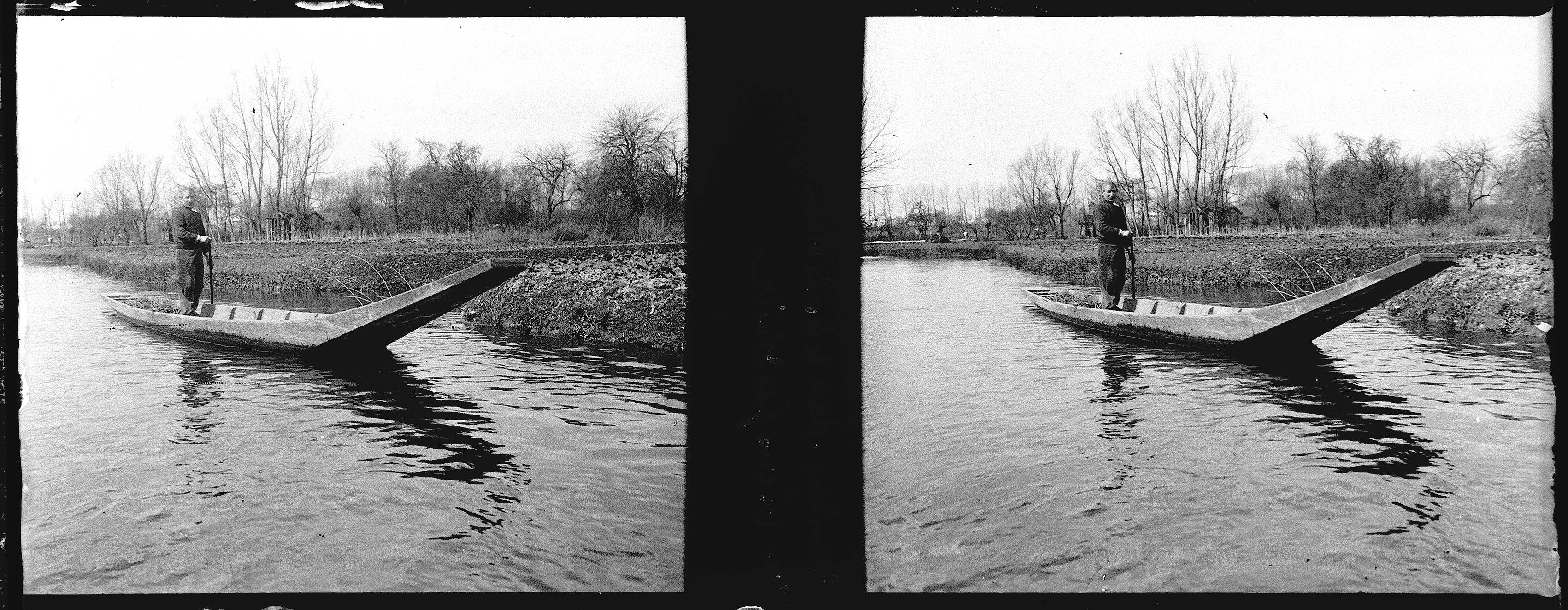
The local heritage association Hortillonnages Cultures et Traditions describes the barque à cornet as a long, asymmetrical craft used for carrying people, equipment, manure and produce. Its account identifies a boat dated 1953, nearly ten metres long, in the Rivery museum. It also challenges the often-repeated explanation that the raised end existed simply to protect fragile banks, proposing a connection with unloading at the market quay instead. Hortillonnages Cultures et Traditions, “Le domaine des hortillons”
That disagreement should not be resolved by selecting whichever explanation sounds more picturesque. No original boatbuilding plan or experimental loading study was examined here. The secure point is the craft's place in a transport system joining plots to other plots and to the market. Its form deserves investigation as working equipment, not automatic treatment as an emblem whose purpose is already obvious.
The association's description also prevents the boat from becoming merely a vehicle for removing crops. Materials had to reach the gardens as well. Thinking about movement in both directions brings the cultivated ground back into an economy of inputs, labour and distribution. The garden was not self-sufficient just because water surrounded it.
Raoul Berthelé’s 1915 stereoscopic photograph, preserved as 49Fi247 in Toulouse. Both original views are retained. It records a boat beside cultivated ground, but cannot settle the disputed reason for the raised end or identify the museum’s later 1953 boat. Photo: Raoul Berthelé / Archives municipales de Toulouse, 49Fi247, Wikimedia Commons; Public domain (PDM 1.0). Unmodified by publisher.

What a local museum can make visible
The Musée des Hortillonnages lists wooden rollers and rakes, early seed drills and motor cultivators among its tools. It also describes a traditional boat and photographs of women selling produce at the water market. This is the museum's published account of its displays, not an inspection of individual objects for wear, repairs or manufacturing marks. Musée des Hortillonnages, collection and visit description
The range is important. Wooden tools beside motorised equipment complicate the idea of an unchanging ancestral practice. A traditional landscape can contain changing technologies. Preserving its appearance does not require assuming that every generation worked it with identical implements.
The museum's own history gives the collection a local social origin. Thérèse and René Nowak, themselves market gardeners, assembled tools through personal collecting and donations; the museum association was established in 2013, followed by inauguration in 2017. Those dates distinguish the collecting initiative from the opening of the museum. Musée des Hortillonnages, institutional history
This is a strength and a boundary. Practitioners recognised equipment worth keeping, but the resulting collection is not a random sample of everything ever used. Its surviving objects show what people preserved. They cannot alone measure how common each tool was or how labour was distributed across every household.
From the plot to the market
Amiens's municipal archives connect garden labour with a specific urban destination. Their account dates the first market at Place Parmentier to 23 May 1882, following works to create the square and landing facilities. It describes produce loaded before market day, boats waiting near the Pont du Cange and women conducting sales after unloading. Amiens municipal and community archives, “Le Marché sur l'eau”
The archive feature is built around postcard 5Z898, dated to the first half of the twentieth century. Its interpretation is broader than what that single image can prove. The postcard does not establish every detail of loading practice, and the account's division of roles should not be universalised across all families and periods.
The same archival article records the later replacement of boats by vans and the transfer of the wholesale market after its final Place Parmentier edition in May 1976, while noting that some selling continued there. The change is crucial: a commemorative water-market event is not evidence that the old transport system survives unchanged. Continuity of place, produce and memory can coexist with a substantial change in how goods arrive.
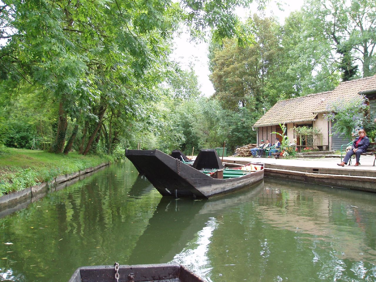
Boats and a maintained waterside landing in the Hortillonnages, photographed in September 2007. The view makes the working edge between land and water visible; it does not identify the Rivery museum boat, current navigation permissions or an unchanged commercial transport system. Photo: Amanda Slater, Wikimedia Commons; CC BY-SA 2.0. Unmodified by publisher.

Maintenance is a present occupation
A civic employment document makes the continuing work unusually explicit. Issued in December 2025, Amiens's recruitment notice for a Hortillonnages canals team leader describes separate teams concerned with dredging and with banks and floating debris. Duties include arranging channel clearance, vegetation cutting, sediment handling and communication with owners. It is a job specification, not a report that every listed task was completed or that the vacancy remains open. Amiens Métropole, recruitment reference 5416, p. 1
This document is a revealing counterpart to the museum tools. Both concern the work behind the landscape, but they record it differently. The museum gathers material traces; the recruitment notice describes responsibilities, equipment and coordination. Maintenance has an administrative life as well as a physical one.
The notice's provision for removing bulky waste from plots accessible only by boat offers a particularly clear example. Water access is not just an attractive way to arrive. It changes how an ordinary problem must be solved. A garden's apparent isolation does not free it from the need for organised services.
Not every untended corner is a failure
The conservation perspective adds an essential qualification. The Conservatoire d'espaces naturels' guide identifies ecological interest in less cultivated parts of the Hortillonnages, including ponds, marshes and silting ditches. It describes a mixture of cultivated gardens and wet habitats rather than treating all spontaneous growth as damage. Conservatoire d'espaces naturels, Amiens-area natural spaces guide, PDF p. 5
That is not an argument for abandoning every channel. It is a reason to distinguish the purpose of a particular intervention. Keeping a route navigable, protecting a productive bank and retaining habitat are not automatically identical goals. A maintenance decision can make sense for one purpose while needing qualification for another.
A March 2026 municipal article likewise reports bank repairs along the safeguarding association's visitor route and a continuing educational-garden project. It attributes these activities to the association, rather than claiming that one project represents the condition of the entire site. Amiens Métropole, “La nouvelle vitrine des hortillonnages”
The Hortillonnages become more intelligible when these scales are kept separate: one boat, one bank, a market connection, a collection and a managed network. Their heritage lies partly in the knowledge required to connect them. “Floating gardens” can remain a memorable phrase, provided it does not erase the grounded work which keeps land beside water. What seems weightless from a passing boat has depended on tools, negotiations and repeated acts of care. Looking at the waterline rather than only across it makes that dependence visible, without reducing either the gardens or their inhabitants to a picturesque survival.
Locate the town
For regional orientation, open a Google Maps search for Amiens. This community-level search is not an exact building entrance, a verified walking route or permission to enter a workshop, museum or private property. Check the institution’s own current access information separately.
Source register and boundaries
All sources accessed 2026-10-27. Consulted URLs appear beside the relevant claims.
- Musée des Hortillonnages: three opened pages covering the site, collections and museum origins. Displays are described from the institution's account, not direct object examination.
- Amiens Métropole, environmental account: opened civic explanation; mixed land uses and four-commune geography.
- Regional inventory IA80002435: opened cadastral and settlement references; original maps not inspected.
- Hortillonnages Cultures et Traditions: opened local association research; boat function dispute explicitly retained as unresolved.
- Toulouse municipal archives cooperation image 49Fi247: Commons photographer, 1915 date, holding and public-domain metadata checked; complete stereoscopic digital image inspected. Separate from Amiens postcard 5Z898.
- Amiens municipal archives, 2019 feature: opened postcard record 5Z898 and historical interpretation; neither underlying administrative files nor original postcard examined.
- Recruitment reference 5416, issued 2 December 2025: opened PDF text, used as a duty specification, not proof of staffing or completed works.
- Conservatoire d'espaces naturels guide, PDF p. 5: opened conservation account of the landscape mosaic.
- Amiens Métropole, 24 March 2026: opened civic reporting, with the association's works and plans kept attributed.
Remaining gaps: No current parcel ownership audit, crop-output series, bank-condition survey, original boatbuilding drawing or household labour study was consulted. Published area totals differ between sources; no exact site acreage or current number of market gardeners is asserted. The prefecture's navigation page, the museum's seasonal article and the inventory image were unavailable and excluded. PDF text was available, but visual PDF inspection remains incomplete. This article does not provide current navigation-rights advice.