Free · France
Chinon: The river port beyond famous historical personalities
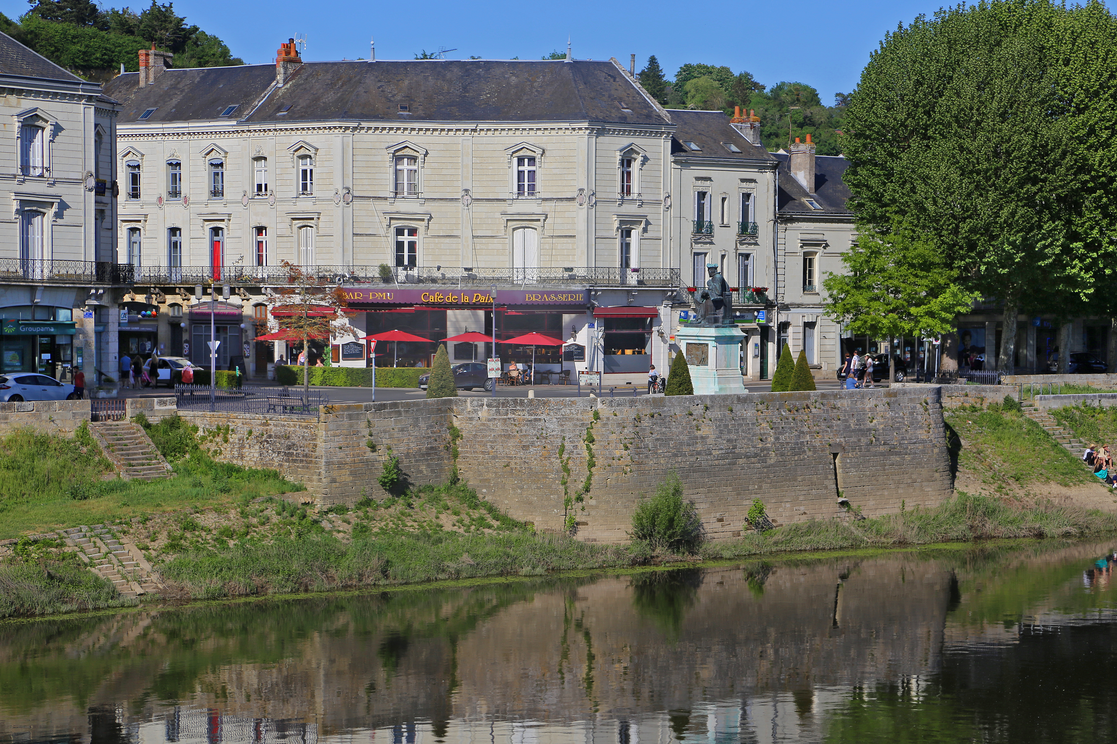
Where the river meets the street
Chinon's waterfront can be read without beginning with a royal arrival. Its revealing feature is the connection between water, crossing and urban street: the places where movement along the Vienne meets movement across it or into the town. Bruno Dufaÿ's study for the Archaeological Atlas of Touraine places Chinon's rocky spur above a river crossing and an east–west route at its foot. That arrangement helps explain why the lower town matters independently of the fortress skyline. A river port is not simply a picturesque stretch of bank; its usefulness depends on connections inland. The atlas also acknowledges the limited archaeological evidence for parts of the lower settlement. The setting supports a geographical interpretation, not a reconstruction of every medieval quay. Starting with these intersecting routes makes the ordinary work of reaching, crossing and supplying a town visible before any celebrated individual enters the account. Archaeological atlas: Chinon's settlement
Chinon's riverfront in May 2018: steps connect different levels between the water's edge, masonry wall and street. Read these visible relationships rather than imagining a complete historic cargo-handling scene. The photograph does not identify the age or former use of every step, and is not access or flood-safety advice. Photo: W. Bulach / Wikimedia Commons, CC BY-SA 4.0, original and rights record. Unaltered; businesses and passers-by are incidental.

A toll is not a traffic count
Written records reveal another part of that working landscape: rights over movement. Elisabeth Zadora-Rio's atlas study distinguishes charges on passage from charges on merchandise, while noting that historical terminology can blur the distinction. Chinon appears in this regional history of crossings and tolls. Such evidence establishes that circulation could be controlled and made a source of income. It does not, by itself, give a reliable daily total of vessels or carts. A document recording an exemption or dispute preserves a particular relationship between authorities and users, not an impartial census of everyone who passed. Even the historical word port can refer to different arrangements, including a ferry landing or a place for unloading goods. Reading the records this way prevents the modern imagination from furnishing every named port with the same warehouses, cranes and busy commercial scene. Archaeological atlas: bridges, ports and tolls
The bridge has a repair history
The national architectural inventory supplies a more concrete documentary anchor. Its bridge record identifies a wholly stone bridge in Nicolas Poinctevin's album of 1682. That is evidence reported by the inventory, not an original drawing examined for this manuscript. The record also lists widening and repair in 1853–54, wartime destruction of the northern part in 1944 and another widening in 1967. These interventions make an important distinction between the persistence of a crossing and the survival of an unchanged structure. A bridge can remain central to the town while its usable width, fabric and approaches change. Its history therefore belongs as much to maintenance and interrupted circulation as to foundation stories. The inventory's more tentative statements about early construction should not be turned into precise certainties merely because a famous ruler can be attached to them. General Inventory bridge record, IA00060335
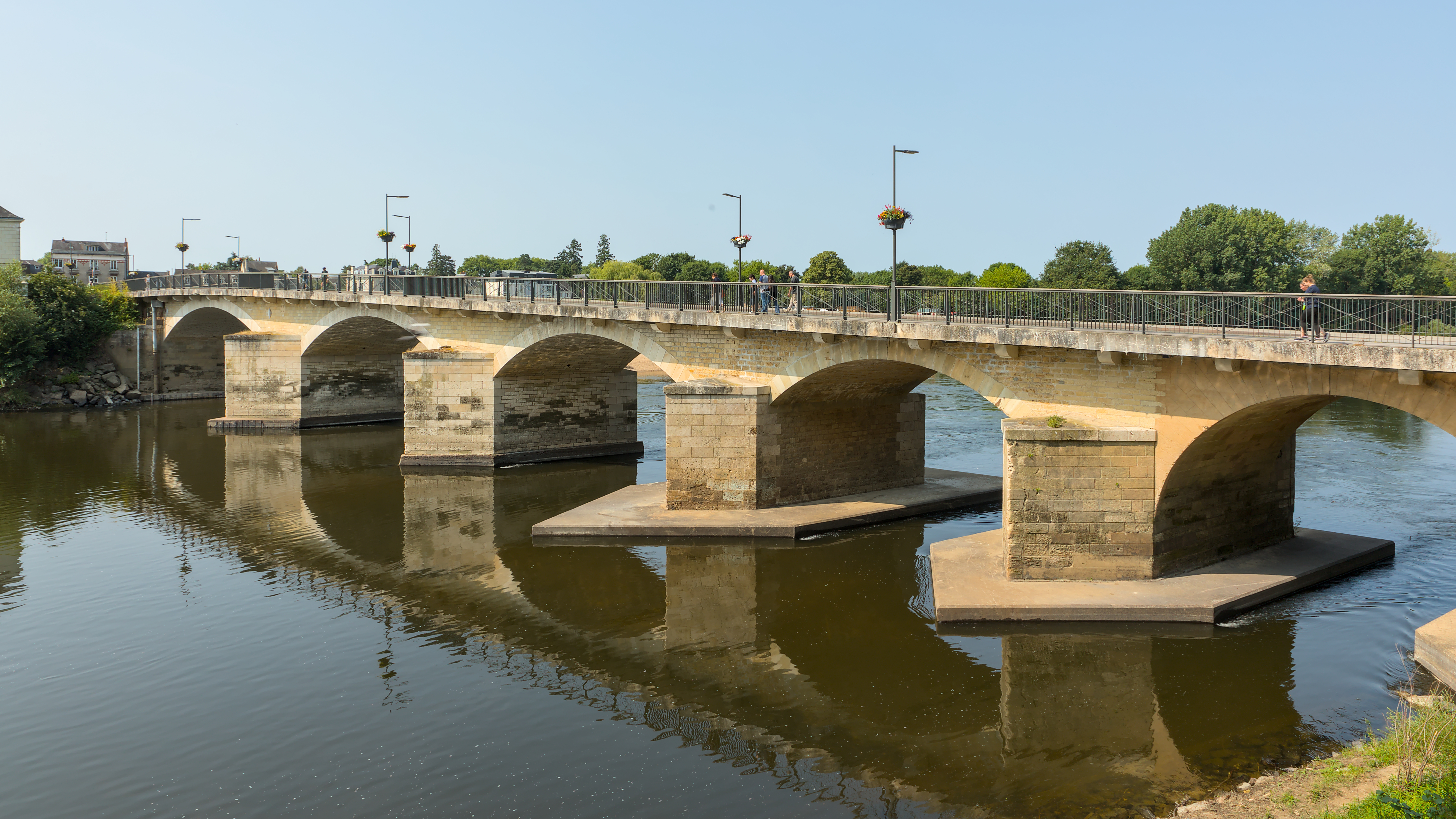
The Pont Aliénor d'Aquitaine, 9 June 2025. A present-day view makes the crossing's connection between riverbanks visible, but it cannot date each pier or repair; that chronology comes from the inventory discussed above. Photo: Benjamin Smith / Wikimedia Commons, CC BY-SA 4.0, original and rights record. Unaltered; no endorsement or identity claim about incidental pedestrians.

A defensive edge becomes an urban frontage
The municipal heritage trail describes the creation of quai Charles VII in the 1820s in place of medieval defensive walls. It presents the resulting embankment as both flood protection and a major road, with plane trees towards the river and nineteenth-century stone houses towards the town. This is a substantial alteration of the relationship between street and water, not simply a change of architectural decoration. The same guide explains that removing a chapel after the Revolution improved access from the bridge area towards rue du Commerce and the market square. Read together, these changes suggest a waterfront being reorganised around circulation and frontage. They do not prove that every improvement served boat traffic, or that the new embankment eliminated flooding. A quay may carry several urban functions at once; calling it a port should not erase its role as a road and town boundary. Municipal heritage trail, waterfront and bridge approach
The Parerie connection
East of the older centre, a different connection linked the port of the Parerie to a large space for fairs and markets. An Association Vauban study of Chinon describes that relationship and the nineteenth-century reshaping of the fairground as place Jeanne d'Arc. Its account also traces development towards the railway station established in 1873 and the later creation of a planted riverside promenade. The useful point is not a simple succession in which boats disappear the day trains arrive. It is that landing place, market space, railway and promenade belong to different ways of organising movement and public ground. The study supplies a spatial interpretation, but no port ledger from which to calculate the changing shares of river and rail freight. The former waterfront should therefore be understood as a changing set of connections, rather than as one vanished commercial institution with a single closing date. Association Vauban study, printed page 24
Similar names do not prove the same use
The name Parerie also appears in the inventory record for a tithe barn at 3–5 place Mirabeau, later the Hôtellerie du Croissant. The record assigns an uncertain twelfth-century date to the earlier building and describes conversion to an inn in the seventeenth century. This is evidence of another working building changing purpose, but it must not be silently recruited as a documented warehouse for the port. Shared place-names are clues for research, not substitutes for deeds, plans or accounts connecting particular premises to particular cargoes. The difference matters because an attractive story can otherwise form too easily: old barn, nearby river, therefore merchant store. Here the secure sequence concerns the building's recorded functions, while any detailed relationship to river freight remains to be demonstrated. Ordinary urban history becomes more precise when these tempting but unsupported connections are left open. General Inventory: Parerie tithe barn, IA00011607
The river enters the museum
Le Carroi's institutional programme for 2026 gives the river a place inside the town's museum. It lists Vivre entre Vienne et Loire upstairs, Croquer la grande remontée de Loire in the entrance hall and Curiosités chinonaises on the ground floor. These are evidence of how the museum chose to frame local history during that season. They are not an inventory of surviving equipment from the Parerie port. Without the detailed exhibition catalogue, it would be misleading to supply imagined ropes, cargo samples or boatmen's possessions. Nevertheless, the programme offers a useful contrast with the architectural sources: the museum presents living between rivers as a subject in its own right, rather than merely a backdrop to a royal episode. Its published titles place local curiosity and river experience within the same institution. That curatorial choice is meaningful even when individual objects and visitor responses remain unverified. Le Carroi's published 2026 programme
Models in a civic setting
A municipal announcement from March 2024 shows another way of representing navigation. For the Fête du timbre at the town hall, the city advertised collaboration with La Poste and the boat association Les Vents d'Galerne, including models of its fleet. The announcement connects boats with a civic room and a collecting activity, not only with the water's edge. A model can make hull shape and rigging available for close attention while the full-sized vessel remains elsewhere. Yet the document records an advertised programme, not a report confirming everything displayed or measuring attendance. Its value lies in the named participants and intended setting. The river's public memory was being organised through municipal communication and an association's contribution. This is a modest, specific form of heritage-making, different from both commercial freight handling and the claim that an entire population shares an unchanged boating tradition. Chinon municipal newsletter, March 2024
Skills can persist while purposes change
The French intangible-heritage inventory of Loire nautical knowledge helps explain the distinction. Its research includes the Loire's tributaries, notably the Vienne, and describes professional and amateur communities engaged in building, maintaining and navigating boats. It explicitly locates continuity less in the economic character of the activity than in people's relationship with the river and the knowledge that relationship requires. This regional evidence should not be mistaken for a census of Chinon's boat workers. It does, however, offer a better vocabulary for interpreting local heritage navigation. Reading water and wind, caring for a hull and handling a vessel may remain meaningful practices when the principal task is no longer carrying commercial loads. Continuity of skill and change of livelihood can coexist. Neither a romantic assertion of timelessness nor a dismissal of all present boating as mere imitation captures that distinction. French intangible-heritage inventory: Loire nautical knowledge
A landing place with a different purpose
The Compagnie de Navigation Vienne-Loire identifies quai Danton as its Chinon embarkation point and advertises outings combining river scenery, local history and food. This is direct evidence of how an operator presents its activity, not an independent endorsement of its interpretations or a guarantee of departures. What matters here is the changed transaction: passengers purchase an experience of the river rather than arrange the onward movement of cargo. The waterfront still connects land and boat, but that shared physical action does not make leisure navigation equivalent to the former freight economy. Chinon's port history is clearest when these differences remain visible. A crossing repeatedly repaired, a defensive edge remade as quay, a market-linked landing place, a museum programme and contemporary embarkation all describe work done around the same river. They bring the town back into the story without requiring a procession of famous personalities. Boat operator's account of its Chinon activities
Location orientation
Chinon, France — general map search. This town-level orientation is not a verified entrance, cave-access permission, safe river route, event booking or current departure schedule.
Source register and editorial boundaries
All sources below were opened on 27 October 2026. Paragraphs distinguish documentary evidence, institutional presentation and editorial interpretation. No historical passage is quoted at length.
- University of Tours, Archaeological Atlas, notice 158, Bruno Dufaÿ: settlement geography; limited lower-town evidence.
- University of Tours, Archaeological Atlas, notice 212, Elisabeth Zadora-Rio: documentary terminology and control of circulation. Historical research, not a current archaeological survey.
- Ministry of Culture, POP IA00060335: bridge inventory; Poinctevin reference and later interventions. Original album not inspected.
- Municipal English heritage trail, hosted by the official tourism office, waterfront section: quay and approaches. Historical description, not a contemporary flood-safety assessment.
- Association Vauban, Chinon study, 2011, printed page 24: Parerie, market space and subsequent urban changes. Institutional heritage synthesis, not an original freight register.
- Ministry of Culture, POP IA00011607: building identification and uses; uncertain early dating retained.
- Musées Chinon Vienne et Loire, Le Carroi programme, updated April 2026: exhibition titles only; no object-level inference.
- City of Chinon, March 2024 newsletter, page 1: advertised civic programme; completion and attendance not established.
- PCI-Lab national intangible-heritage inventory, fiche 547: regional ethnographic research; not local workforce statistics.
- Compagnie de Navigation Vienne-Loire, individual outings page: operator's embarkation address and offer; schedules, prices and anecdotes not adopted as advice or historical proof.
Remaining gaps: No original Chinon port accounts, cargo series, Poinctevin drawing or parcel-level Parerie plan was examined. The dedicated museum exhibition page failed to load; the museum's successfully opened programme supports only the narrower claims used here. Detailed cargo handling, named boat workers, precise landing boundaries and commercial volumes remain unresolved. This account does not equate the Parerie barn with a port warehouse or treat museum programming as a completed-outcome report.