Free · France
Saint-Jean-Pied-de-Port: Navarre fortress and pilgrimage crossroads
At 55 rue de la Citadelle, a building once connected with the fortress now accommodates pilgrims. Farther along the same street, the Porte Saint-Jacques marks a historic entrance to the town. Above them, the citadel houses a school. Few places bring the successive uses of a frontier settlement into such a compact space: defence, travel, hospitality and ordinary education remain neighbours.
Saint-Jean-Pied-de-Port is often approached as the beginning of a long walk. Its own history deserves more than a hurried evening before departure. The mountain crossing helps explain why a fortified town developed here, while the streets below the fortress reveal how people passed through, traded, stayed and adapted buildings to new purposes.
The town's name contains that geography. In the local tourism office's explanation, “port” refers to a mountain pass. Donibane Garazi, its Basque name, belongs to the same inhabited place. The destination is at the foot of a crossing, well inland from any seaport. Pays Basque tourism, 2025 town guide.
A Navarre stronghold beneath the later citadel
The Vauban network's historical account records a castle of the kings of Navarre here in 1189, during the reign of Sancho VI. It describes the later connection between the town walls and the castle. This gives the hill a history that predates the familiar name of Vauban by several centuries. Réseau des sites majeurs Vauban.
The distinction matters because a dominant structure can make a place seem to have been created in one campaign. At Saint-Jean-Pied-de-Port, the military site inherited an earlier position and a settlement below it. The visible fortress is one phase in a longer attempt to hold an important approach to the mountains.
Look at the town and hill together. The high ground offered a commanding position; the lower streets carried movement. Defensive occupation and civilian passage needed the same geographical setting for different purposes. That relationship is more revealing than assigning the whole scene to one celebrated engineer.
The medieval castle should not be imagined as an intact visitor attraction hidden inside the present buildings. The heritage sources describe replacement and remodelling. Where stone survives from different periods, identifying it precisely requires architectural evidence; a weathered appearance alone cannot date a wall.
The seventeenth-century works began before Vauban
The municipality places the early citadel's construction around 1625–27, followed by improvements during the 1640s. It associates the later work with Vauban's 1685 visit and gives 1728 as a completion milestone. The Ministry of Culture's monument record likewise identifies a seventeenth-century fortress subsequently remodelled by Vauban, noting that buildings following his plans could be executed after his own period. Municipal heritage account; Mérimée record PA00084506.
A clear chronology therefore has several stages: the Navarre castle, the early bastioned citadel, subsequent redesign, and later execution of buildings. “Vauban's citadel” can be a convenient shorthand, but it compresses the work of different generations.
The hillside setting also imposed practical constraints. A fortress had to accommodate entrances, quarters, stores and circulation within a limited elevated site. From outside, follow how its outline occupies the ridge. The exercise is to connect shape and terrain, rather than to identify every projecting wall from a military glossary.
There is no need to turn the visit into a claim that the position was impregnable. The surrounding mountains were part of the engineers' problem as well as the view. A commanding site can still be overlooked from elsewhere, and the design of a defensive position changes with the threats anticipated by its builders.
Gates organised passage through a working town
The 2025 tourism guide identifies the Porte de Navarre with the approach to the former medieval market space near the church. It places the Porte Notre-Dame by the old bridge over the Nive and the rue d'Espagne district. These links bring commerce and the river into a story often dominated by the citadel. Pays Basque tourism, 2025 town guide.
A gate narrows movement. Whatever the traveller's purpose, the built opening determines where that person, cart or load can pass. The street beyond then brings movement beside houses and places of exchange. Read the opening and its immediate surroundings as one arrangement: threshold, route and destination.
This helps explain why military and commercial histories are difficult to separate. Walls protected a town, but a town also needed entrances through which goods and people could arrive. The bridge connected inhabited areas across the river. These features served daily relationships as well as exceptional moments of conflict.
The old street is still an inhabited street. Doorways, shops and lodging entrances have present users. Looking at an inscription or a façade does not confer access to a private interior, and a photograph should not obstruct someone's work or journey.
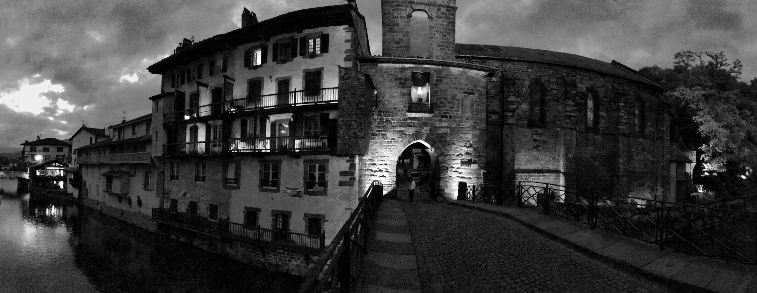
Porte Notre-Dame and its river crossing: a different threshold from the Porte Saint-Jacques discussed below. Photo: Edmir Silvestre, original Flickr publication, CC BY 2.0, published in 2015. Exact capture date is not verified: the page marks its date as unknown, while the file records a September 2015 modification. The photographer’s black-and-white full frame is unchanged. This historical view establishes neither current lighting nor public access conditions.
What the Porte Saint-Jacques actually represents
The tourism office's heritage record describes the Porte Saint-Jacques as the historical pilgrim entrance for those approaching from the Madeleine quarter of Saint-Jean-le-Vieux and continuing toward Roncesvalles. It identifies the gate as part of the UNESCO inscription concerning the Routes of Santiago de Compostela in France. Tourism-office record, published through Cirkwi.
UNESCO's property is a series of selected monuments and route sections illustrating pilgrimage. The gate's inclusion should not be expanded casually into a claim that every street, the citadel and the entire modern walking network form one identical inscribed component. UNESCO property record.
The gate is powerful precisely because it makes a wider network tangible. A traveller approaching a long-distance route encounters a small piece of architecture at the scale of a body and a doorway. The surrounding mountains give that threshold a particular meaning: passage through the town precedes passage across a much larger landscape.
Modern arrivals do not all follow the same approach. Some people reach Saint-Jean-Pied-de-Port by train or road; others have already walked for weeks. The historical entrance helps interpret a route without requiring every present-day traveller to reproduce one sequence of movements.
Hospitality has its own modern history
Terres de Navarre, the association managing Ospitalia, recounts the gradual rebuilding of pilgrim hospitality during the twentieth-century revival of the route. Its account recalls Madame Debril receiving travellers in her home before municipal space became available. The present refuge at 55 rue de la Citadelle occupies a seventeenth-century building that the association identifies as a former dependency of the citadel. Ospitalia's history and operating information.
That building makes a particularly concrete connection between the fortress and the pilgrimage town. A structure associated with the military complex now supports people preparing for a mountain journey. Its reuse is part of local history in its own right.
Hospitality requires people, rooms, maintenance and an operating arrangement. The existence of a medieval route does not automatically provide a modern bed. The association's history shows how reception was organised through individual effort, civic support and later management. It is a reminder to notice the labour behind a place described simply as a “pilgrim town.”
Practical information on the same page needs care: an older paragraph speaks of year-round reception, while the dated operating section announces a seasonal closure from 1 December 2026 through 28 February 2027. Check directly for the intended stay. No bed availability or reservation is established by this article.
The school is part of the citadel's present
The Ministry of Culture record identifies the citadel's current use as a collège. The protected structure is consequently part of an active educational setting. It should not be approached as an empty monument whose interiors are always available to visitors. Mérimée monument record.
This everyday use adds another layer to the hill. A place shaped for military occupation now has an ordinary school rhythm. That continuity of occupation differs from preserving a fortress solely as a museum. Public access must fit the actual site's rules, and visitor curiosity should never intrude on pupils or school operations.
From public viewpoints, the exterior and the town's relationship to the hill are sufficient to understand much of the setting. Any interior visit should be checked with the authorised organiser for the relevant date. A past heritage-day programme is not a standing invitation to enter.
An unhurried way to connect the places
Give the hill and the street different kinds of attention. From a lawful public viewpoint, study the citadel's position over the settlement. In the old town, follow the relationship between a gate, the sloping street and the river crossing. Near the pilgrim services, notice how an onward journey produces needs within the town: information, rest and accommodation.
These are interpretive suggestions rather than a turn-by-turn walking route. Slopes, steps, closures and personal access requirements need separate checking. The mountain stage beyond the town also requires current local advice; architectural heritage is no evidence that a high route is safe on a particular day.
For a source-identified point of orientation, the tourism-office record locates Porte Saint-Jacques, rue de la Citadelle, 64220 Saint-Jean-Pied-de-Port. Open the gate location in Google Maps. This map is a named-place search, not a tested pin or accessible route. For Ospitalia, use 55 rue de la Citadelle and the operator's current information, rather than confusing it with the association's contact address at number 39. Association contact page.
The strongest impression to retain is a town whose buildings keep acquiring uses. The Navarre stronghold established one relationship with the mountain crossing. The later citadel, the pilgrim gate, the refuge and the school reveal others. Saint-Jean-Pied-de-Port becomes easier to understand when these histories remain distinct enough to see how closely they meet.
Source register and limits
Sources checked 27 October 2026: municipal heritage text, retrieved as public HTML after a web-reader timeout; Ministry of Culture Mérimée record PA00084506; Vauban network historical synthesis; Pays Basque tourism's 2025 guide and its authored gate record; UNESCO's serial-property record; Terres de Navarre's refuge and contact pages. No original medieval charter, engineering plan or lodging register was inspected. The Vauban network's apparent “1624–1267” typographical range was not repeated; early-citadel chronology follows the municipal account. Proposed, executed and later-following-plan work are not collapsed into a single date.
The article does not equate the gate's UNESCO component with the whole town, promise citadel-interior access or offer mountain-route safety guidance. Historic refuge narrative is distinguished from the dated winter closure.