Free · France
Auvillar: Circular grain market and Garonne routes
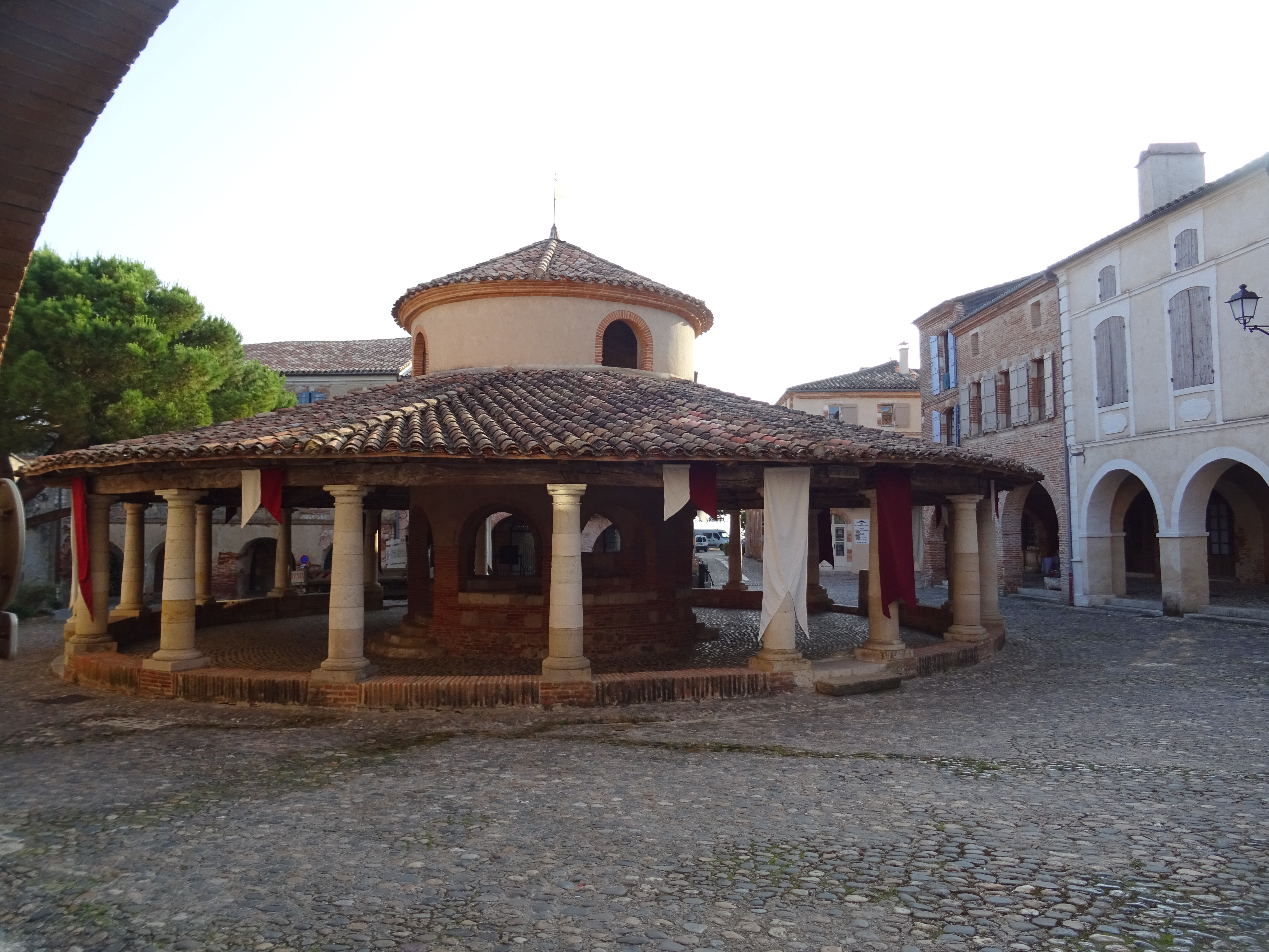
A circle inside a triangle is Auvillar's memorable piece of urban geometry. Yet the grain hall is more revealing when considered as equipment for exchange rather than an unusually shaped monument. The town's river history offers a second piece of that story: goods could be measured and negotiated in one setting, carried in another and sold somewhere else entirely.
The useful distinction is between a marketplace, where transactions become visible, and a transport network, through which products reach customers. Neither can explain the other on its own. Auvillar's upper square and lower port make that distinction unusually easy to explore, provided their different dates and functions are kept in view.
Begin with the building, not a medieval atmosphere
The regional inventory record dates the present hall to 1825–1828 and attributes it to the architect Fragneau. It describes a centred plan, stone-and-brick construction and a conical roof. This is a nineteenth-century market building, not surviving proof that the same circular structure operated in the Middle Ages. Ministry of Culture, inventory IA00039289.
There is a small but real dating discrepancy in the published sources: the municipality's introduction gives 1830, whereas the detailed inventory gives the earlier construction interval. The safest short description is “early nineteenth century”; the more precise interval should retain its attribution. A further century field in the separate protection record conflicts with both. None of these inconsistencies justifies inventing a construction history that reconciles them. Municipality: introduction to Auvillar.
Why insist on the date? Because an old settlement can acquire new commercial infrastructure. Reading every picturesque building as medieval hides investment and adaptation in later periods. The hall belongs in a history of changing facilities, not a single timeless village scene.
What the circle actually contains
The Ministry's protection description places the circular building within a triangular square edged by houses with covered ground-floor galleries. It records an outer ring of twenty Doric columns and a central structure with eight openings, a lantern and surviving stone measures. The latter stand in the raised central area. The building has been classified as a historic monument since 30 April 1946. Ministry of Culture, protection PA00095680.
These details suggest a way of looking that is more useful than counting columns for its own sake. Separate the outside circulation space from the centre and ask what each arrangement allows a person to see. Where could someone approach? What could be observed from more than one side? How does shelter relate to an open edge?
Those are observations to make, not claims that the surviving plan proves precisely where each trader stood. A building can preserve a working arrangement without preserving every rule that governed it. In particular, do not assign individual stalls or commodities to specific openings without a plan or market regulation that supports the assignment.
Look at the spaces between. The open edge and sheltered centre offer different positions from which to observe the hall. This modern view does not identify historic stalls or settle the construction-date discrepancy. Olive Titus, Halle aux grains, place de la Halle-aux-Grains, Auvillar, Tarn-et-Garonne, 10 June 2025, CC BY 2.0. Original photograph unchanged.
Stone measures point towards trust—and towards unanswered questions
A visible measure is a useful reminder that buying grain is not simply agreeing on a number. Buyer and seller also need to agree on the quantity represented by that number. This is a general interpretive point: a container used for volume raises different questions from a scale used for weight.
At Auvillar, the surviving measures make those questions concrete. They do not, by themselves, supply a complete conversion table. Avoid attaching modern litre capacities, commodity labels or an exact period of use unless a reliable description identifies them. An attractive photograph of a stone cavity is not enough to calculate its historic capacity.
The protection notice tentatively associates the central area with sworn experts and market supervision. Its wording is not a witnessed account of a particular market day. Treat that association as a reason to investigate regulation, rather than as licence to stage an imaginary scene with named officials. Protection description.
A productive question for further archival work would be: who could settle a disagreement over a measure, and what document recorded that authority? Municipal deliberations, market rules and accounts would answer a different kind of question from the architectural inventory. No such original record has been inspected for this article.
The port is a different part of town
The municipality distinguishes the port quarter below from the upper village. Its introduction identifies the Chemin du Peyrat as a connection uphill and describes the river trade in local ceramics towards Bordeaux. This establishes a relationship between levels, not a surveyed itinerary for carrying every type of merchandise. Municipal account of the upper village and port.
A useful mental map therefore has three elements: the square, the lower river frontage and the connection between them. It should not turn the entire town into one uninterrupted quayside market. Loading, storage, sale and measurement may be connected activities without occupying the same place.
Nor does the existence of a grain hall prove that every cargo leaving the port was grain. A title such as “grain market” tells us something about one building's purpose. It is not a shipping manifest. The material evidence of ceramics offers a particularly helpful counterweight to that assumption.
A plate can explain a route differently from a sack
The local museum's published account of production and trade describes Auvillar ceramics moving through the port towards Bordeaux and smaller Garonne ports. It also discusses packing fragile ware in containers cushioned with straw or hay. These are practical transport considerations, not merely decorative history. Musée du Vieil Auvillar: production and commercialisation.
The same account uses historic statistics and commercial correspondence to examine markets and changes in production. Its discussion of Maxime Castex's correspondence is a published interpretation of an archival source; it is not a register directly inspected for this article. That distinction matters if a reader wants to trace an individual shipment or verify a particular price.
Consider the difference between two questions. “Was ceramic ware traded from Auvillar?” can be answered from the museum's documented account. “Did this particular surviving plate travel on this particular boat?” needs a much tighter chain of evidence. Decoration, a maker's attribution and a general shipping route cannot substitute for that chain.
The broader lesson is that products impose different requirements on a route. Fragility brings packaging and breakage into view; bulk brings handling and quantity into view. This comparison is an analytical tool, not a claim that a surviving local account quantifies all those costs.
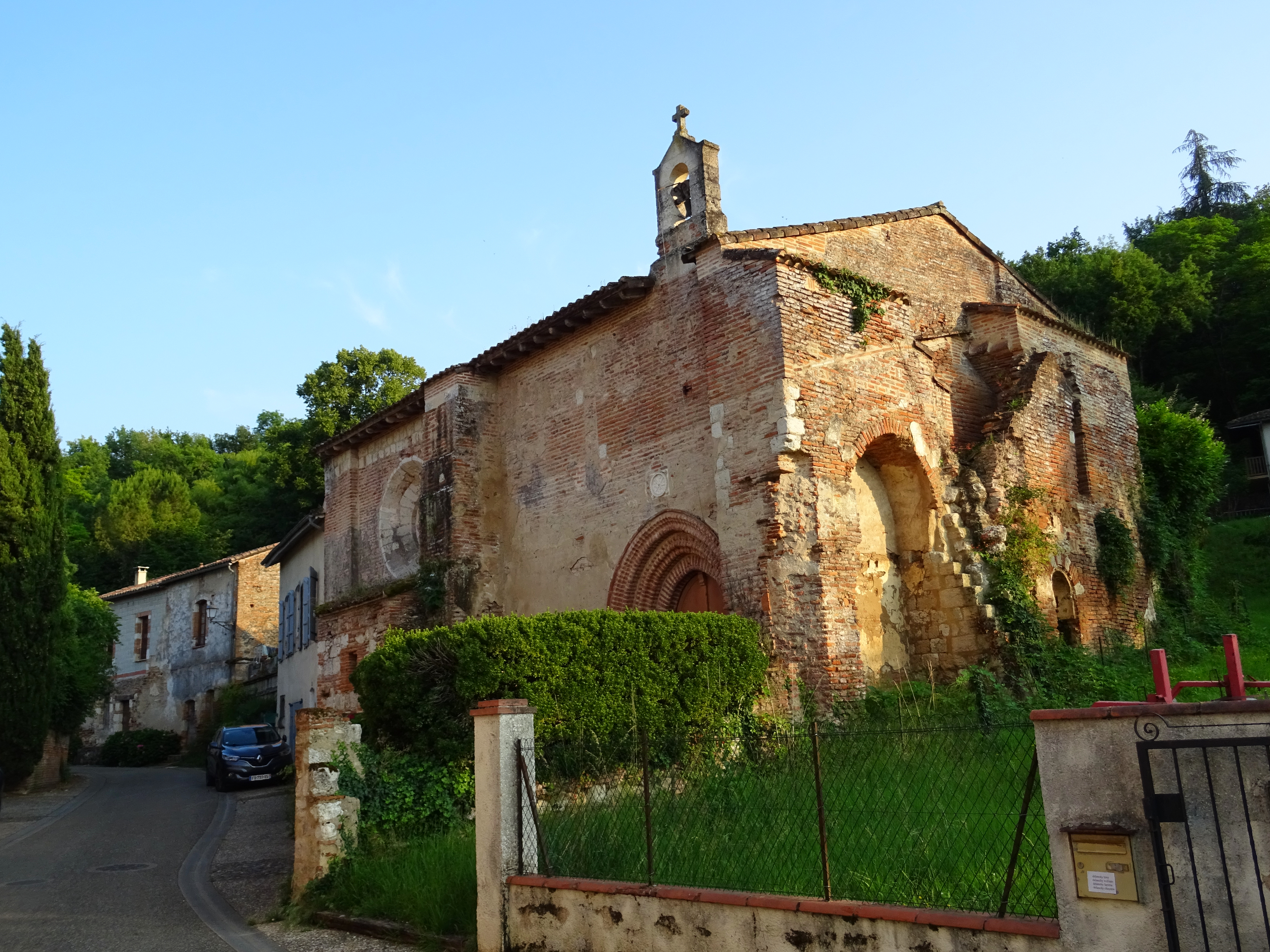
A different part of town. The photographer locates this chapel at Le Port. Its exterior provides a second spatial reference, not proof of a particular cargo, a surviving historic landing stage or access inside. Olive Titus, Chapelle Sainte-Catherine du Port, Le Port, Auvillar, Tarn-et-Garonne, 9 June 2025, CC BY 2.0. Original photograph unchanged.
Navigation, crossing and water power are not the same activity
The museum's river-history material presents models of a gabarre, a ferry and a boat mill, alongside devotional objects associated with boatmen. These make a useful set precisely because they do not all represent the same use of the Garonne. A freight vessel moves along the river, a ferry connects banks, and a floating mill uses the current for work. A museum model is an explanatory object, not an original full-size vessel. Musée du Vieil Auvillar: inland waterways.
The museum also dates the replacement of the local ferry by a suspension bridge to July 1845 and distinguishes that bridge from a later replacement in 1939. Those dates should not be folded into the hall's construction date. Market facilities and crossing infrastructure changed on separate timelines. Museum river-history account.
A view across the water can make a connection look permanent. The historical question is instead what crossing was available at a particular moment, to whom, and on what terms. The present bridge is not evidence of an identical crossing arrangement in an earlier century.
A compact comparison for reading the town
| Evidence to examine | Question it can help answer | Conclusion it cannot establish alone | |---|---|---| | Hall plan and central measures | How did the building organise a space for exchange? | Exact daily quantities or the identity of every trader | | Published construction inventory | When is this structure dated, and on what attribution? | An uninterrupted medieval use of the present building | | Museum ceramics and their labels | What objects and production traditions are documented? | A specific object's complete journey without provenance | | River-transport models | How do freight, crossing and water power differ? | That every model represents the same historical date | | Commercial correspondence discussed by researchers | Which transactions might be investigated in detail? | That an unread original record has already been verified |
Use this comparison to choose one question rather than attempting to explain the entire town at once. For example, follow measurement from the stone features to a question about market rules. Or follow fragility from a ceramic object to a question about packing and carriage. The result is a more precise account than a list of picturesque sights.
Looking today without inventing access
For orientation, use Place de la Halle, Auvillar on Google Maps. This is an address-search link, not a verified entrance pin, accessible route or guarantee that any particular part of the building is open.
The municipal museum page distinguishes summer and winter opening patterns and notes closures in December and January, with appointment arrangements. Check the current details before relying on museum access, especially outside the main season. The town's streets and the museum's interiors are not interchangeable experiences. Municipality: museum information.
Observe measures and historic fabric without using, climbing on or moving them. If a label is unreadable, leave the transcription unresolved rather than filling in a plausible word. The same restraint applies to historic routes: an orientation map does not establish a safe present-day path to the waterfront or a right to enter private property.
Auvillar's strongest lesson is not simply that commerce happened beside a river. Its hall, port and museum evidence show why commerce must be broken into operations: agreeing on quantity, protecting a product, reaching a carrier and crossing or following the water. Keeping those operations distinct makes the connections between them much more interesting.
Source register and limits
Remote research used the official building inventory and protection record, municipal descriptions and museum operator’s published historical interpretation. No field visit, interview, original commercial register or unpublished protection dossier is claimed. The inventory’s 1825–1828 date, the municipality’s 1830 date and conflicting protection metadata remain attributed rather than reconciled. No precise grain capacity, cargo total, historic transaction or current navigation service is inferred. Both dated photographs retain their original bytes and attribution; neither verifies current access or historic commercial operations.