Free · France
Le Puy-en-Velay: Volcanic pinnacles and pilgrimage routes
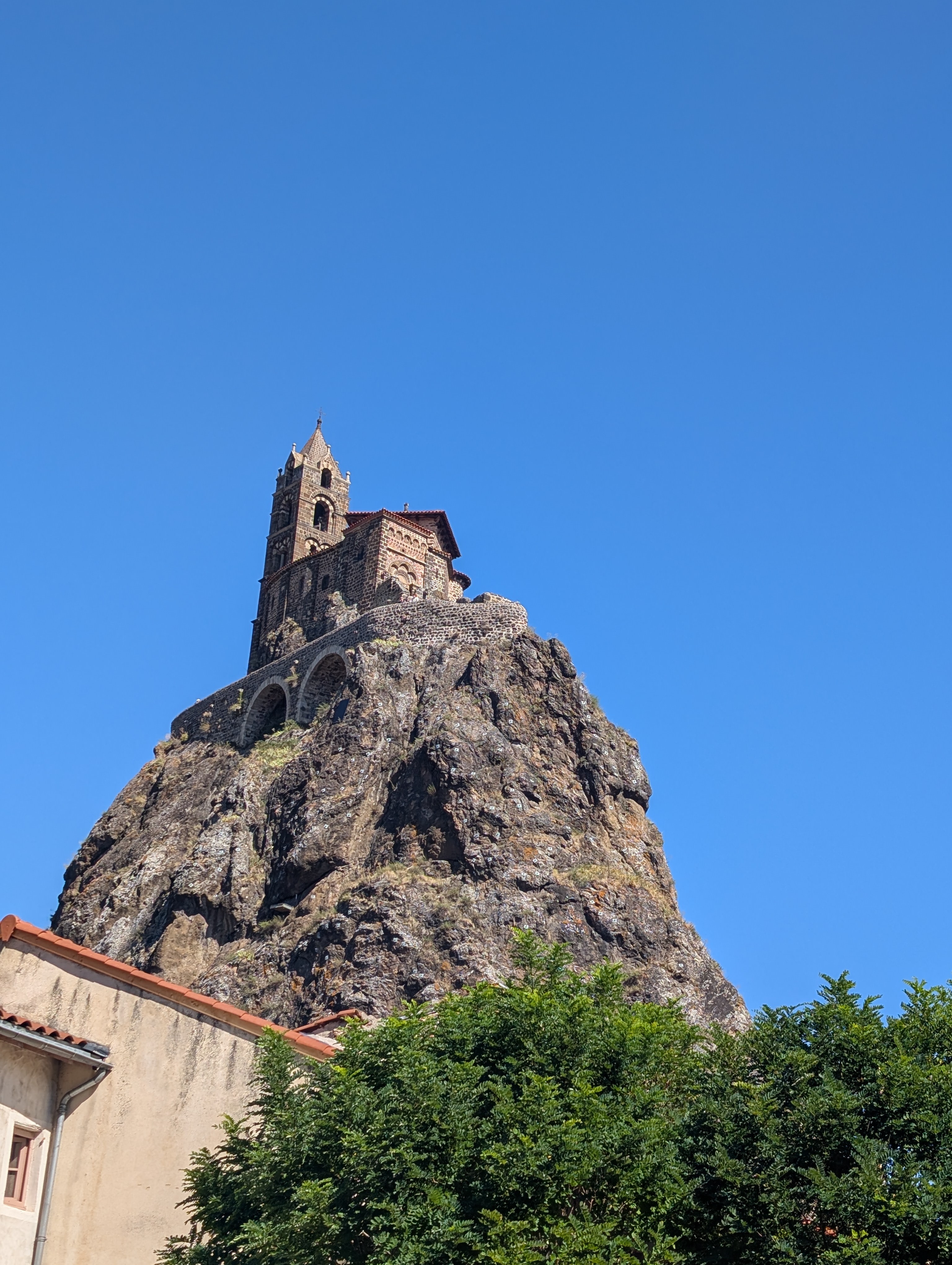
One skyline, several histories
Le Puy-en-Velay's steep silhouettes can make geology and religious history seem like a single story. They are not. A rock formed through ancient volcanic processes, a chapel built on it, and a route followed by a present-day walker belong to different times and require different kinds of evidence.
The most useful comparison is between Saint-Michel d'Aiguilhe, in the neighbouring commune of Aiguilhe, and the cathedral quarter of Le Puy-en-Velay. Both make height conspicuous. But a climb to a small summit sanctuary and a departure on a long-distance pilgrimage are not interchangeable experiences, and neither explains the origin of the rock beneath it.
The pinnacles are remnants, not intact cones
The local Pays d'art et d'histoire service describes the characteristic rocks of the Puy basin as remnants of volcanic activity under water a little over two million years ago, later exposed by erosion. It places Saint-Michel and the rocher Corneille within that explanation. This is a landscape of exposed volcanic structures, not a collection of untouched miniature cones with churches placed in their craters. Local heritage service: volcanoes
That distinction changes how to look. Ask which parts of the view belong to the rock's formation and which to later removal of surrounding material. A dramatic isolated shape can be the result of what has disappeared as well as what remains. The present skyline is not a photograph of an eruption.
A general interpretation also cannot identify every stone in a wall. Material quarried for a building may have a different source and history from the prominence supporting it. Keep the landscape explanation separate from a claim about a particular block unless a building study supplies the connection.
Aiguilhe: construction fitted to a constrained summit
The local heritage account dates Saint-Michel's development from the tenth to the late twelfth century. It identifies Truannus, dean of the cathedral chapter, as obtaining Bishop Godescalc's permission to build the first oratory, and gives its consecration in 961 with cautious wording. Later enlargement added a nave circulating around the earlier core and following the summit's shape. Pays d'art et d'histoire: Aiguilhe
This is more informative than saying the chapel was “built in 961.” A foundation date cannot date every wall, opening or decorated surface now visible. The important relationship is between a restricted site and a building that changed over time.
For a visitor, that suggests a sequence of attention: first the shape of the available ground, then the arrangement of rooms and circulation, then the decoration. Do not assume that an unusual plan is a mistake or that the entire structure followed one original design. On a small summit, adaptation itself is part of the architecture.
The operator states that the ascent uses 268 steps. That is a meaningful access fact, not a challenge every visitor should feel obliged to complete. A good understanding of the site does not require treating the climb as a test of devotion or determination. Rocher Saint-Michel official site
Rock and building, different histories. This 8 August 2026 view makes the distinction between the exposed rock and the constructed summit visible. It does not date every wall or reconstruct the ancient eruption. Андрей Романенко, Chapelle Saint-Michel d'Aiguilhe, CC BY-SA 4.0. Original photograph unchanged; access conditions require current operator information.

Interpretation can separate what the skyline merges
At the base, the operator describes a digital interpretation space with models of volcanic formation, a model tracing architectural change and a virtual view of the chapel. It presents this as an option including people with reduced mobility; contact the site about the precise arrangements relevant to your needs rather than assuming summit access. Official interpretation space
A model is valuable because it can show stages that cannot be seen together on site. It remains an interpretation, however, not the ancient landscape itself. Ask what period a reconstruction represents and which elements are known, inferred or simplified for explanation.
The same applies to dramatic lighting, narration or a spiritual presentation. These can communicate a place's meaning without becoming evidence of a geological mechanism or an undocumented historical event. Enjoy the experience while keeping the kinds of claim distinct.
The cathedral quarter is more than a summit landmark
The local heritage service describes the cathedral quarter as a historically distinct part of the city, with the cathedral, cloister, baptistery, clerical buildings and Hôtel-Dieu. It also records the chapter's development of its own authority and conflicts with the bishop, whose power extended over the lower town. The visible concentration of religious buildings therefore reflects institutions and jurisdiction as well as worship. Local heritage service: cathedral quarter
Reading the quarter this way avoids reducing it to a backdrop for departures. Different spaces served different people and purposes. A cloister, an approach stair and a church interior should not be assumed to have shared identical access or use simply because they form one architectural ensemble.
The practical lesson is to distinguish a place of worship from separately managed heritage spaces. Check the current arrangements for the part you want to visit, and do not infer that a ticket, an open door or a tour of one area gives access to all the others.
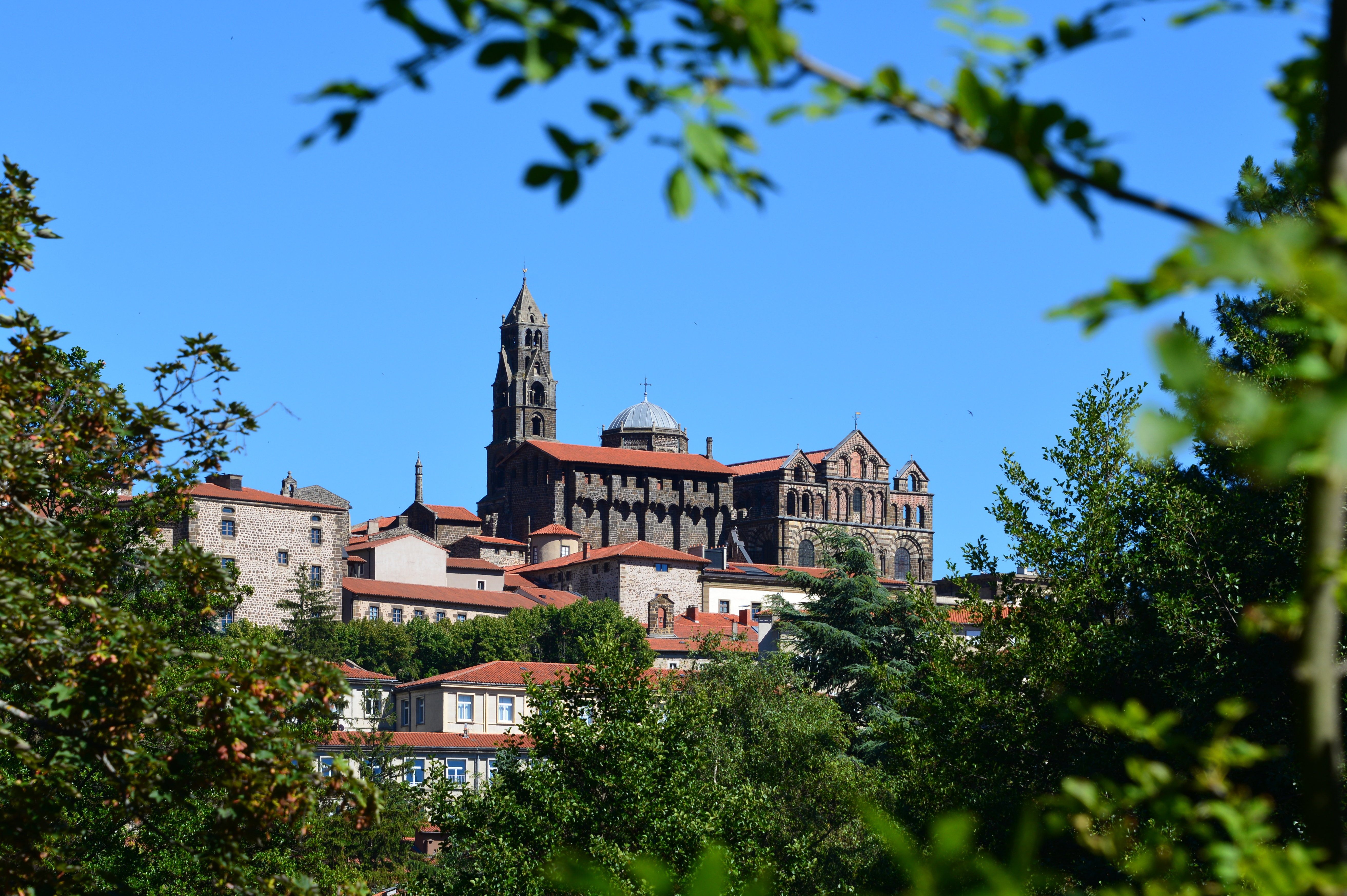
A quarter, not an isolated pinnacle. Clément Bardot's photograph of 17 July 2016 places the cathedral among surrounding buildings. Compare this urban ensemble with Aiguilhe's constrained summit; neither photograph establishes the age of every visible feature. Cathédrale Notre-Dame-de-l'Annonciation, Le Puy en Velay, CC BY-SA 4.0. Original photograph unchanged; not evidence of today's restoration works or entry arrangements.

Old-looking does not always mean medieval
A Ministry of Culture restoration account published in April 2024 describes extensive nineteenth-century rebuilding of the cathedral and its “clocher angélique”. It also describes the volcanic building stone and a temporary quarry reopened at Polignac to obtain suitable material for restoration. This is a dated account of conservation work, not confirmation of today's scaffolding or opening conditions. Ministry of Culture: the cathedral dome
Here geology re-enters the story in another form: not only the ground supporting a monument, but the material needed to maintain it. A replacement stone can preserve a building's character while being newly quarried. Recognising that does not diminish the monument; it makes the work of conservation visible.
It also prevents a misleading caption. “Medieval cathedral” can describe a building's origin and significance while concealing extensive later intervention. For a specific feature, use a specific date where the record supports one, and leave uncertainty where it does not.
A pilgrimage destination and a route departure
The heritage service's Via Podiensis timeline places Godescalc's journey to Santiago in 950–951. This establishes an important historical association. It does not prove that every stretch of today's marked route follows his precise footsteps. Local heritage service: Via Podiensis historical sheet
Le Puy's cathedral is also a place of Marian pilgrimage in its own right. The Ministry of Culture describes both its devotional attraction and its role as a departure point toward Compostela. Ministry of Culture: cathedral ensemble
Those roles can overlap without being identical. Some visitors come to pray locally; others begin a long walk; others study architecture or geology. A backpack does not disclose a person's beliefs, and attendance at a monument does not tell you the purpose of a journey. Treat living pilgrimage as a practice of people, not a costume worn by everybody in the same street.
If planning to walk, use current route information for waymarking, diversions and accommodation. This article provides historical context, not a tested itinerary, a booking promise or a current worship timetable. An old route sheet is not a substitute for today's conditions.
What the World Heritage designation covers
UNESCO's Routes of Santiago de Compostela in France is a serial property inscribed in 1998. The cathedral belongs to that wider heritage story; the designation should not be expanded casually into “every volcanic pinnacle and every path here is UNESCO-listed.” The Ministry's cathedral account and UNESCO's property record provide the appropriate starting points for checking scope. UNESCO property record · Ministry cathedral conservation record
A designation recognises defined heritage. It does not turn a whole panorama into a single protected component or certify the historical age of every modern walking sign. Precision is especially important when a local tourism phrase is broader than the formal inscription.
A three-layer reading exercise
| Layer | Ask | Useful evidence | Avoid | |---|---|---|---| | Geological | How did the rock form and become exposed? | Local geological interpretation and identified scientific study | Calling every pinnacle an intact volcano cone | | Architectural | Which phase does this feature belong to? | Building history, restoration record, dated plan | Giving the whole building its foundation date | | Living practice | What is this space used for now? | Current operator or worship information; respectful observation | Inferring beliefs or a journey's purpose from appearance |
Choose one feature and write one sentence for each layer. If you have no evidence for a layer, leave it open. This is more useful than trying to produce one sweeping explanation for an entire skyline.
For orientation, the Saint-Michel operator gives rue du Rocher, 43000 Aiguilhe. This address search for the site is not an accessibility route or a live assessment of climbing conditions. Check current opening, last-entry and access information directly. Keep to visitor paths and do not remove rock fragments or approach closed maintenance areas.
The most rewarding view of Le Puy is one that allows different times to remain visible at once: ancient geological change, successive building campaigns and people making journeys now. The skyline connects those histories. Careful looking prevents it from collapsing them into one legend.
Source register and limits
Local geological and architectural interpretation, operator access information, the Via Podiensis sheet, Ministry conservation accounts and UNESCO property documentation were consulted remotely. Some cathedral descriptions were available as official indexed text. No original charter, manuscript, geological specimen or field inspection is claimed. An exact nineteenth-century reconstruction attribution was omitted because Ministry and National Archives chronology conflict; no replacement year is invented. The two dated CC BY-SA photographs preserve their original bytes and attribution. Neither establishes every building phase, worship intention, present restoration condition or access entitlement. World Heritage scope remains specific rather than extended to the whole skyline.