Free · France
Sarlat-la-Canéda: Preservation of a medieval trading town
A historic town can survive without remaining unchanged. In Sarlat-la-Canéda, the revealing question is not whether every doorway looks medieval. It is how inherited streets and buildings have been repaired, adapted and kept useful—and which traces of those decisions can still be investigated.
This distinction makes a walk through the centre more interesting. A church converted to commercial use, a restored frontage and a shop receiving deliveries belong to the same urban story. Preservation does not simply keep change outside an ancient boundary. It determines how change happens inside it.
A town with more than one centre
The municipality's historical account distinguishes the settlement around the abbey from a second centre associated with Sainte-Marie in the twelfth century. The latter brought economic, civic and religious activity together. It also describes the emergence of municipal government and the privileges of the consuls in 1223. Sarlat's medieval history was therefore not just the history of an ecclesiastical monument: it involved competing and overlapping forms of urban authority. Municipal historical introduction.
That provides a useful starting question for the modern reader. When a square brings a civic building, an old religious structure and commercial premises into close proximity, what different kinds of activity have shared that space? The answer requires dates and documents, not an assumption that everything visible belongs to one medieval moment.
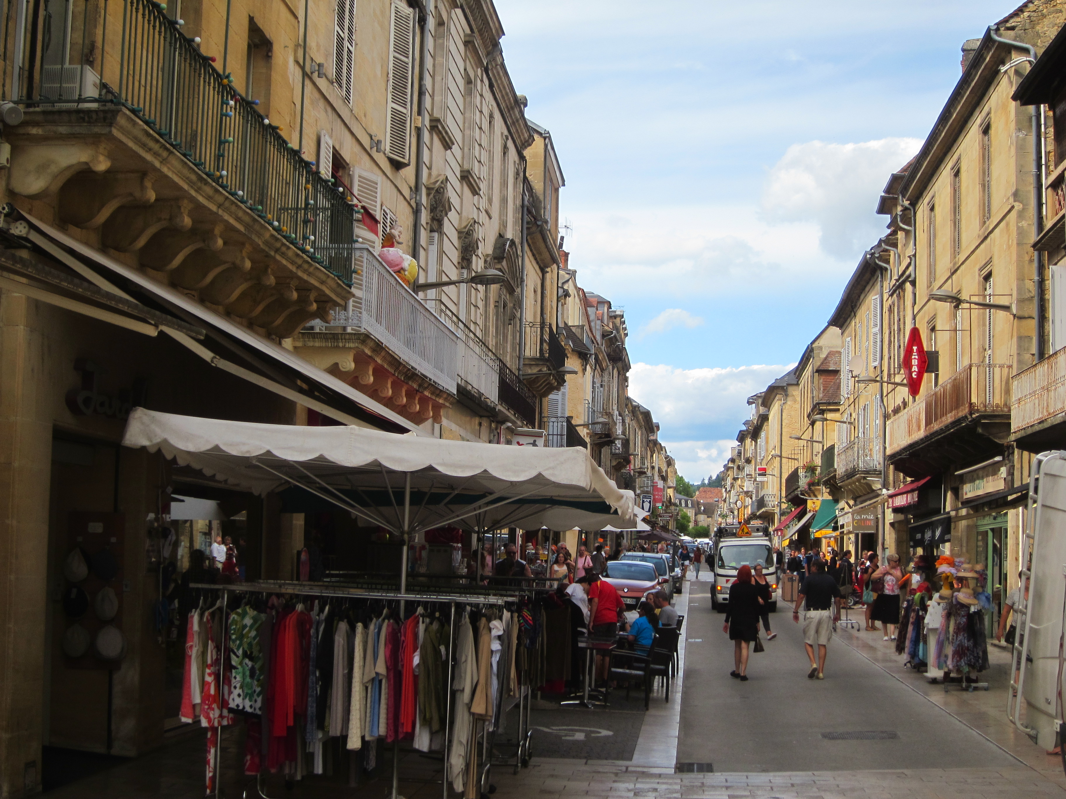
A Sarlat shopping street on 2 September 2015. Shop displays, pedestrians and vehicles document commercial use at that moment; the view alone cannot date the buildings or reconstruct their restoration histories. Photo: Henk Monster, Wikimedia Commons; CC BY 3.0. Unmodified.

Restoration also meant making buildings usable
Sarlat's municipal booklet marking fifty years of the Malraux law presents conservation as a combined architectural and urban project. It connects protection of historic fabric with improved living and working conditions, and describes the modernisation of housing, shops and public space. The town became one of the early protected sectors in 1964. The booklet treats restoration as continuing work rather than a single completed rescue. Municipal anniversary booklet, introduction.
This is important when judging a restored street. A pleasing elevation does not tell us whether rooms behind it were comfortable, whether services were renewed or how premises were used before the works. Equally, a later intervention is not automatically evidence that preservation failed. A more useful test is whether a particular change can be identified and explained.
Read the town's account as the account of an institution involved in its conservation. It establishes the aims and chronology of the programme; it does not substitute for the experience of every resident or business affected by it. Questions about who benefited, who moved and what became affordable would need additional evidence.
Sainte-Marie: a building with successive lives
The city's monument history makes Sainte-Marie a particularly clear counterexample to the idea of an untouched town. It records alterations and several later uses, including a post office, bakery and dispensary. In 2001, Jean Nouvel's intervention turned it into a covered market, with conspicuous steel doors. The building's continued presence is not the same thing as continuous religious use or wholly unchanged fabric. Municipal monument history.
The Ministry of Culture's heritage record supplies another kind of evidence. It identifies the former church's protected status, including classification in 1905, and describes its conversion to a market. This administrative record is useful for identifying the monument and its protection history. It is not a current market timetable or proof that every part of the building can be entered. POP heritage record PA00082930.
Looking at the exterior, separate three questions: what survives from earlier construction, what was added later, and what purpose the building serves now. You may not be able to answer the first two by sight alone. Recording an uncertainty is better than assigning an impressive date to a feature because its stone looks old.
The museum evidence is not limited to an open exhibition
The national museum directory describes the collections of the musée de Sarlat et du Périgord noir, including architectural sculpture from the Enfeux and hôtel Plamon, objects found during works in the old town, historical photographs and local newspapers. These offer different ways of examining urban change: fragments of buildings, material discovered during alteration and records of how the town was represented or discussed.
The same directory, updated in February 2026, lists the museum as not open. Its collection record is therefore a research lead, not a promise of a walk-in museum visit. Enquiries about particular objects or consultation should go through the responsible heritage service. Ministry of Culture museum record M0060.
An architectural fragment and a postcard do not answer the same question. The first may establish something about workmanship or a former building; the second fixes a particular view at a particular time. Neither should be asked to supply a complete history of the street on its own.
Put the recent past back into the picture
The municipality's Sarlat se souvient! De 1875 à 1975 publication deliberately extends attention beyond medieval architecture. Its introduction connects the project with collected memories and a 2019 exhibition. The period covered includes streets, shops and working lives much closer to the present than the town's most familiar historical image. Municipal memory publication.
Use such material to look for changes in function as well as changes in masonry. What occupies a ground floor? Does an opening serve a shop or a dwelling? Which part of a street is used for stopping, selling or movement? A photograph can support a limited observation about its own moment; it cannot establish that the arrangement continued unchanged for decades. Recollections are valuable evidence of experience, but a remembered date may need checking against a contemporary record.
The city was still interpreting restoration itself in 2026: a May press release announced a heritage walk using images of the maison Escande and different stages of work. This is evidence of the proposed interpretive approach, not confirmation that the event took place or an invitation to a future session. Municipal announcement, 7 May 2026.
Follow one parcel, not the whole town at once
For a more substantial investigation, select one address and one question. The Dordogne archives' cadastral guide explains how plans, section records and property matrices relate. These are fiscal and property-history sources, with their own omissions and changes in numbering; they should not be treated as complete architectural biographies. Note the record reference and date before comparing anything. Departmental cadastral research guide.
The department's digitised collections portal also provides routes into cadastral plans, population censuses, images and printed material. Its catalogue is a starting point: this article does not claim to have traced an individual Sarlat property through those records. Dordogne digitised collections.
A manageable enquiry has four parts:
- Identify the place. Record the present address and the particular frontage or space being studied. Do not assume an old street number matches today's.
- Identify the evidence. Keep the date, reference, creator and viewpoint of each document. A postcard's publication date and the date of its photograph may differ.
- Describe only what can be established. Distinguish an observed shop sign from an inference about the whole building's occupation. Ownership and residence are different questions.
- Explain the gap. If an alteration falls between two dated images, state that interval rather than inventing an exact year.
This modest method produces a more defensible history than collecting picturesque details and attaching them to a general claim about medieval continuity.
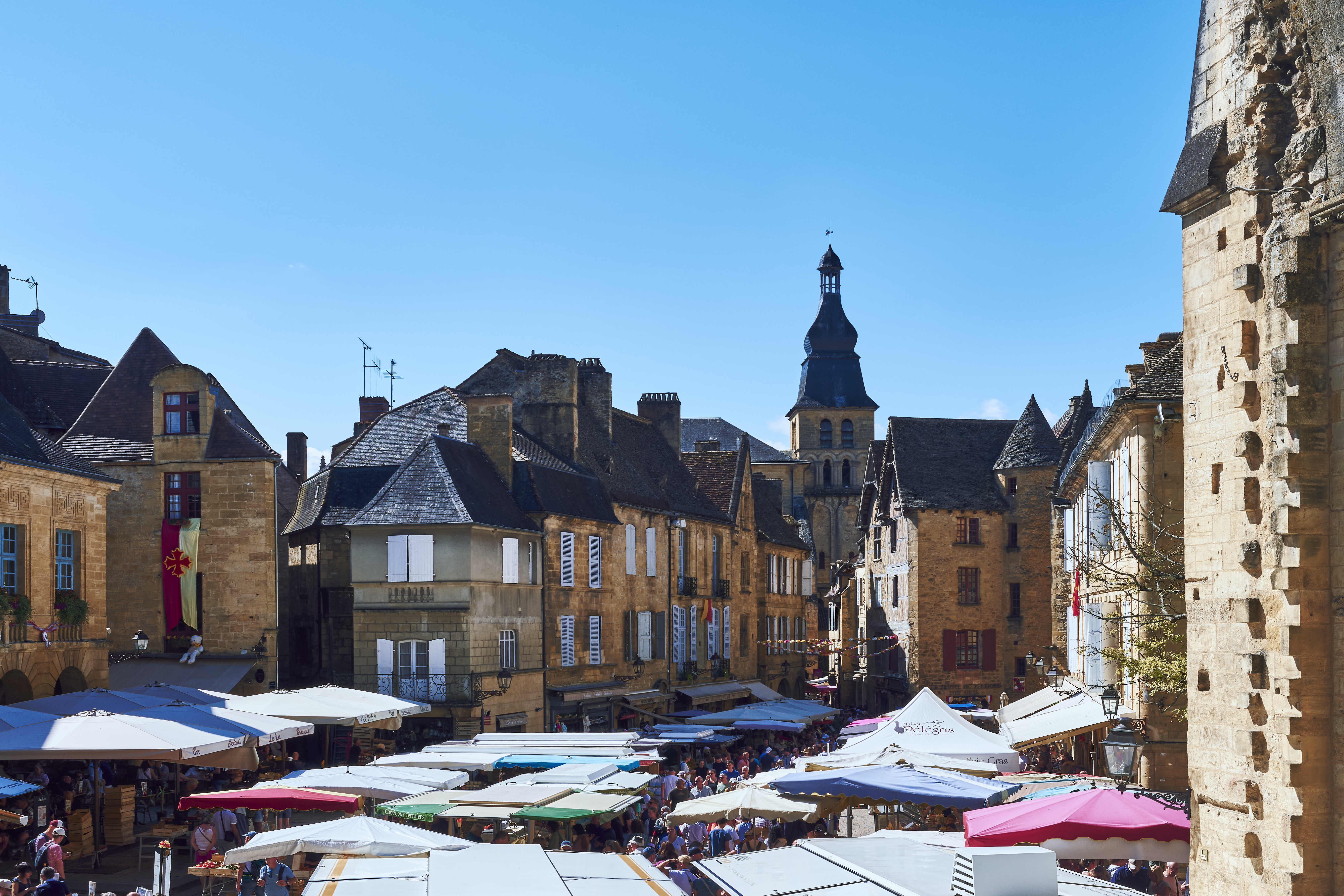
A wide view of Sarlat’s Saturday market on 2 August 2025. Trading occupies inherited urban space; the photograph is not evidence that every visible feature is medieval or that restoration was complete. Photo: Øyvind Holmstad, Wikimedia Commons; CC BY-SA 4.0. Unmodified.

A preserved town still needs ordinary services
Sarlat's current commerce page pairs the town's commercial identity with practical matters: improvements to shopping streets, cardboard collection for centre businesses and information about occupation of public space. These are not distractions from heritage. They are evidence that commercial streets have ongoing operational needs. Municipal commerce and markets information.
For a visitor, the implication is straightforward: a doorway is not automatically an exhibit, a delivery is not an intrusion to be photographed around, and an attractive courtyard is not necessarily public. Observe from publicly accessible space and leave room for people using the town for reasons other than sightseeing.
Location reference: the municipality identifies its town hall at Place de la Liberté, Sarlat-la-Canéda. Open an address search in Google Maps. This is an address-search link, not a surveyed route, an accessibility assessment or a visually verified embedded map.
Sarlat's value is not reduced by recognising restoration and reuse. On the contrary, those processes explain why historic fabric remains part of a functioning town. The most productive question to carry away is not “How much has escaped change?” but “Which changes allowed this place to endure, and what evidence lets us tell?”
Source register and limits
Sources above were checked remotely on 27 October 2026. Civic accounts, national heritage/museum records and departmental archival guidance are distinguished in the text. No on-site survey or individual property-file consultation is claimed.