Free · France
Najac: Hilltop fortress and Aveyron valley settlement
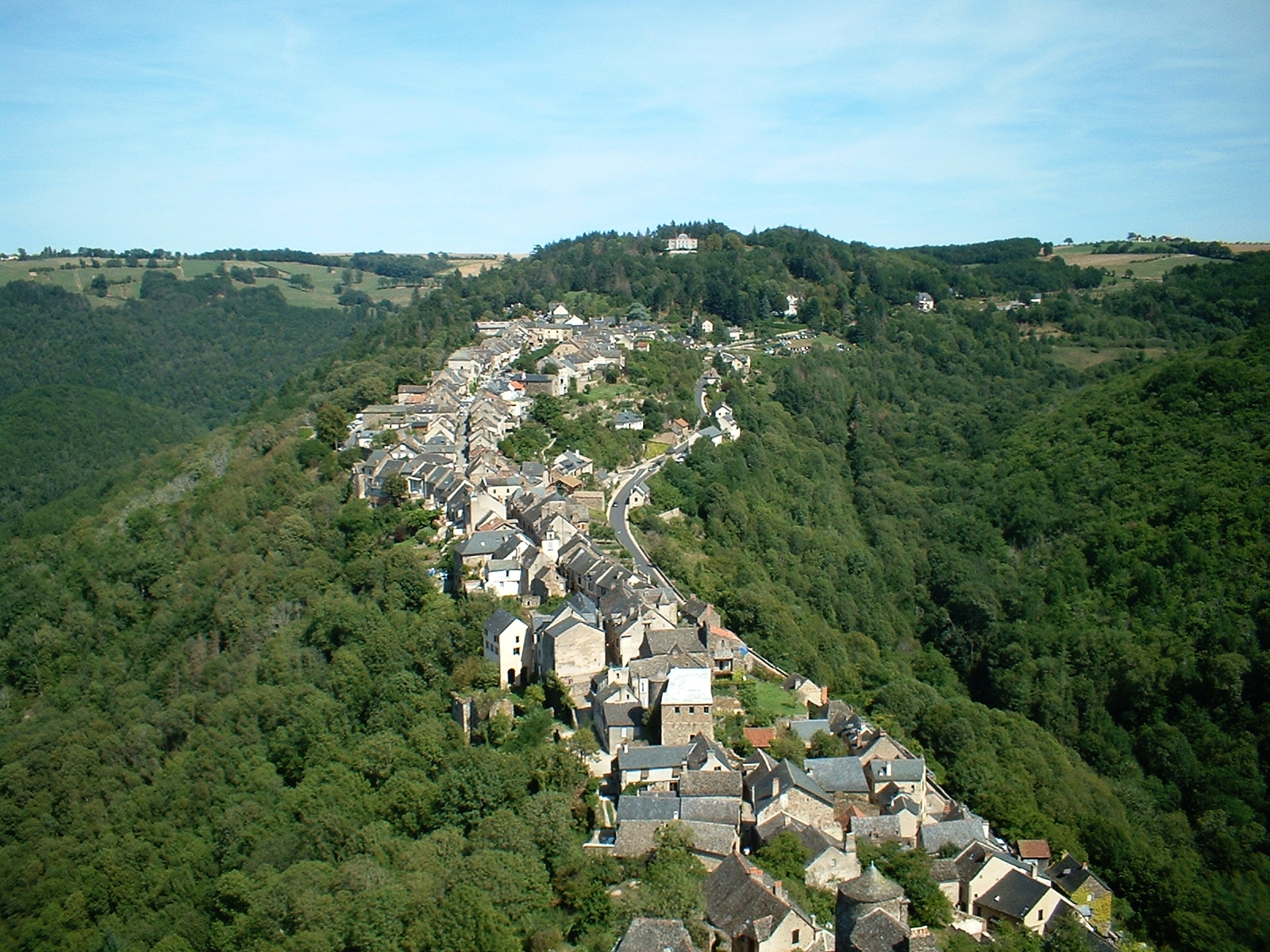
Najac's fortress is an excellent landmark and an incomplete explanation. It draws the eye to a high point, but the settlement's history also belongs to the ridge leading towards it, the houses below it and the routes reaching the Aveyron. Reading only the skyline produces a castle portrait. Reading the relationship between those levels begins to produce a history of a town.
A useful question is not simply why a fortress stands high. It is how a commanding site became connected to places where people lived, exchanged goods and crossed the river. The distinction keeps military architecture from swallowing the rest of the settlement. It also makes a visit more rewarding for someone who cannot climb every tower or descend to the valley.
A strong position, but not a single construction date
The Ministry of Culture's protection record distinguishes the surviving twelfth-century square tower from the predominantly thirteenth-century fortress. It links the stronghold to control of the Aveyron defiles and communications. The record also documents the site's later deterioration rather than presenting today's remains as a complete medieval building. Ministry of Culture: castle and second enclosure, PA00094081.
That is enough to change the first observation. Instead of asking which year “the castle” was built, ask which part a date describes. A tower, an enclosure and a later intervention can belong to different campaigns. Stonework that appears visually continuous from a distant viewpoint may not have been erected all at once.
The regional inventory adds a distinction between comital and royal power. Its indexed settlement account describes Alphonse de Poitiers strengthening his authority after the death of Raymond VII in 1249, and identifies 1271 as the point when Najac became a royal castellany following annexation of the county of Toulouse to the royal domain. This is preferable to compressing every stage into a single royal founding event. Occitanie regional inventory: Najac's castle town, IA12000217.
For a reader, the practical lesson is simple: a memorable label such as “royal fortress” can summarize an important identity without supplying the full chronology. When two short descriptions give different-looking dates, compare the event each is dating before deciding that the buildings themselves are contradictory.
Look across the slope, not only along the main street
The same indexed regional inventory account describes an initial settlement on the southern slope of the castle hill, with buildings on terraces below the stronghold, followed by extensions along the narrow ridge to the east. It also connects the La Pause suburb with the slope towards the river and Pont Saint-Blaise. Its account draws on historical documents, including medieval references to the settlement and its suburbs; those original documents were not independently examined for this article. Regional inventory: settlement form and documentary history.
A ridge is both a constraint and a connection. It can channel movement into a limited line while leaving neighbouring spaces at very different levels. This is an interpretation of the documented topography, not a claim that terrain alone determined every historical decision. Property, authority, trade and rebuilding also matter.
Read the settlement, not just the landmark. Follow the line of roofs and compare it with the wooded slopes. This dated photograph makes the ridge constraint visible; it does not prove when each house was built or certify a current route. Roger Davies, Rooftops Najac, France, 16 September 2002, CC BY 2.0. Original image unchanged.
Try separating a rough sketch into three layers:
- High ground: the stronghold and the line of the ridge.
- Built slope: houses and streets occupying different levels.
- Valley connection: the descent and the river crossing.
Then draw only the connections you can verify on a current plan. A building visible across a slope is not necessarily reachable by the direct line your eye suggests. A historic route identified in a study is not automatically an open walking path today.
This approach also gives the houses their own significance. They are not merely scale markers beneath an impressive tower. The settlement pattern raises questions about entrances, storage, street access and the effort of moving materials between levels. Those questions remain meaningful even if an individual building's medieval use is unknown.
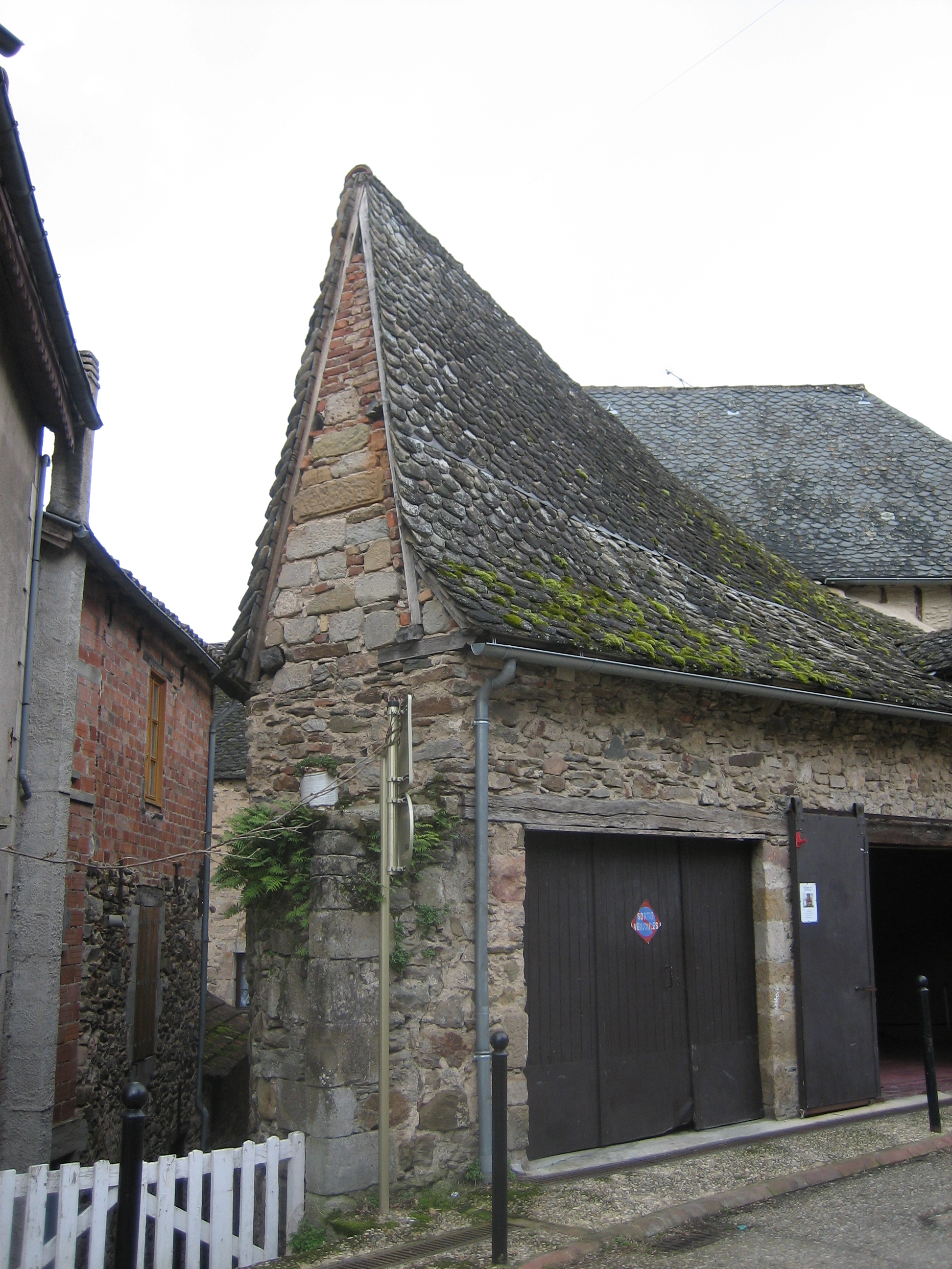
Move from the ridge to a building. Compare the roof shape, wall openings and neighbouring passage with the broader view. These visible features can generate questions about access and rebuilding; this photograph does not date the fabric or identify an original medieval use. Stephen Colebourne, Roof, Najac, 29 March 2007, CC BY-ND 2.0. Original photograph unchanged and shown in full.
The bridge gives the valley its own chronology
Pont Saint-Blaise is not just an attractive foreground for the fortress. The Ministry of Culture dates its construction to the period 1259–1274 and records restoration in 1404. Its description distinguishes the two principal arches from smaller lateral arches that were subsequently blocked. The protection record identifies municipal ownership and records classification as a historic monument in 1987. Ministry of Culture: Pont Saint-Blaise, PA00094085.
These details encourage a second kind of looking. A bridge is an engineered crossing with changes to its openings and fabric, not simply a timeless link between two banks. Its construction and repair history should be read alongside the fortress rather than assumed to match it exactly.
Do not go further than the evidence. The existence of a crossing does not, by itself, reveal daily traffic volumes, toll receipts or the goods carried across it in a particular century. Those would require additional records. Similarly, proximity to the river is not proof that every nearby economic activity used river transport.
If you cannot visit the bridge, keep it on the diagram as a documented connection rather than pretending to have inspected it. A useful heritage account can distinguish a place studied from a place physically reached. That is better than turning a steep descent into an obligatory part of everyone's visit.
A local interpretation centre widens the frame
The Maison du Gouverneur offers a way to test the skyline impression against a broader account. Its own permanent-exhibition page describes four rooms addressing landscape, history, urbanism and architecture, within a medieval merchant house now used as a Centre d'Interprétation de l'Architecture et du Patrimoine. It uses models and other interpretive media to explain the surrounding territory. Maison du Gouverneur: permanent exhibition.
That makes it more than a substitute activity when the weather is poor. An interpretation centre can explain relationships that are hard to see from one viewpoint: the scale of the territory, successive phases of settlement and the difference between individual buildings and urban form. Ask which parts of a model represent documented remains and which reconstruct a proposed earlier appearance.
The centre's name also deserves care. The departmental tourism account identifies the building as a medieval merchant residence and describes its later association with the governor as presumed. A traditional name is not the same thing as a fully documented occupancy history. Aveyron tourism: Maison du Gouverneur.
For a focused visit, choose one question before entering: How did the castle settlement extend beyond its earliest nucleus? Afterwards, return to your sketch and change one thing based on the interpretation. That is a more useful outcome than trying to remember every display panel.
An image archive shows what a viewpoint leaves out
A Ministry of Culture photographic record identifies a partial view of Pont Saint-Blaise taken in 1981 by M.-F. de Vergeron, preserved by the Médiathèque du patrimoine et de la photographie. It is a dated archival reference, not an image reproduced here; the record reserves reproduction rights. MPP photographic catalogue: AP12R032976.
A separate museum catalogue records a postcard entitled Le Bariou et le Château, published by C. Salingardes between 1903 and 1920 and held at the Mucem in Marseille. Its catalogued subject combines a street, houses and a castle in the landscape. This is an external museum collection, not a local display promised at Najac. Joconde museum catalogue: 5002C006128.
The two records suggest a comparison rather than a ready-made conclusion. One image isolates part of a crossing; another organizes a street view around the castle. Neither is a neutral inventory of everything in the settlement. Before using an old photograph to claim change, establish its viewpoint, date range and framing. A missing building outside the frame has not necessarily been demolished.
This is especially important when modern vegetation, camera height or cropping changes visibility. Match the viewpoint before comparing the apparent shape of the town. Do not interpret an undated social-media photograph as if it were a controlled before-and-after survey.
Make the visit fit the terrain and the actual opening period
The tourism office states that access to the fortress is on foot by a narrow, steep approach and that the last visitor entry is thirty minutes before closing. Its autumn listing covers 1 October–1 November 2026; the same page also carries a later summer period. Do not apply the summer hours to an autumn visit or assume the seasonal listing guarantees access beyond its stated dates. Bastides et Gorges de l'Aveyron: fortress visit information.
The Maison du Gouverneur's current 2026 notices identify a separate autumn opening window, with its own weekly schedule. Its access information also warns that visitors cannot drive directly to the building through the narrow centre streets. Confirm any mobility arrangements with the centre rather than treating the presence of a lift inside as proof of a step-free journey from parking. Maison du Gouverneur: current notice, departmental visitor information.
For planning, separate seeing the fortress, reaching its entrance and visiting its interior. These are different activities. Someone who chooses a public village viewpoint and the interpretation centre has not failed to understand Najac. Someone who adds the valley should allow for the return climb, weather and the current condition of the chosen route; this article does not certify a walking circuit.
The view to carry home
At the end, try describing Najac without using “picturesque.” Name one relationship instead: a stronghold above terraced housing, a ridge guiding expansion, or a bridge connecting the built slope to the valley. Add the source that supports it and one limit to what you know.
The fortress remains the landmark, but it no longer stands alone. It belongs to a settlement whose shape has been made by power, movement, building and repair. That is the difference between recognizing Najac in a photograph and beginning to read it as a place.
Location reference
Search map: Forteresse de Najac, rue du Château, Najac, France. Address-search reference only, not a verified entrance pin or accessible route. Confirm the approach using current local guidance.
Source register and limits
Remote research used official heritage, tourism, interpretation-centre and museum-catalogue records. Claim-bearing regional history and description were read through the official indexed text; the live dossier presented a JavaScript verification screen. Original medieval documents were not examined. MPP bridge and Mucem postcard records are text-only references, not reproduced images or local display promises. Political phases, building campaigns and present access are distinct; the sketch is not a certified route. Both dated photographs remain unchanged and do not date visible fabric or certify current access.