Free · France
Cahors: Valentré bridge and river crossings
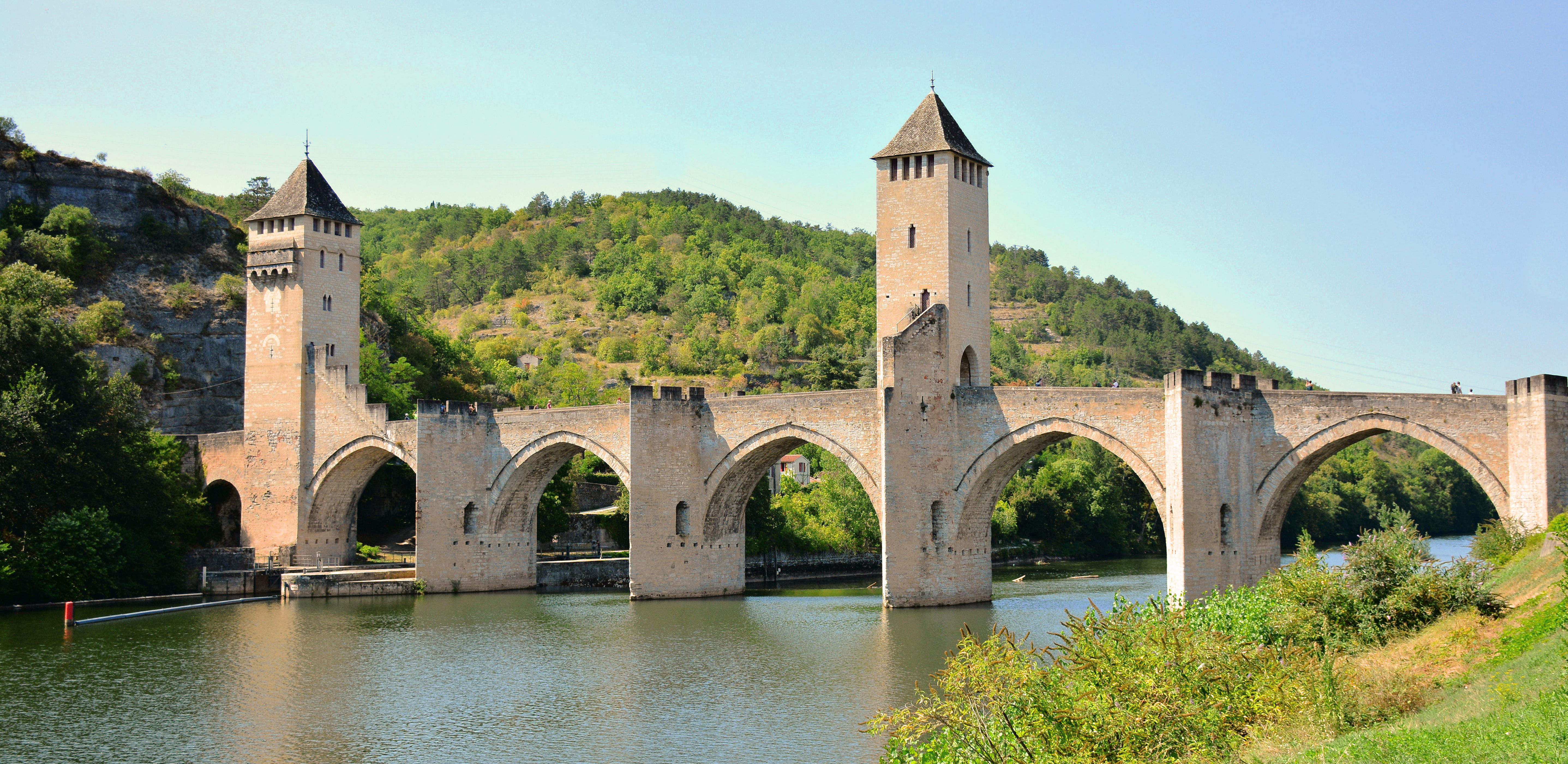
A photograph can make the Pont Valentré look like a fortified building that happens to stand in water. To understand it as part of Cahors, reverse the emphasis: this is a crossing that acquired gates, towers, repairs and new uses. The river is not its background. It is the obstacle, route and resource that explains why the structure exists.
The most revealing question is not simply “How old is it?” Ask what passed over it, what passed beneath it and what a gate could prevent from passing. Then add a fourth question: which parts of the scene belong to later restorations? Those distinctions turn a familiar monument into evidence of how a town managed movement.
A third crossing, not the beginning of crossing
The destination's historical account places the consuls' decision in 1306 and the first stone in 1308. It identifies the proposed western crossing at Valandre alongside two earlier routes: the Pont Vieux to the south and the Pont Neuf to the east. It also dates the bridge's conversion to pedestrian use to 1995. These are successive arrangements, not one unchanged medieval transport system. Cahors Vallée du Lot: Pont Valentré.
On a map, begin with the Lot's bend around Cahors rather than with a list of monuments. Mark the west, south and east directions identified in that account. The exercise is about the historical relationship between approaches; it does not assume that every old bridge survives in its original form or carries its original traffic.
A bridge creates a connection, but not every connection serves the same journey. Crossing the river and travelling through the town are different tasks. A route useful for one approach may be indirect for another. That is why the presence of an earlier bridge does not make a new crossing redundant.
Without toll accounts or other documentary evidence, it would be a leap to specify exactly how much each route earned, or which groups always used it. The safer conclusion is geographical: the western crossing expanded the possible ways into and out of Cahors. Its role should be understood in relation to other approaches, not as the town's only encounter with the river.
Read across and beneath. Follow the deck across the river, then compare it with the spaces through which water passes. This partial view does not show every tower or arch, and cannot settle the disputed completion chronology. Mike McBey, Pont Valentré, 20 August 2018, CC BY 2.0. Original image unchanged; a dated view, not a current access assessment.
Keep the construction chronology honest
The regional heritage inventory provides a useful corrective to a tidy building story. It considers the bridge and towers likely to have been built rapidly in the first quarter of the fourteenth century, while the tourist account gives a much longer sequence, with the towers probably finished around 1380. Both identify the early-fourteenth-century beginning; they do not agree on the completion timetable. Occitanie heritage inventory: Pont Valentré, IA46000088; Cahors Vallée du Lot: historical account.
For an ordinary explanation, “begun in 1308” is more defensible than pretending the differing accounts supply one undisputed completion year. If a school project or historical argument depends on the stages of construction, consult the specialist study and its evidence rather than choosing the date that produces the best story.
This is not a reason to stop looking at the bridge. It is a reason to separate a secure starting point from an interpretation of the building sequence. A structure can be usable before every defensive feature is complete; a later description can also compress several phases. Those are possibilities to investigate, not findings to insert into a gap without evidence.
A passage that could also interrupt passage
Read the towers in relation to the narrow route beneath them. A bridge is normally described as a solution to separation. Fortification adds a second function: the ability to regulate or obstruct movement along that solution.
From a safe public viewpoint, trace the line of travel across the deck. Notice how openings and changes in enclosure organise that line. Keep observation distinct from reconstruction. Seeing an opening today does not establish which people were checked there, how a particular guard shift worked, or whether a payment was collected on a particular date.
The contrast is still powerful. An unbroken road suggests free movement; a tower over a crossing reminds us that access can be conditional. That makes the bridge useful for thinking about civic power without inventing a dramatic battle or a permanent medieval checkpoint scene.
Do not climb defensive features or step outside permitted areas to improve a view. The structure is evidence, not equipment for reenacting its earlier uses. If a viewpoint is unavailable, an annotated plan can answer a spatial question more responsibly than an improvised physical inspection.
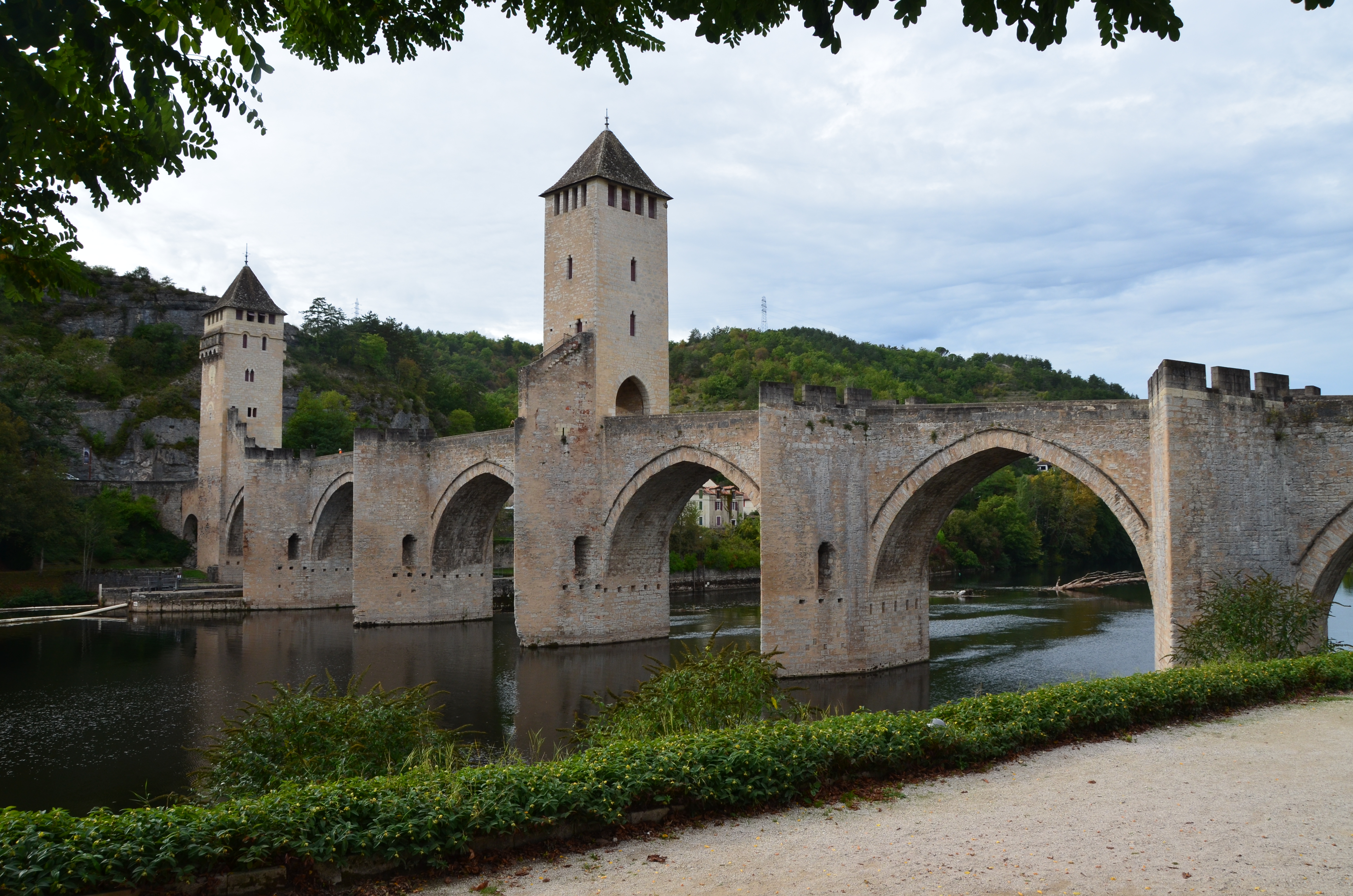
A change of level is a different route. In this closer view, identify the exterior stair rising beside the central tower. It makes movement within the structure visible, but does not establish who used it historically or permit access today. Rob vL, Pont Valentre, 1 October 2013, CC BY-SA 2.0. Original image unchanged; retained in full, without a new restoration-date claim.
The nineteenth century is part of what you see
The inventory records Paul Gout's intervention in 1879–1882 and explains that it accentuated the military character through reconstructed or modified features. The familiar fortified silhouette therefore needs to be read as a medieval structure shaped by later restoration, not as an untouched survival. The national protection record separately confirms classification as a historic monument in 1840. Occitanie heritage inventory; Ministry of Culture: protection notice PA00095027.
“Restored” should not be used as a synonym for “fake.” A restoration is itself a historical intervention. It shows what a later generation thought worth preserving, completing or making legible. Equally, protection does not prove that every visible detail dates from the same period.
A useful comparison has three columns: the feature visible now, the earliest securely dated representation you can locate, and any documented intervention affecting it. Leave a cell blank when the evidence is absent. That small discipline prevents a drawing, photograph and present-day view from being treated as interchangeable records.
For local documentary research, the inventory's references include the Fonds Gary at the municipal library of Cahors. This is a lead for locating material, not a claim that the collection has been inspected for this article or is immediately available without arrangements. Ask the library about the relevant item and consultation conditions before making a research journey. Inventory documentary references.
The bridge also belongs to the history of water supply
Near the bridge, the Maison de l'eau occupies the former Cabazat pumping station. The city's account describes machinery used to draw drinking water from the Fontaine des Chartreux, a distribution system beginning in 1854 and the plant's closure in 1971. Its permanent interpretation, “Le pont Valentré au fil du temps,” connects the bridge with other crossings and with nineteenth-century water pipes. This offers a local interpretive setting for understanding the bridge as infrastructure as well as architecture. City of Cahors: heritage exhibition sites and Maison de l'eau.
The distinction matters. A river crossing is not only a route for people or vehicles. A structure can also carry services that are much less visible in a scenic photograph. The question “What crossed here?” should therefore include water supply, not merely walkers, carts or cars.
At the interpretation centre, compare an explanation of pumping with an explanation of carrying water across a river. One concerns moving or raising water; the other concerns connecting parts of a distribution network. Do not assume that proximity alone explains every component's function. Look for labelled diagrams or ask which part of the system a surviving machine served.
The official 2026 listing gives the centre's address as 175 quai Albert-Cappus. For 25 October–1 November it lists afternoon opening every day; for 2 November–17 December the pattern changes to Fridays, Saturdays, Sundays and public holidays. Those are dated arrangements, not a promise of continuous year-round access. Recheck the listing before travelling. Official Maison de l'eau listing.
Conservation is not the same as a present-day access guarantee
The Fondation du patrimoine's project account describes deterioration requiring work, while reporting that investigations had not found major structural weakness. It discusses scaffolding and working arrangements intended to accommodate the bridge's uses. That is a conservation plan, not evidence that every approach and section is open on a particular day. Fondation du patrimoine: Pont Valentré restoration project.
As checked in October 2026, the destination presents restoration as a 2026–2031 project. Older announcements and general descriptions should not substitute for current site notices. This article has not verified an uninterrupted route across the bridge for every date, mobility requirement or stage of the works. Current destination project information.
For a visit, separate three decisions: can you reach a suitable riverbank viewpoint, can you enter the interpretation centre when intended, and is the bridge route itself available and suitable? A positive answer to one does not settle the other two. Do not treat a photograph of an empty deck as an access assessment.
A short crossing-reading exercise
Use this table in a notebook rather than trying to collect every historical detail at once.
| Question | Evidence worth seeking | Conclusion to avoid without it | |---|---|---| | Why this location? | The river bend and relationship to the other historical approaches | That this was Cahors' first or only bridge | | How was movement controlled? | Openings, a reliable plan and documented functions | A precise toll or guard routine inferred from a tower | | Which period is visible? | Dated representations and restoration records | That all stonework is unchanged medieval fabric | | What else crossed? | Water-supply interpretation and network diagrams | That a bridge served transport alone | | What is accessible now? | Current notices and confirmed visitor arrangements | That a long-term project description guarantees today's route |
For orientation, use the Pont Valentré, Cahors location search. This is an address-based search link, not a surveyed pin, rendered map or accessibility certification.
The most useful result is a modest one: a bridge understood as several systems sharing one structure. It connects banks, channels movement, preserves decisions about restoration and belongs to the town's water history. Keeping those systems distinct makes the view richer without requiring a legend to stand in for evidence.
Source register and limits
Remote research used regional inventory, municipal interpretation, national protection records, official destination listings and the restoration project account. No site visit, archive consultation or direct museum-object examination is claimed. Fonds Gary is an unexamined documentary lead. Official indexed text was used where direct inventory and municipal pages were unavailable. The completion-chronology disagreement remains unresolved; the national notice is used for its protection date, not its inconsistent main-century metadata. Photographs are unchanged dated views, not access surveys. Opening and works information is time-bounded and must be rechecked before a journey.