Free · France
Saint-Cirq-Lapopie: How river access shaped medieval trade
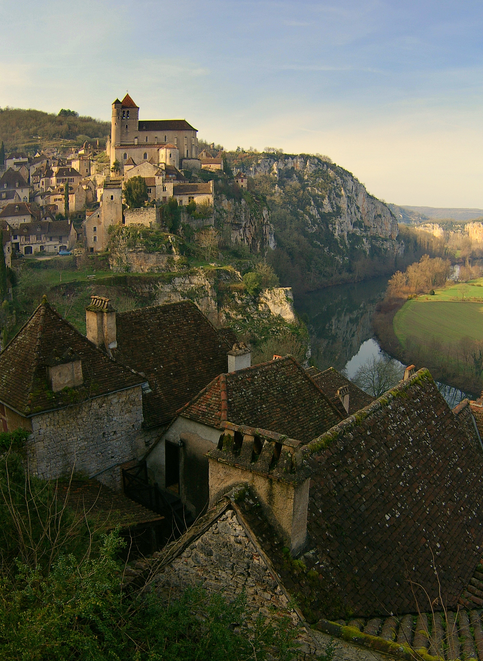
The Lot below Saint-Cirq-Lapopie looks like an obvious explanation for the village's commerce. Yet a river can be a route, a barrier and a source of power at the same time. To understand its economic role, “access to the river” must be broken into smaller questions: access to which bank, for what load, under whose permission and in which century?
That last question is essential here. The celebrated cliff-cut towpath near Bouziès is nineteenth-century infrastructure, not an intact medieval freight road. It is relevant to the longer history of navigation, but it cannot be used to illustrate every earlier transaction without qualification.
Three movements that a river view conceals
Separate movement along the Lot from movement across it and movement between the water and the village. These are distinct operations. A boat serving a crossing may be useful to someone reaching fields on the opposite bank without carrying goods to a distant market. A riverside mill may use water for power without being a port. A steep approach to a house may remain necessary after a boat has arrived.
The departmental heritage description emphasises Saint-Cirq-Lapopie's terraced, sloping form, with ramps and stairs between different levels. That physical arrangement cautions against imagining a continuous flat commercial waterfront outside the upper village's houses. Lot heritage route: Saint-Cirq-Lapopie urban-landscape section.
For a simple sketch, use three lines rather than one. Draw the river corridor, a possible crossing and a connection uphill. Label each line with a question mark until its historical use is documented. This is a way to organise evidence, not a reconstruction of a specific medieval route.
The missing connection. This dated view shows why reaching the river and moving along it are separate questions. It does not locate a medieval landing place, crossing or cargo route. Adam Baker, Simply Lapopie, 15 January 2007, CC BY 2.0. Original image unchanged.

A medieval mill establishes work at the water's edge
The Ministry of Culture's notice for the watermill at Portes-Roques records a documentary attestation in 1317, surviving fifteenth-century parts and an early-eighteenth-century restoration. Its longer account describes subsequent machinery changes and the end of activity in 1966. A medieval attestation therefore belongs to a structure with a long working history, not a building frozen in its first documented year. Ministry of Culture: watermill, PA00095237.
Lot Tourisme's account of the Aulanac mill identifies grain milling from the Middle Ages. It places the building at the foot of Saint-Cirq-Lapopie and distinguishes later restoration from earlier remains. Lot Tourisme: Aulanac mill and lock.
A mill gives a concrete reason for goods and people to reach the riverbank. Grain must reach the working site and processed material must leave it. That is a different economic relationship from a boat passing along the valley. The two can coexist without being identical.
Do not infer the medieval layout of every neighbouring installation from the mill's date. An attestation in 1317 does not date an adjacent lock, a present embankment or every visible wall. Each feature needs its own evidence.
The national notice identifies the property as private and describes its conversion to residential use. It is not a promise of routine interior access or a working-mill demonstration today. Observe only from permitted public space and confirm any specifically advertised opening. Ministry of Culture: ownership and use.
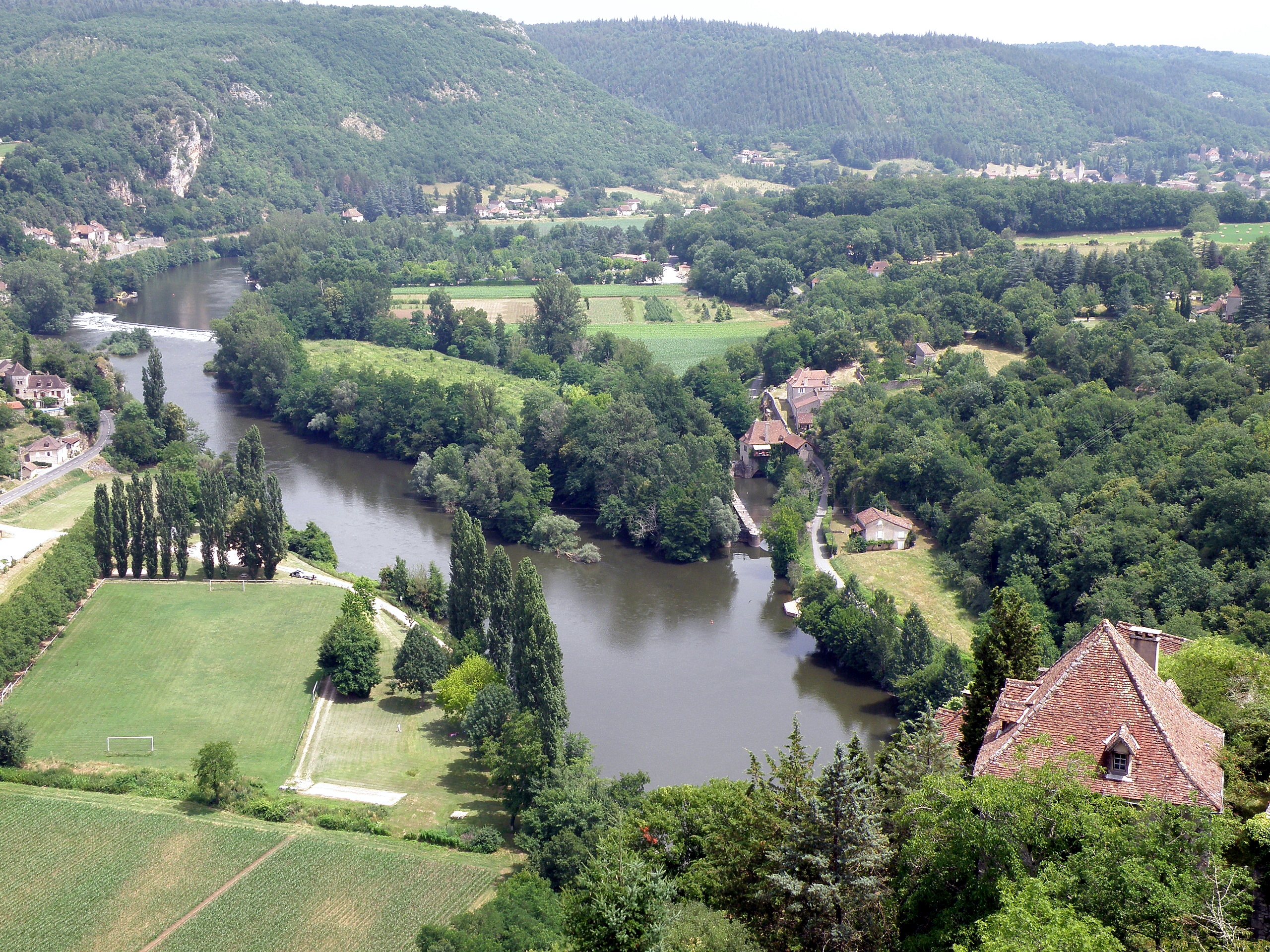
Separate the working site from the navigation channel. This 9 July 2010 view, taken from the village’s fort, is identified by its photographer as showing the Porte-Roques mill and lock on the right. It helps locate waterside installations in relation to the river; it does not date the lock, identify a medieval loading route or show the mill still operating. The 1317 documentary attestation belongs to the mill’s history, not automatically to every feature visible here. Photograph: Torsade de Pointes, original and provenance, CC0 1.0, unaltered.

A small contract makes crossing costs visible
Patrice Foissac's archive-based study describes a May 1512 vineyard agreement granting cultivators use of Guillaume de Saint-Géry's mill boat to cross the Lot. The author identifies the mill tentatively with the later Ganil site and explains that the arrangement avoided a detour through the port of Treguech and its toll. This is an early-sixteenth-century example, immediately beyond the medieval period, not a licence to invent the same arrangement centuries earlier. Société des Études du Lot: Saint-Cirq vineyard research.
The significance is unusually practical. A line across a river on a modern map says little about who could use a boat or what a crossing cost. Here, permission formed part of an agreement about working land. Access was a resource with consequences for time and expense.
It also prevents the word “port” from doing too much work. In this account, a named port belongs to the problem of crossing and the detour it imposed. The mere presence of the word does not establish a large export harbour or a particular quantity of cargo.
For any historical movement, ask four questions: who travelled, why, by what means and under what arrangement? If a source answers only two, leave the other two open. This is especially important when the surviving evidence is a lease or dispute rather than a comprehensive transport account.
Wine could move by land even beside the river
The same study identifies a 1499 trip to obtain wine at Saint-Cirq using mounts rather than an assumed river journey. Taken together, the dated examples show that local movement cannot be reduced to one mode. They do not supply a proportion of wine carried by road versus boat. Foissac: dated wine transactions and movement.
A sensible interpretation is limited: a river-adjacent economy could use crossings, paths and land transport as well as navigation along the water. Which option made sense depended on the particular task. That is an inference from the examples, not a reconstructed freight timetable.
The physical presence of a large river can make its role seem more dominant than the surviving records justify. Small movements—to a field, a cellar, a mill or a buyer—also matter. They are less spectacular in a landscape photograph but may be decisive for the people carrying them out.
The original notarial manuscripts have not been inspected for this article. The published research provides references for further investigation. Treat it as attributed scholarship, not as a claim that the underlying records were independently transcribed here.
Do not walk the nineteenth century and call it medieval
The destination dates the cliff-cut towpath by Ganil to 1845 and identifies the much later bas-relief by Daniel Monnier as a 1985 work. The path enabled towing along a difficult river edge. These dates make the site valuable in its own right, while ruling out a casual description of the carved passage or sculpture as medieval fabric. Official destination: Chemin de Halage.
The departmental heritage route gives 1847 for cutting this cliff section, rather than the destination listing’s 1845. These public accounts do not establish one undisputed year; both place the intervention in the nineteenth century. Lot heritage portal, towpath section.
The lesson is not that the path is irrelevant to older trade. It shows how much work could be required to turn a river margin into a usable transport corridor. What it cannot show, without separate evidence, is the exact route, equipment or labour arrangement used there five hundred years earlier.
A useful notebook has two columns: date of the economic activity being discussed and date of the visible infrastructure. Sometimes they match; often they do not. A mill with medieval documentation and later machinery, a nineteenth-century towpath and a twentieth-century artwork can share the same landscape without sharing a date.
Nor should a modern leisure boat be treated as a transparent reconstruction of a historic freight service. Its itinerary, propulsion, passengers and operating conditions may serve very different purposes.
The modern navigation landscape was rebuilt
In a March 2024 account, the Département du Lot describes the long interruption in navigation between 1927 and 1990 and the subsequent work of restoring and maintaining it. The same account explains the transfer of management of the public river domain to the Department. This is evidence of modern stewardship, not uninterrupted medieval infrastructure operating unchanged into the present. Département du Lot: navigation and river-domain management.
An earlier departmental report on the 2018 floods records substantial clearance work at Saint-Cirq's lock. It is a dated example of maintenance after damage, not a warning that the same obstruction exists now. Département du Lot: repairs after the 2018 floods.
Together, those accounts make a practical point: navigability is maintained. A river's existence and a boat's ability to use a particular reach are different facts. For a present-day walk or cruise, check current conditions and the operator's actual service; historical information cannot certify access or safety on a chosen date.
What a cultural house can—and cannot—add
The Maison Breton is also known as the Auberge des Mariniers, but its current cultural operator principally explains the house through Breton and the Surrealists' twentieth-century presence. That history is worth understanding on its own terms. A name associated with boatmen should not be converted into a verified reconstruction of medieval shipping practices. CISCM: Maison Breton and Maison Rignault.
This provides a useful contrast among local sources. The heritage notice dates a working building; archive-based research identifies particular agreements; the cultural house interprets a later artistic history; the Department explains modern river management. Each contributes something different. None is a universal authority for every period and function.
A practical river-history observation sheet
| Feature or record | What it supports | What it does not establish by itself | |---|---|---| | Mill attested in 1317 | A documented medieval working site | The date of every visible installation nearby | | 1512 boat-use agreement | A particular crossing permission and avoided detour | The normal route of all merchants | | 1499 land journey for wine | One recorded use of land transport | The overall share of trade carried by each mode | | Towpath dated 1845 or 1847 in the cited accounts | A nineteenth-century investment in the river corridor | An unchanged medieval tow route | | Current leisure navigation | A maintained contemporary service | Continuous operation since the Middle Ages |
For orientation, the Bouziès towpath location search points to the named area, not a surveyed trail entrance or a verified accessible route. Check local notices, conditions and the planned return before setting out. Do not enter a private mill or operational river structure to complete an observation.
River access shaped the possibilities around Saint-Cirq-Lapopie, but it was not a single, automatic advantage. It involved routes to the water, permissions to cross, places to work and later investments in navigation. Keeping those relationships—and their dates—separate produces a more convincing history than making the entire riverbank medieval.
Source register and limits
Official heritage, tourism, river-management and cultural-house sources were consulted remotely; Foissac’s archive-based research was read as indexed text, not original manuscripts. No toll amount or mode share was established. The 1317 attestation belongs to the mill, not automatically to the lock. The 1845/1847 towpath-date disagreement remains explicit, while both dates are nineteenth-century; the 1985 relief is later still. Navigation interruption is 1927–1990, and 2018 clearance is historical, not a current obstruction warning. Two dated original photographs are unchanged; neither identifies a medieval cargo route or certifies access.