Free · France
Najac: How a bastide differs from a castle town
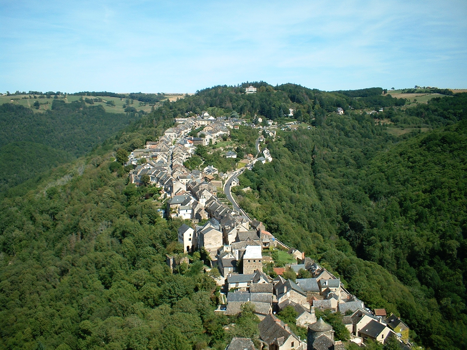
Najac is a useful place to lose an overly tidy definition. A visitor may encounter “castle town,” “royal bastide” and the wider destination name “Bastides du Rouergue” during the same afternoon. The tempting response is to choose one label and declare the others wrong. A more revealing response is to ask which part of the settlement's development each description is trying to explain.
The distinction matters because a town's origin, its later expansion and its present heritage branding are different things. A castle can influence the formation of a settlement; later authorities can regulate or extend it; a modern cultural territory can include places with several kinds of medieval origin. None of these automatically cancels the others.
Begin with the relationship, not the silhouette
A bourg castral is a settlement understood through its relationship with a castle. In Najac's case, the regional heritage service describes a town developing along a narrow rocky ridge beneath a powerful stronghold. It connects major thirteenth-century fortress works with Alphonse de Poitiers's assertion of authority. This is an explanation of settlement and power, not just a picturesque description of a tower on a hill. Pays d'art et d'histoire: Najac.
A bastide, in the medieval southwestern French context considered here, is associated with an organized settlement project. Founding arrangements, the allocation of plots, commercial space and the rights governing inhabitants can be as important as the appearance of the streets. The evidence should be examined place by place rather than reduced to “a square with arcades.”
A nearby comparison helps. The same heritage service describes Villefranche-de-Rouergue as a new town founded in 1252 by Alphonse de Poitiers, laid out for exchange on a relatively gentle slope beside the Aveyron. Its origin as a planned foundation gives the comparison historical substance; it is not merely a matter of which place looks more regular on a tourist map. Pays d'art et d'histoire: Villefranche-de-Rouergue.
Do not turn that comparison into a universal rule. “Castle town” does not mean every street grew without organization, and “bastide” does not mean all surviving façades were built together. A plan can endure while its buildings change. Conversely, a later intervention can regularize part of an older settlement.
Najac's labels point to different phases
The regional inventory classifies Najac as a bourg castral. Its historical account places an early fortified settlement before the middle of the twelfth century, followed by substantial growth and suburbs. It records a charter of customs granted in 1255 and municipal references to several suburbs by 1268. The charter is evidence for the community's rights and organization; its date should not simply be relabelled the birth date of every part of Najac. Occitanie inventory: IA12000217.
The local tourism office uses a broader sequence: a castle settlement followed by eastward expansion, which it describes in bastide terms. Its Najac office page identifies Le Bourguet and Le Barriou along the ridge street, leading towards the market space. The useful reading is phased development, not a claim that an empty site was covered by one complete grid in a single operation. Tourism office: Najac settlement description.
These accounts differ in emphasis. The inventory's category foregrounds the older nucleus; the visitor description foregrounds later growth. A responsible explanation should preserve that difference instead of presenting a disputed-looking word as if it settled every historical question.
Try writing a three-part description: earlier nucleus / documented extension / surviving form. Add a source to each part. If the source tells you only about a later market space, do not let it silently supply a precise founding date for the older houses.
A visible form is not a founding document. Trace the long built line in this dated view, then return to the article’s distinction between an earlier nucleus and later expansion. The photograph shows spatial relationships; it cannot supply a charter date or date every facade. Roger Davies, Rooftops Najac, France, 16 September 2002, CC BY 2.0. Original photograph unchanged; not a current route or market record.
What the place du Faubourg actually demonstrates
The tourism office describes the place du Faubourg as a long, narrow space developed for markets, bordered by rows of houses forming a linear layout. It identifies covered fronts on the southern side, associated with fifteenth- and sixteenth-century buildings. Its current visitor information places the regular market there on Sunday mornings. Najac market and square.
That gives the reader something specific to examine: a commercial space adapted to a constrained ridge, rather than an ideal square copied from a textbook. Look at how the open area meets the street, how the covered edge relates to the frontage and how the line continues towards the older settlement.
The observation still needs limits. Present market use does not prove that every stall position is medieval. A covered frontage does not date the whole plot. A regular row does not identify its founder without additional evidence. These cautions are not obstacles to enjoying the square; they prevent a familiar urban feature from becoming a shortcut to an unsupported history.
For a less crowded look at the frontage, a non-market day may be useful. For observing the square's present commercial function, market time answers a different question. Confirm any special-day changes locally; the ordinary weekly listing is not a guarantee that every trader will attend.
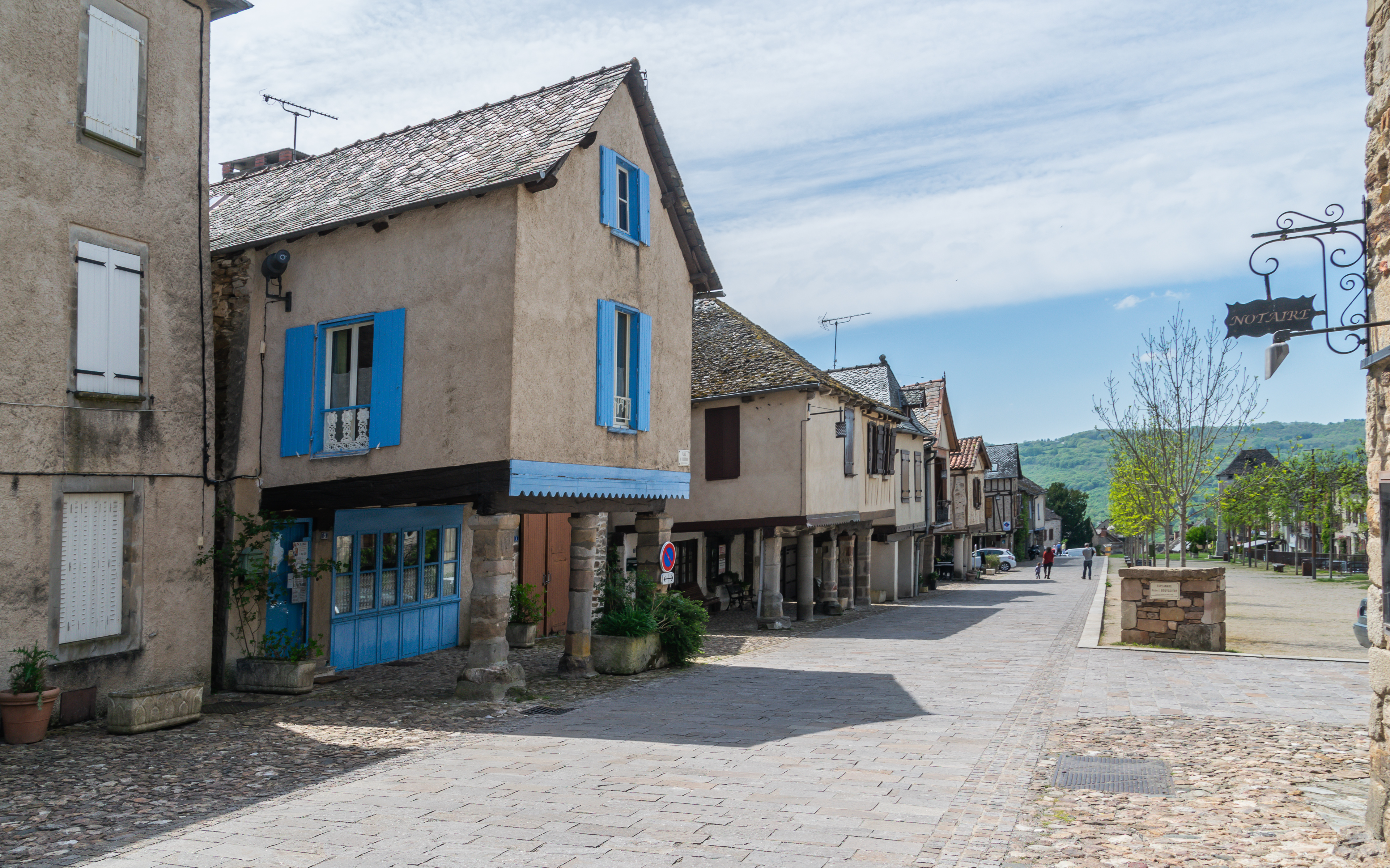
Compare the covered edge with the open space. This 1 May 2019 photograph of place du Faubourg shows a line of building fronts and columns beside an elongated public area. It makes the relationship discussed above visible without turning it into proof of a single foundation date. It is not a market-day record, a dated survey of every facade or an identification of number 70. Photograph: Krzysztof Golik, original and provenance, CC BY-SA 4.0, unaltered.

A building study is a useful brake on broad labels
The regional inventory's record for 70 place du Faubourg assigns possible phases to the fourteenth century and first half of the sixteenth century, explicitly retaining uncertainty. It interprets the ground floor as probably having housed a shop. This level of qualification is valuable: a plausible commercial function and proposed dates are not the same as a surviving lease identifying a named merchant. Ministry of Culture: house at 70 place du Faubourg, IA12000262.
Use the example to separate three scales:
| Scale | Question | Suitable evidence | |---|---|---| | Settlement | How did Najac originate and expand? | Historical synthesis, documents and urban analysis | | Block or plot | How was space divided and connected? | Plans, cadastral comparisons and physical relationships | | Building | Which parts were constructed or altered, and for what use? | Fabric study, dated records and qualified interpretation |
A good answer at one scale does not automatically answer the others. Calling the wider settlement a bastide does not date a window. Dating a house does not determine when the entire street was first laid out. This is why a short inventory entry can be more useful than a sweeping claim about a perfectly preserved medieval town.
Charters are evidence, not magic labels
Elsewhere in the regional inventory, the account of Sauveterre-de-Rouergue explicitly links its foundation to a paréage, an arrangement negotiated among founding authorities. That gives one concrete example of the institutional evidence behind a bastide's creation. It does not establish that every place bearing the name must possess an identical surviving document. Occitanie inventory: Sauveterre-de-Rouergue, IA12000079.
For Najac, ask what a document does rather than simply whether it is called a charter. Does it establish a new settlement, confirm existing privileges, regulate dues or describe an extension? Those are different acts. A confirmation may refer to a community already present. An agreement among authorities may precede physical construction. A later copy may preserve information from an earlier text without being the original parchment.
The original Najac charter was not examined for this article. The account above relies on the regional inventory's historical synthesis. Anyone making a more precise claim about individual clauses should first locate the edition or archival reference, identify what survives and check the wording. A tourist label is not a substitute for that step.
The local interpretation centre is the place to test the comparison
The Maison du Gouverneur's permanent exhibition brings landscape, history, urbanism and architecture into one route. Its own description identifies a medieval merchant house now housing a CIAP—an architecture and heritage interpretation centre—with models and other media. This is an appropriate place to ask how Najac relates to the different settlement forms in the surrounding territory. Maison du Gouverneur: permanent interpretation.
Do not confuse the permanent route with every temporary exhibition advertised in an old programme. The heritage service's 2025 brochure featured an exhibition comparing sauveté, bourg castral and bastide. That is a dated programme, not proof that the same temporary exhibition remains installed in October 2026. The centre's current programme and opening information should govern a visit. Historical 2025 programme, current centre website.
A useful question for the displays is: Which image shows a documented historical plan, and which is a modern explanatory reconstruction? Both can teach something, but they have different evidential status. Record the date attached to a plan before using it to describe the medieval settlement.
A conclusion more useful than a yes-or-no answer
Najac shows why urban history is better read as a sequence than a badge. Its castle-related origin, later extensions, commercial frontage and municipal organization can all be discussed without forcing every phase into one geometrical ideal. The broad bastide destination also includes places whose histories are not identical.
For your own notes, finish with two sentences. First, explain the castle-town relationship using a source. Second, identify the later planned or organized feature you can actually support. If those sentences are accurate, you have learned more than a label alone could tell you.
Location reference
Search map: place du Faubourg, Najac, France. Orientation link only, not a verified accessible itinerary or exact entrance pin. The ridge route contains slopes; consult current local guidance before combining stops.
Source register and limits
Official heritage, regional inventory, tourism and interpretation-centre sources were consulted remotely. No original charter, archival plan, building inspection or museum visit is claimed. Regional and some official heritage text was accessed through indexed versions; direct verification screens or server failures were not bypassed. The 2025 temporary-exhibition programme is historical evidence, not a current installation promise. Uncertain building phases and probable shop use remain qualified. Both photographs are dated, unchanged context and cannot establish a founding date or identify number 70.