Free · France
Provins: Medieval fairgrounds and fortified trading streets
A fair was a relationship between spaces
Provins is not important merely because a medieval-looking town happens to host a medieval festival. UNESCO's account identifies a surviving urban arrangement shaped by fairs and the wool industry: merchant houses, storage spaces, open areas, religious buildings and defences worked within a commercial system. The World Heritage property was inscribed in 2001 for that ensemble, not for an isolated castle. UNESCO, Provins
The distinction changes the question to ask of a street. Instead of treating the buildings as scenery, consider how people and goods passed between enclosure, thoroughfare, square and store. This article follows that relationship in the upper town, especially between Porte Saint-Jean, rue Saint-Jean and Place du Châtel. It does not attempt to map every fair stall or reconstruct a particular trader's journey.
A commercial town needed places where strangers could gather and transact, but also places where goods could be held apart from the crowd. Its openness was organised rather than unlimited. The surviving architecture makes that tension visible without preserving a complete record of daily movement.
The gate did not mean a sealed town
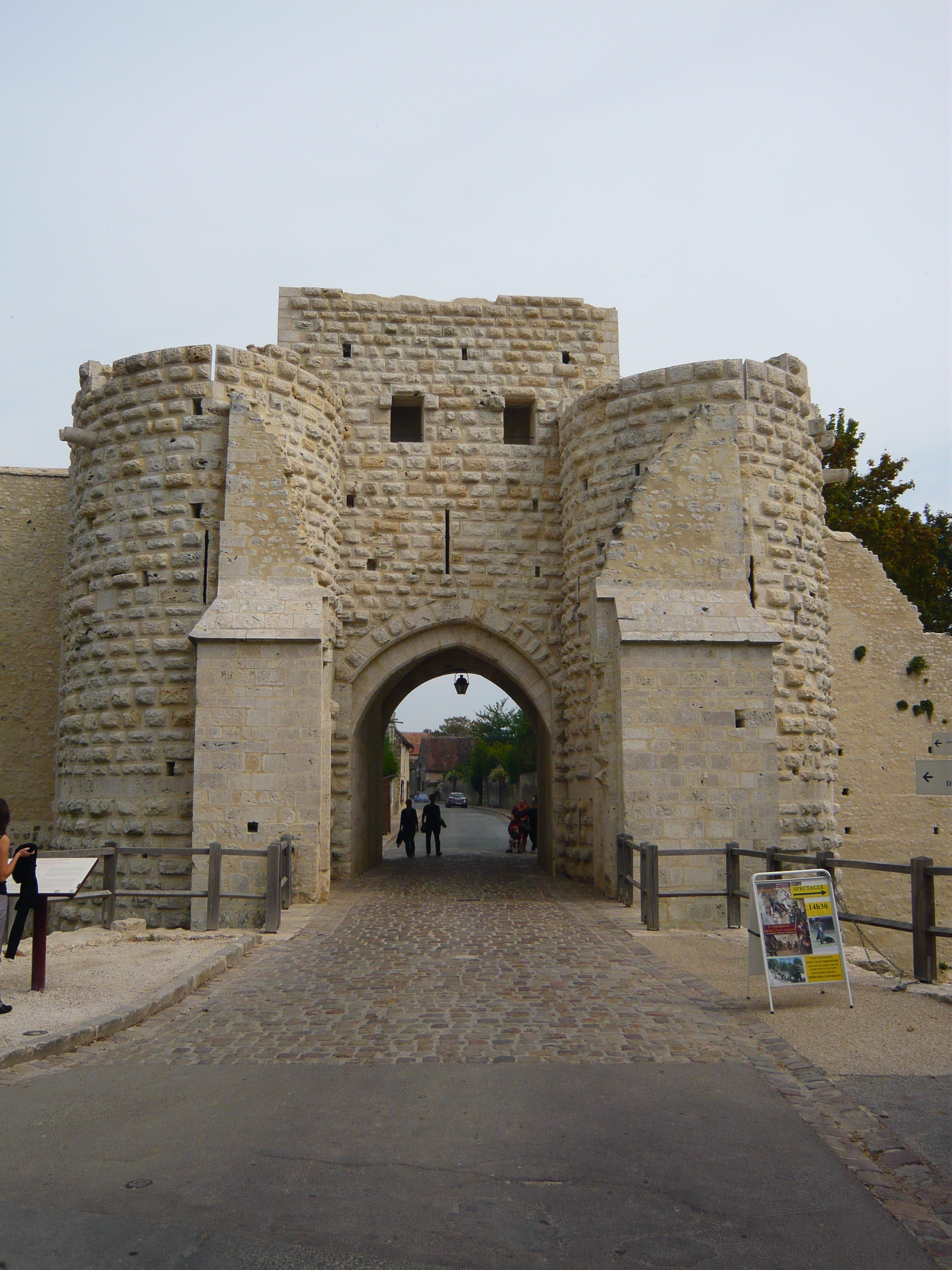
The official account of the ramparts distinguishes the formerly enclosed town from the surviving defensive circuit. About 1.2 kilometres remain around the upper town, with Porte Saint-Jean and Porte de Jouy as its two surviving gates. The disappearance of other stretches matters: the present wall line should not be mistaken for an intact enclosure of all medieval Provins. Provins Tourisme, ramparts
A gate is an opening deliberately made in a barrier. Read in relation to commerce, its importance lies in that double function, not simply in the height or thickness of nearby masonry. Protection and passage were compatible requirements. The visible remains establish the defensive setting; they do not, by themselves, reveal the identity of everyone admitted or the procedure applied to every consignment.
This is also why an empty modern approach cannot stand in for a medieval crowd. The monument preserves a structure through which movement was channelled. The density, timing and experience of that movement require other kinds of evidence.
Porte Saint-Jean in September 2009. The surviving opening frames a street beyond the fortified entrance. Modern pedestrians and signs are not evidence of medieval gate procedures or present-day access arrangements. Photo: Laifen, Wikimedia Commons; CC BY-SA 3.0. Unmodified by publisher.

A route links defence to exchange
The tourist office's 2023 guide identifies Porte Saint-Jean as a thirteenth-century defence of the old Paris road. Its paired almond-shaped towers frame an approach that continues through the gate along rue Saint-Jean. The guide places the merchant building now called the Grange aux Dîmes on this street, before the route reaches Place du Châtel. Provins Tourisme, 2023 visitor guide, p. 1
This is useful spatial evidence, even though the publication was written to guide modern visitors. It connects an external approach, a controlled opening, a trading street and a market space. None of these elements makes full sense as a self-contained attraction.
The guide does not prove that all merchants entered by this gate, or that every load continued to the square. Nor should its suggested walking circuit be confused with an excavated medieval itinerary. Its value here is more limited and more precise: it makes the physical relationship legible. A street serving commercial premises was also a connection between different scales of activity, from long-distance arrival to local storage and exchange.
The doorway beneath the street frontage
The ICOMOS assessment reproduced in the city's planning annex describes vaulted storage spaces opening towards streets through substantial doors and stone stairs. It differentiates the upper town's underground cellars from storage partly above ground in the lower town, where ground conditions affected construction. The same commercial requirement could therefore produce different relationships between floor level and street. Municipal planning annex, ICOMOS assessment, PDF p. 153
That threshold is a small but revealing feature. It links the public circulation space to a room where merchandise could be kept. Looking only at upper façades would miss part of the infrastructure that supported the fairs.
The assessment also separates mixed residential-commercial buildings from more exclusively commercial ones. It is therefore unsafe to imagine every old house operating in exactly the same way. A vault suggests a capacity and a building type; identifying its particular contents, tenant or transaction still requires documentary evidence. Architectural similarity is not a substitute for a dated inventory, and a storage entrance is not proof that every room behind it had a single unchanging use.
The square was not just an empty centre
A 2025 departmental account places trading on Place du Châtel and associates its Croix des Changes, also called the Croix aux Édits, with monetary exchange. It connects the square to commercial activity near the remains of Saint-Thibault church and discusses the denier provinois. Crucially, it also acknowledges that the square's present configuration differs from its earlier one. Seine-et-Marne, history of the Champagne fairs
The point is not to assign every surviving patch of paving a medieval function. It is that exchange required shared space as well as enclosed premises. Money-changing belonged to the practical organisation of trade, not simply to its picturesque atmosphere.
This departmental article appeared in the context of a modern medieval event. It is a public interpretation of history, not a contemporary description by a fair participant. Its place-names help connect economic functions to the town; they do not establish the precise location of every operation through successive centuries. A festival may reactivate the idea of a trading square without reproducing the historic fair's rules, participants or commercial scale.
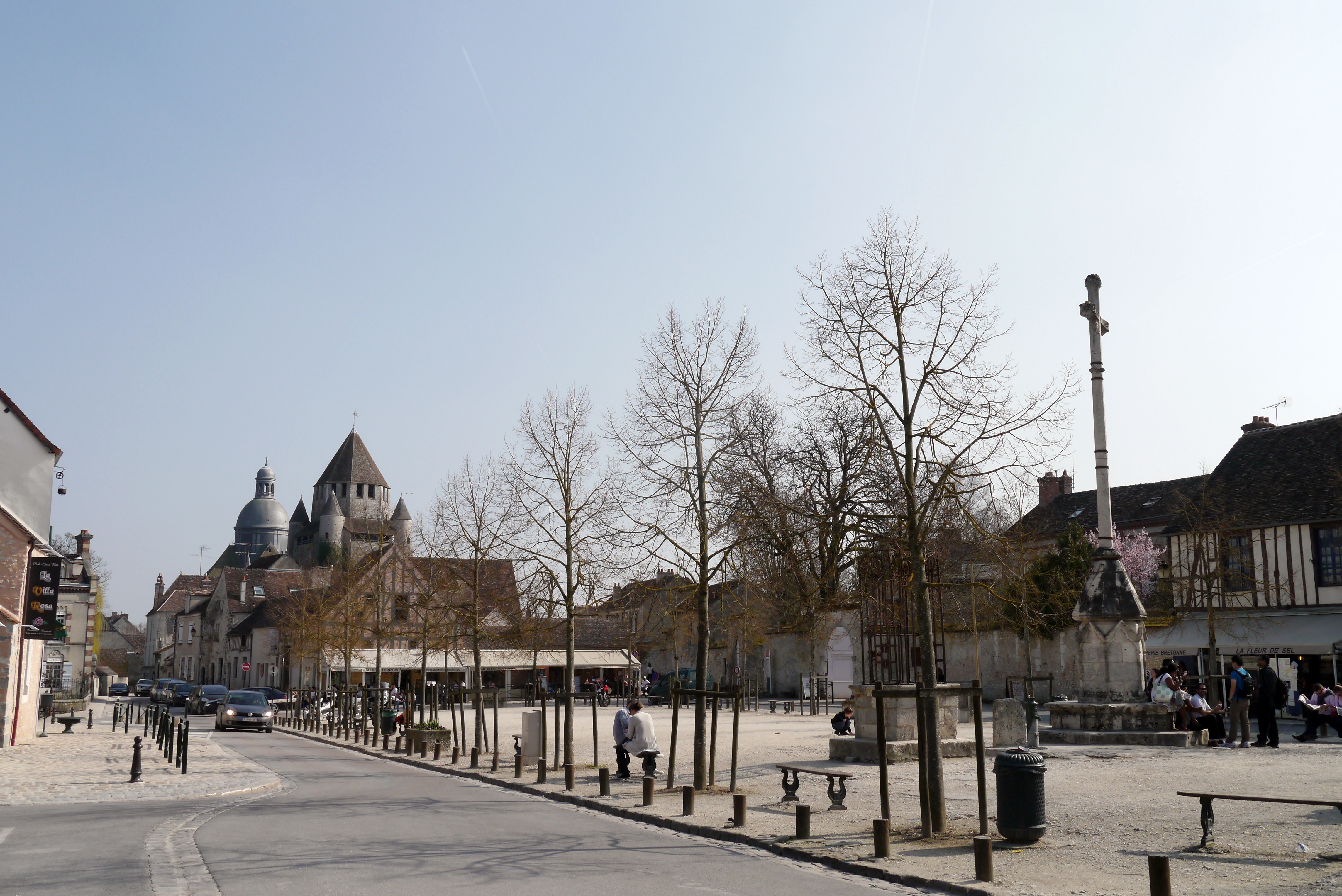
Place du Châtel seen from its northwest corner in March 2012, with the Croix des Changes at right. The photograph shows a later civic setting, not the medieval arrangement of fair stalls or proof of a particular money-changing transaction. Photo: Poulpy, Wikimedia Commons; CC BY-SA 3.0. Unmodified by publisher.

Paper survives differently from stone
The local heritage-library catalogue identifies manuscript 47 as a parchment roll containing a copy, collated in 1521, of Philip VI's 1349 ordinance for the Champagne and Brie fairs. It further notes that this copy depended on an authenticated transcription of 1422. This is evidence transmitted through successive acts of copying, not an original 1349 document inspected for this article. Réseau des médiathèques du Provinois, digitised manuscript catalogue
The catalogue also describes manuscript 92, Michel Caillot's seventeenth-century compilation, with later annotations, as containing numerous fair-related documents alongside privileges and other local records. These entries show that the memory of commerce was preserved through legal and antiquarian practices as well as through buildings.
They also impose a limit. A catalogue description confirms the existence and character of a source; it does not license paraphrasing clauses that have not been read. The fair can be recognised as a regulated institution without inventing a toll, penalty or gate inspection. The difference between a medieval act and a later witness to it is part of the history, not a technical inconvenience.
Two ways to make trade tangible
Inside the Grange aux Dîmes, official interpretation uses staged figures and scenes to explain trades and merchant activity. Its cast includes a cloth merchant, a money-changer and merchants associated with Italy and Flanders. Such a display makes specialised roles comprehensible, but its people and conversations are interpretive constructions, not a preserved fair gathering. Provins Tourisme, Grange aux Dîmes
The Musée de Provins et du Provinois offers a different evidential relationship. The Ministry of Culture's collection record lists medieval keys, pavement tiles and water outlets from a twelfth-century fountain. It describes holdings assembled through gifts, purchases, institutional deposits and recoveries during works or excavations. These objects bring material life into view, but the record does not identify a listed key as belonging to a particular merchant's store. Ministry of Culture, museum record M0383
A reconstructed scene explains a possible activity; a collection object has its own provenance to investigate. Neither automatically fills the gaps left by the other. Together they encourage more exact questions about access, surfaces and amenities without turning plausible associations into documented ownership.
The distinction is especially useful for a fortified commercial street. A key raises questions about who could enter and who could exclude, but its shape alone cannot answer them. A tile makes a finished surface tangible without identifying the social standing of everyone who crossed it. Conversely, a figure labelled as a merchant can explain an occupation while telling us nothing about the biography of a real tenant. These are not reasons to dismiss either display. They are reasons to separate the physical evidence an object carries from the broader account that an exhibition builds around it. That separation keeps the everyday life of trade from becoming an invented anecdote.
Keeping the setting is a present-day decision
Provins's October 2025 explanation of its planning revision states an intention to protect municipally owned plots beside the ramparts and continue acquiring land there. It places this alongside green spaces, ecological connections and softer forms of movement. The article anticipated approval of the final planning document at a forthcoming council meeting; it is not, by itself, proof that every proposed purchase or intervention occurred. Ville de Provins, planning-revision explanation
This policy language reveals a further layer of the fortified trading landscape. What remains legible depends partly on decisions about surrounding land, not only on repairs to towers. Maintaining an approach or an open setting requires choices in a functioning town.
The gate, street, square and storage doorway thus tell a connected but incomplete story. Stone records arrangements; manuscripts preserve mediated evidence of regulation; museum interpretation supplies explanations; planning expresses present intentions. Reading them together makes Provins more than a convincing backdrop. It makes the town a place where the organisation of exchange can still be questioned in precise, local terms.
Location orientation
Provins, France — general map search. This town-level orientation is not a verified entrance, route or access claim. It is not a reconstructed medieval itinerary.
Source register
All sources opened on 27 October 2026. Links appear at the relevant claims above.
- UNESCO: significance of the urban ensemble.
- Provins Tourisme, ramparts: surviving circuit and gates.
- Provins Tourisme, 2023 guide: Saint-Jean approach and street sequence; obsolete practical information excluded.
- Municipal UNESCO annex: reproduced ICOMOS architectural assessment; historical assessment, not a declaration of current planning status.
- Seine-et-Marne, 2025 article: square and exchange; modern interpretive context retained.
- Provinois manuscript catalogue: descriptions of manuscripts 47 and 92, not a transcription analysis.
- Provins Tourisme, Grange aux Dîmes: staged interpretation.
- Ministry of Culture M0383: museum collection categories and formation.
- Municipal planning article, October 2025: stated intentions, not completed acquisitions.
Evidence limits
No original fair ordinance or merchant itinerary was examined. No particular surviving cellar is assigned undocumented goods or occupants. The complete historic enclosure is not equated with its surviving upper-town section. No festival is presented as an exact reconstruction. The museum's general collection record does not establish individual findspots or present display status. A local museum visitor page timed out; the successfully opened Ministry record supports the museum comparison instead. Current access arrangements and the subsequent implementation of planning proposals are outside this manuscript's verified scope.